Eric Webb
@webberweather
Gov't meteorologist part of the weather industrial complex. UNCC & NCSU Alum Opinions are my own & not a reflection of my employer
ID: 969293274
http://www.webberweather.com/ 25-11-2012 03:36:57
40,40K Tweet
76,76K Followers
1,1K Following
 on Twitter photo Real")
 's Twitter Profile Photo")
 on Twitter photo Some new Hovmoller plots out. You can now see subsurface plots which add some context to the ENSO states. I've also added Hovmollers for the EPS model and velocity potential! Something you don't see a whole lot of around")
 on Twitter photo Nothing says the Tropical Atlantic has Hadley Cell problems quite like seeing the warmest mean SSTs up at 30N (even outside the Gulf!)
🤢")
 on Twitter photo Another way to conceptualize the impact of equatorial upper-level westerly winds on the Atlantic is consider the curl of the wind vector
A positive curl here favors Tropical Upper Troposphere Troughs (TUTTs), which leads to more wind shear & dry/stable air in the Atlantic")
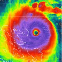
 on Twitter photo Tropical Storm #Iona in the Central Pacific looks primed to rapidly intensify.
A closed and thick cyan ring on a recent microwave pass coupled with increasing organization and an eye-like feature trying to develop on IR
👀")
 's Twitter Profile Photo")
 on Twitter photo Central Atlantic waves are pretty convection-free at the moment, as background stability and dry air suppresses rising motion. Not surprisingly, there isn't much model signal for development anymore - the AI models seemed to have been overzealous. For now it seems like")
 on Twitter photo Next week’s heatwave in New Mexico is likely being forced by an ongoing MJO passage thru the NE Pacific.
The latent heat from the MJO & the several TCs it should spawn will help reinforce the ~600 dam ridge over New Mexico via deep-layer subsidence & a Gill-type response
#nmwx")