The Wx Geek ☈ 🇨🇦
@thewxgeek1
Trained Wx spotter with the NWS. SkyWarn, COMET.
ID: 1522505970424991744
06-05-2022 09:18:23
2,2K Tweet
93 Takipçi
389 Takip Edilen
 's Twitter Profile Photo")
 on Twitter photo Great Lakes ice update for March 31, 2026: Combined 15% | Lake Superior 21% | Lake Michigan 7% | Lake Huron 25% | Lake Erie 2% | Lake Ontario 1% | #GreatLakes")
 's Twitter Profile Photo")
 's Twitter Profile Photo")
 on Twitter photo Even in darkness, we glow.
In this image of Earth taken by the Artemis II crew, we can see the electric lights of human activity. In the lower right, sunlight illuminates the limb of the planet.")
 's Twitter Profile Photo")
 on Twitter photo The Sun today with the Seestar S30 Pro")
 's Twitter Profile Photo")
 on Twitter photo 🌡️25.8°C Hamilton, ON = highest temperature of the year in Canada. Yesterday's max was 3.6°C!
Over 23-24°C in Belleville, Brantford, Burlington, Cedar Springs, Chatham-Kent, Delhi, London, Oshawa, Peterborough, Ridgetown, St. Catharines, Toronto, Vineland and Windsor. #ONstorm")
 's Twitter Profile Photo")
 on Twitter photo Stripping away \"the cloud\" to visualize a supercell's anatomy, there are several take aways...
1. Downdrafts are not steady state features!
2. SVCs can contribute to *LLMC* enhancement
3. RFD surges may \"collect\" & converge vortex patches beneath the LLMC")
 's Twitter Profile Photo")
 's Twitter Profile Photo")
 on Twitter photo If the probability for severe nosing into southwestern ON is higher than Oklahoma - that's a win for April.")
 on Twitter photo 🌡️26.3°C Windsor, ON ➡️ New highest temperature of 2026 in Canada.
The heat was concentrated in the extreme south of Ontario.
🌡️23.7°C Harrow
🌡️22.7°C Sarnia
🌡️21.5°C Ridgetown
🌡️20.9°C Point Pelee
No other station was over 20°C in the province and very few over 10°C. #ONstorm")
 's Twitter Profile Photo")
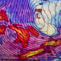
 on Twitter photo ENSO analogs are based on the thin equatorial strip being warm (and flanked by cool) or cool (flanked warm).
Therein you get the classic convective lifting-subsidence (or vice versa) process that swings patterns across North America & adjacent ocean basins.
THESE ARE DEFUNCT.")
 on Twitter photo Incredible marine flow across our urban/coastal corridor today as well as Nova Scotia.
Yesterdays' upper low spawned a modest surface low creating backing flow.
It will be shoved back east yet replaced by a cold snap.
Following warming shallow & the Appalachians may halt advance.")
 's Twitter Profile Photo")
 on Twitter photo Contrary to the Pacific, the Atlantic's SST configuration appears exceptionally hostile for TC development this season.
Note the cold canary current showing up on both the standard SSTa and global mean removed SSTa plots. El Nino aside, this alone would suggest below average")
 's Twitter Profile Photo")
 on Twitter photo")
 's Twitter Profile Photo")
 on Twitter photo More bad news for the climate cult.
A new paper has been published in the Journal of Theoretical and Applied Climatology by Dr. John Christy of UAH detailing the decline in the frequency of hot and cold extremes in the United States.
🗨️ “The results indicate that extremes in")
 's Twitter Profile Photo")
 's Twitter Profile Photo")
This is the current view of the Severe Storm near Wellington, Kansas. Watch live via: youtube.com/@DanielShawAU/… NWS Wichita NWS Norman #okwx #kswx
 on Twitter photo This is the current view of the Severe Storm near Wellington, Kansas. Watch live via: youtube.com/@DanielShawAU/… <a href=\"/NWSWichita/\">NWS Wichita</a> <a href=\"/NWSNorman/\">NWS Norman</a> #okwx #kswx")