Joint Polar Satellite System (JPSS)(@JPSSProgram) 's Twitter Profileg
Joint Polar Satellite System (JPSS)

@JPSSProgram

Official account of the Joint Polar Satellite System (JPSS). A collaborative @NOAA and @NASA program for latest generation of polar-orbiting weather satellites.

ID:168537920

linkhttps://www.jpss.noaa.gov calendar_today19-07-2010 17:00:15

4,9K Tweets

21,8K Followers

98 Following

Joint Polar Satellite System (JPSS)(@JPSSProgram) 's Twitter Profile Photo

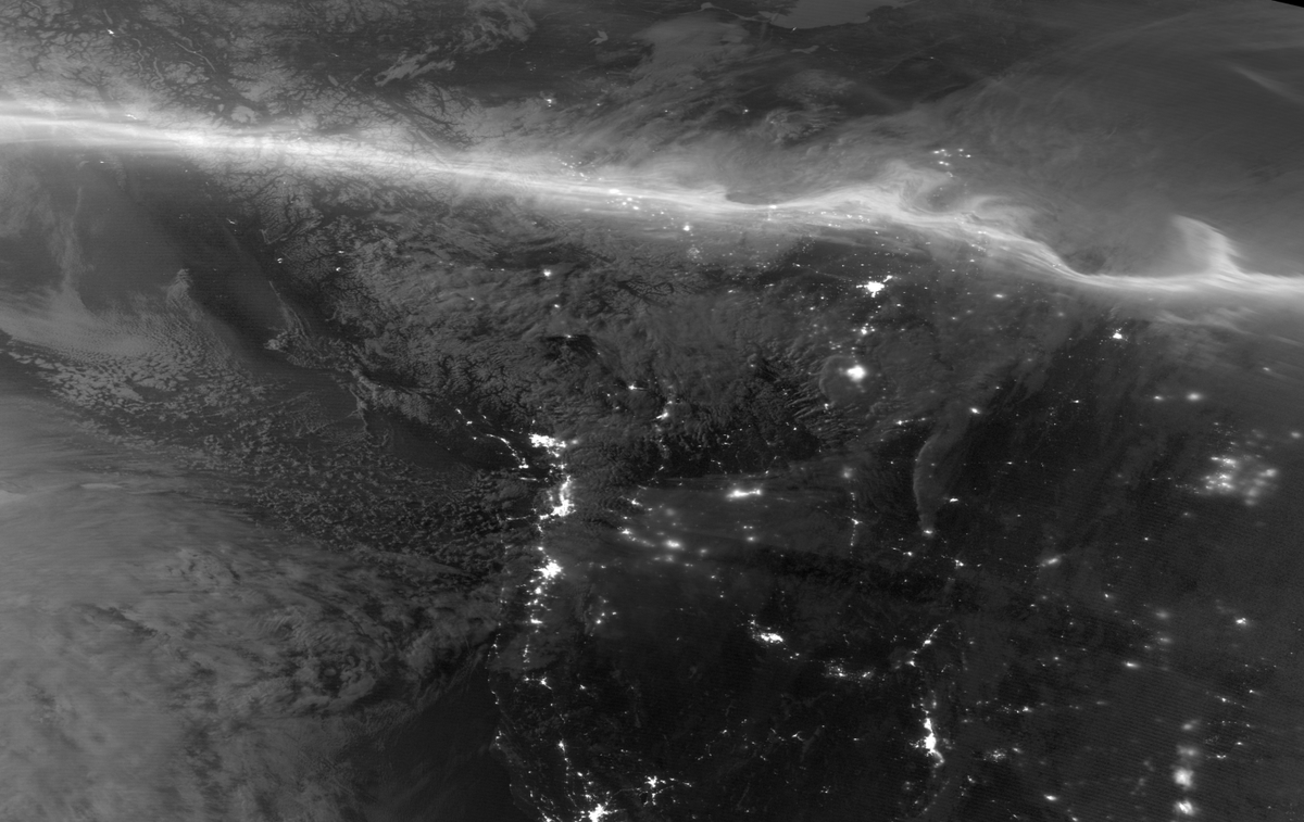
Another type of phenomenon that NOAA's JPSS satellites observe is the aurora borealis, which results from space weather caused by the Sun’s solar activity! ✨

A monochrome satellite image from April 16, 2024, captured the glow of the aurora borealis over Canada.

Another type of phenomenon that @NOAA's JPSS satellites observe is the aurora borealis, which results from space weather caused by the Sun’s solar activity! ✨ A monochrome #NOAA20 satellite image from April 16, 2024, captured the glow of the aurora borealis over Canada.
account_circle
Joint Polar Satellite System (JPSS)(@JPSSProgram) 's Twitter Profile Photo

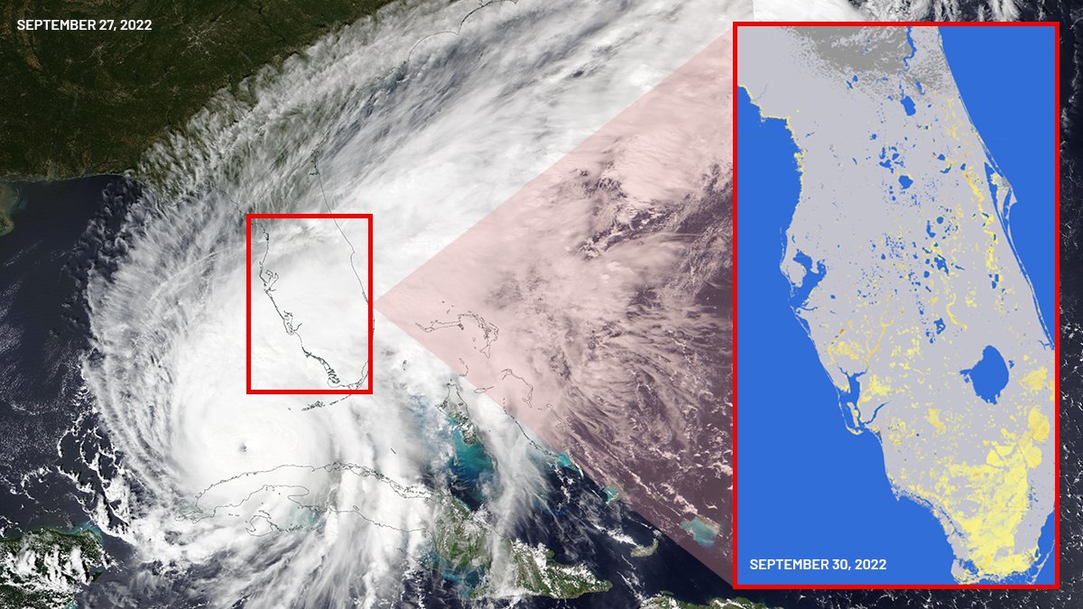
Experts use NOAA's JPSS satellite data to monitor floods & forecast hurricanes.

For example, the satellite captured Hurricane Ian on Sept. 27, 2022. A related flood map from Sept. 30, 2022, utilizing JPSS data, highlighted extensive flooding in Florida, shown in yellow.

Experts use @NOAA's JPSS satellite data to monitor floods & forecast hurricanes. For example, the #NOAA20 satellite captured Hurricane Ian on Sept. 27, 2022. A related flood map from Sept. 30, 2022, utilizing JPSS data, highlighted extensive flooding in Florida, shown in yellow.
account_circle
L3Harris(@L3HarrisTech) 's Twitter Profile Photo

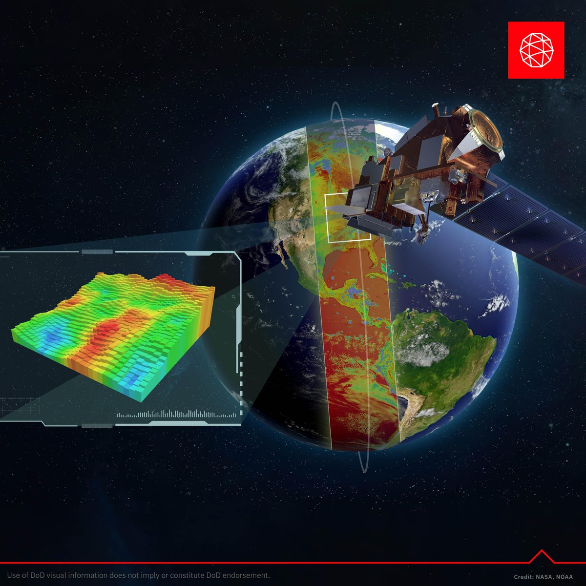
Our Crosstrack Infrared Sounder (CrIS) has successfully completed electromagnetic interference testing, ensuring it can provide data about our atmosphere, oceans and landscape from the harsh electromagnetic environment of space. bit.ly/3PWwBGE

Our Crosstrack Infrared Sounder (CrIS) has successfully completed electromagnetic interference testing, ensuring it can provide data about our atmosphere, oceans and landscape from the harsh electromagnetic environment of space. bit.ly/3PWwBGE #SpaceSymposium
account_circle
NOAA Satellites(@NOAASatellites) 's Twitter Profile Photo

Time for a Wednesday quiz! 🗺️🔍

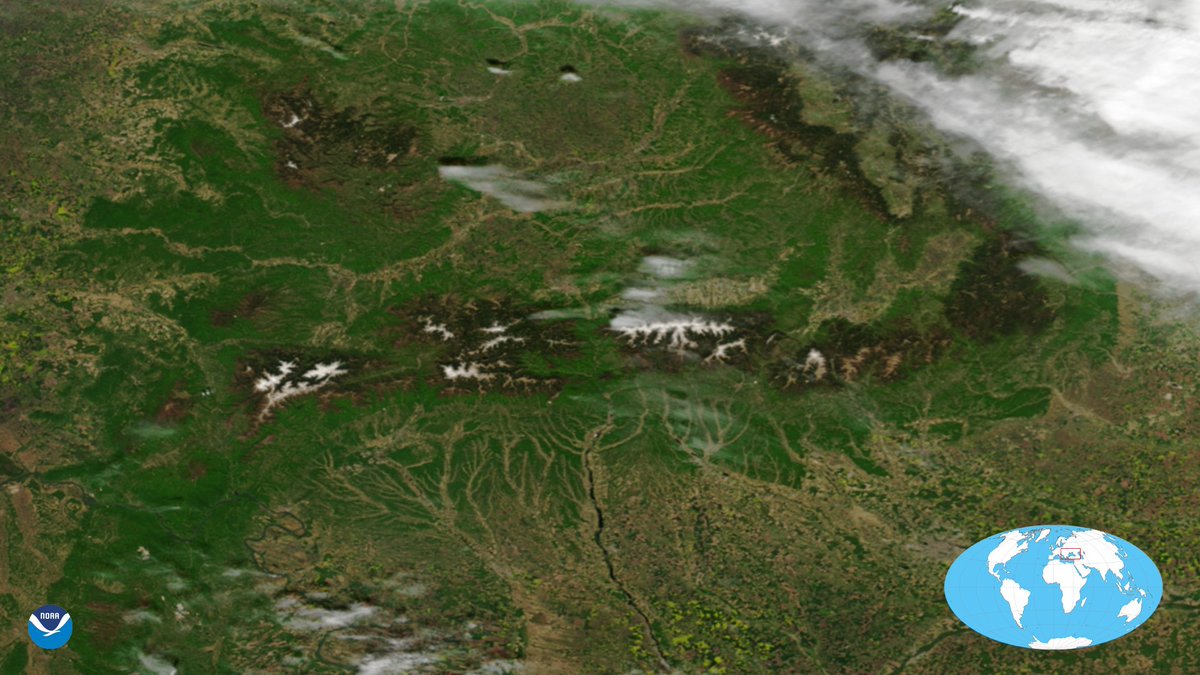
Yesterday, the 🛰️ had a beautiful view of this group of mountain ranges located in southern Romania. This group is part of a larger mountain range that forms an arc across Central Europe.

Time for a #WhereInTheWorld Wednesday quiz! 🗺️🔍 Yesterday, the #NOAA20 🛰️ had a beautiful view of this group of mountain ranges located in southern Romania. This group is part of a larger mountain range that forms an arc across Central Europe.
account_circle
UW-Madison CIMSS(@UWCIMSS) 's Twitter Profile Photo

This satellite image acquired overnight showcases some cool features uniquely revealed by Day Night Band:
1) the !
2) snow capped mountains illuminated by Aurora light
3) moon-lit cloud tops and a Pacific Low
cimss.ssec.wisc.edu/viirs/imagery-… What's not to love?

This satellite image acquired overnight showcases some cool features uniquely revealed by #VIIRS Day Night Band: 1) the #AuroraBorealis! 2) snow capped mountains illuminated by Aurora light 3) moon-lit cloud tops and a Pacific Low cimss.ssec.wisc.edu/viirs/imagery-… What's not to love?
account_circle
Joint Polar Satellite System (JPSS)(@JPSSProgram) 's Twitter Profile Photo

View changes in Earth's ozone with NOAA/NASA satellite data from Nov. 1, 2023, to April 13, 2024.

Enhanced colors show ozone amounts: purples and blues for lower, yellows and reds for higher.

This layer protects against the Sun's harmful UV-B radiation.

account_circle
UW-Madison CIMSS(@UWCIMSS) 's Twitter Profile Photo

Visible images showed an Arctic low that was bringing strong westerly winds to parts of the North Slope of Alaska: cimss.ssec.wisc.edu/satellite-blog……

account_circle
Joint Polar Satellite System (JPSS)(@JPSSProgram) 's Twitter Profile Photo

This animation, based on satellite data, displays Earth's sea surface temperatures (SST) as of April 9, 2024. 🌡️

SST data aids scientists in forecasting weather, understanding marine ecosystems, and predicting extreme weather to protect coastal communities.

account_circle
Joint Polar Satellite System (JPSS)(@JPSSProgram) 's Twitter Profile Photo

Track ocean health with NOAA’s JPSS satellites by observing phytoplankton blooms, which are a food source for a variety of marine life.

View this NOAA/NASA satellite image from Jan 10, 2024, of a bloom off Australia’s southern coast. 🔎

More: go.nasa.gov/48xtXys

Track ocean health with NOAA’s JPSS satellites by observing phytoplankton blooms, which are a food source for a variety of marine life. View this @NOAA/@NASA #SuomiNPP satellite image from Jan 10, 2024, of a bloom off Australia’s southern coast. 🔎 More: go.nasa.gov/48xtXys
account_circle
Joint Polar Satellite System (JPSS)(@JPSSProgram) 's Twitter Profile Photo

As approaches, get ready for a special week with NOAA's JPSS satellites. Each day this week, discover how they monitor ocean health and temperature, the ozone layer, wildfires and air quality, floods, weather, and vegetation.

Today, we're focusing on Earth’s ocean! 🌊

account_circle
NOAA Satellites(@NOAASatellites) 's Twitter Profile Photo

It's Wednesday, so it's time for a new quiz! 🥳

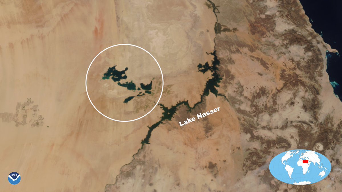
On April 8, the satellite caught a clear view of these lakes (circled), located near the Nile River in Egypt. Their presence is caused by the periodic overflow of Lake Nasser, located next to them.

It's #WhereInTheWorld Wednesday, so it's time for a new quiz! 🥳 On April 8, the #NOAA20 satellite caught a clear view of these lakes (circled), located near the Nile River in Egypt. Their presence is caused by the periodic overflow of Lake Nasser, located next to them.
account_circle
Joint Polar Satellite System (JPSS)(@JPSSProgram) 's Twitter Profile Photo

Take a look at the satellite’s view of the solar eclipse from yesterday! 🛰️✨

A shadow cast by the April 8, 2024, total solar can be seen as a dark stripe over Eastern North America.

Take a look at the #NOAA20 satellite’s view of the solar eclipse from yesterday! 🛰️✨ A shadow cast by the April 8, 2024, total solar #eclipse can be seen as a dark stripe over Eastern North America.
account_circle
NOAA Satellites(@NOAASatellites) 's Twitter Profile Photo

We're streaming our coverage live from the Dallas Cotton Bowl® Stadium!

Tune in to watch special guests and experts from NOAA, NSF, and NASA talk about the eclipse, space weather, and why we study the sun. twitter.com/i/broadcasts/1…

account_circle
Joint Polar Satellite System (JPSS)(@JPSSProgram) 's Twitter Profile Photo

As today's total solar occurs, we're noting its path of totality compared to 2017's across North America, where NOAA/NASA's satellite captured the eclipse's shadow over the southeastern U.S.

Stay tuned to see how NOAA’s JPSS satellites capture the event! 🛰️

As today's total solar #eclipse occurs, we're noting its path of totality compared to 2017's across North America, where @NOAA/@NASA's #SuomiNPP satellite captured the eclipse's shadow over the southeastern U.S. Stay tuned to see how NOAA’s JPSS satellites capture the event! 🛰️
account_circle
Joint Polar Satellite System (JPSS)(@JPSSProgram) 's Twitter Profile Photo

Join NOAA's JPSS satellites in observing Earth on the day of the April 8, 2024, eclipse. Share your cloud photos with The GLOBE Program to celebrate Month!

Join in by recording your observations with the GLOBE Observer app! ☁️📸

Learn more: observer.globe.gov/do-globe-obser…
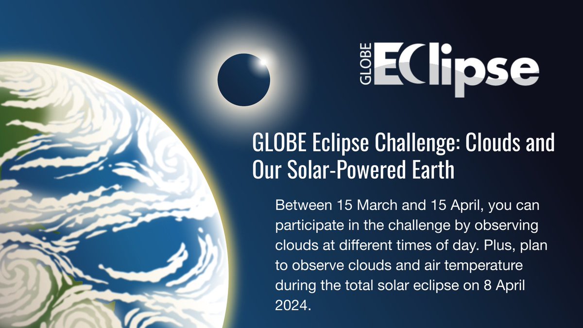
Join @NOAA's JPSS satellites in observing Earth on the day of the April 8, 2024, eclipse. Share your cloud photos with @GLOBEProgram to celebrate #CitizenScience Month! Join in by recording your observations with the GLOBE Observer app! ☁️📸 Learn more: observer.globe.gov/do-globe-obser…
account_circle
Joint Polar Satellite System (JPSS)(@JPSSProgram) 's Twitter Profile Photo

Gear up for the April 8, 2024, total solar eclipse during month!

On Oct. 14, 2023, the NOAA/NASA satellite captured an eclipse shadow over North & South America, while a NASA citizen scientist in Albuquerque, NM took a photo from the ground. 📸🛰️

Gear up for the April 8, 2024, total solar eclipse during #CitizenScience month! On Oct. 14, 2023, the @NOAA/@NASA #SuomiNPP satellite captured an eclipse shadow over North & South America, while a NASA citizen scientist in Albuquerque, NM took a photo from the ground. 📸🛰️
account_circle