Types Of #RemoteSensing - #Devices And Their #Applications [broad #overview ]
-
eos.com/blog/types-of-…
-
#GIS #spatial #mapping #earthobservation #tutorial #satellite #sensors #usecase #appliedscience #RADARSAT #TerraSARX #SRTM , #EOSDA #ERS #Sentinel #LANDSAT #insar #ifsar #LiDAR
![Greg Cocks 🇺🇦 (@gregcocks_kiwi) on Twitter photo 2024-04-30 02:18:27 Types Of #RemoteSensing - #Devices And Their #Applications [broad #overview]
-
eos.com/blog/types-of-…
-
#GIS #spatial #mapping #earthobservation #tutorial #satellite #sensors #usecase #appliedscience #RADARSAT #TerraSARX #SRTM, #EOSDA #ERS #Sentinel #LANDSAT #insar #ifsar #LiDAR Types Of #RemoteSensing - #Devices And Their #Applications [broad #overview]
-
eos.com/blog/types-of-…
-
#GIS #spatial #mapping #earthobservation #tutorial #satellite #sensors #usecase #appliedscience #RADARSAT #TerraSARX #SRTM, #EOSDA #ERS #Sentinel #LANDSAT #insar #ifsar #LiDAR](https://pbs.twimg.com/media/GMYPa3ZXwAAQ7Oc.jpg)

[NEW MILESTONE] PROMÉTHÉE Earth Intelligence, the French NewSpace operator of #EarthObservation #NanoSatellites , has reserved Zephyr launches 🚀🛰️🌍🛰️ This marks our first private commercial agreement following selection by CNES & Gouvernement ✅
![Latitude (@Latitude_eu) on Twitter photo 2024-04-29 12:25:26 [NEW MILESTONE] @PROMETHEE_Space, the French NewSpace operator of #EarthObservation #NanoSatellites, has reserved Zephyr launches 🚀🛰️🌍🛰️ This marks our first private commercial agreement following selection by @CNES & @gouvernementFR ✅ [NEW MILESTONE] @PROMETHEE_Space, the French NewSpace operator of #EarthObservation #NanoSatellites, has reserved Zephyr launches 🚀🛰️🌍🛰️ This marks our first private commercial agreement following selection by @CNES & @gouvernementFR ✅](https://pbs.twimg.com/media/GMVQ90jXQAAGFt9.jpg)

Exciting news!
We are thrilled to announce that our abstract has been accepted for IAC2024. Can't wait to share our insights and innovations with the global space community in Milan. See you there!
Authors: Nishq Ravindranath Preetham Akula
#IAC2024 #akulatech #earthobservation


🌱 Excited to share my latest project mapping drought in Kenya using satellite imagery & the Vegetation Condition Index ( #VCI ) with Earth Observation tools like Google Earth Engine! 🛰️🌍 J. #Kenya #ClimateChange #DroughtMapping #RemoteSensing #EarthObservation #GoogleEarthEngine

ガザの沖合に妙に細長い船がいます。31.5616,34.31901地点。
Check this out sentinelshare.page.link/Tp5Z #Sentinel -2 #Copernicus #EOBrowser #EarthObservation #RemoteSensing

Scott Herman from Maxar Technologies sharing how resolution and the narrative matters in site monitoring.
#earthobservation #sitemonitoring #analysis


Just launched: SkyFi's latest analytics tool with Satim Inc. 🛰️ Spot and classify maritime vessels like never before! 🚢 Check it out 👉 app.skyfi.com/insights/vesse… #earthobservation #geospatial #analytics #maritimesecurity

🌍 EO curiosities 🔍
📌Earth Observation of wildfires worldwide through satellite images allowed scientists to conclude that this is becoming more often and spreading further, giving a more detailed look.
esa.int/Applications/O…
#innovation #EarthObservation #horizoneu

🌏🛰️ What does the future of #Earthobservation science look like?
It's out of this world! With USGS Landsat Next launching in 2030 and partnering with NASA and @USGS, we're building the future of #EO science from ground stations to satellites, to processing and applying EO data.
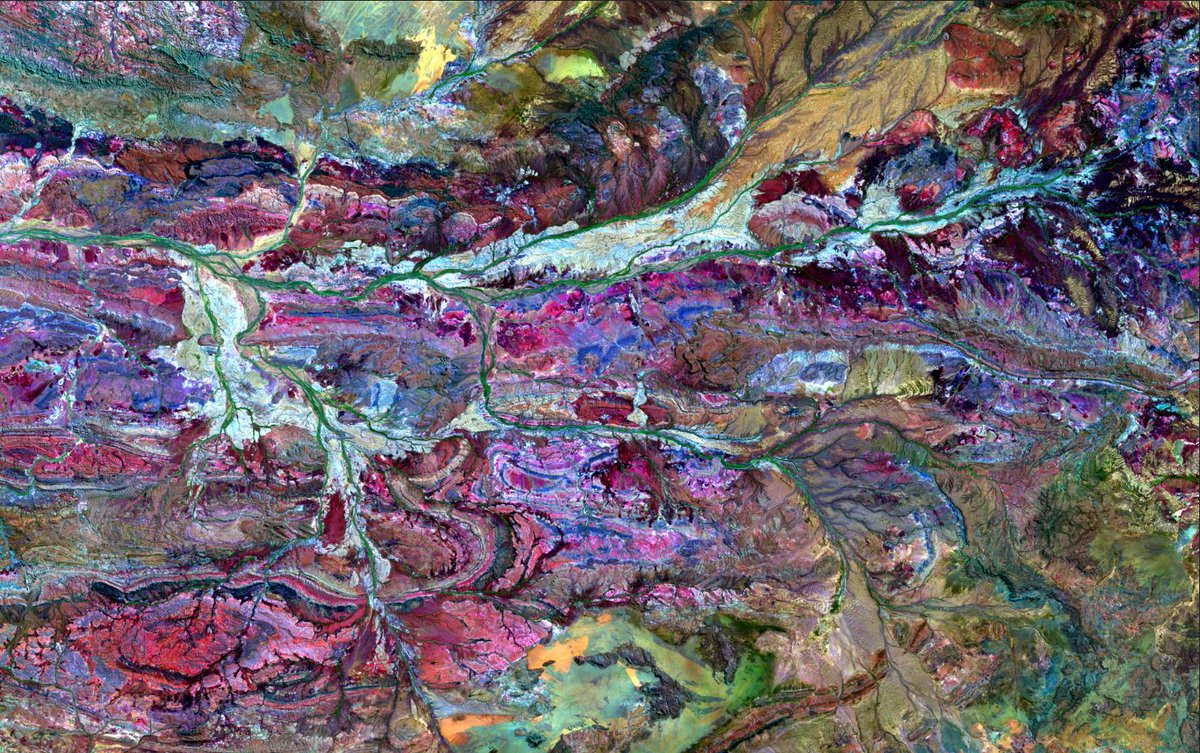

Early Estimates Of #Exotic Annual #Grass ( #EAG ) In The #Sagebrush #Biome , #USA , 2024 (ver. 1.0, April 2024)
-
doi.org/10.5066/P9351Z…
-
#RemoteSensing #GIS #spatial #Mapping #earthobservation #opendata #invasivespecies #vegetation #NDVI #USWest #landmanagement
USGS USGS_EROS


I am having a great time at IEEE IGARSS presenting my work on #lichen mapping using #Earthobservation and #MachineLearning ! #IGARSS2023


Did you know that our #EarthObservation datacenter provides a wealth of valuable data, ranging from dekad, monthly, to weekly intervals? Whether you're a researcher, policymaker, or an enthusiast, leverage climate data for effective decisions and actions.


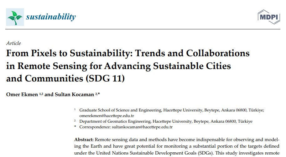
Our paper on the contribution of #remotesensing & #earthobservation to #UN #SDGs 11 is now online: mdpi.com/2071-1050/15/2…

Our research on the contribution of #remotesensing and #EarthObservation to UN SDGs is now online authors.elsevier.com/sd/article/S11…


Wildlife from space: Winners of Satellites for Biodiversity Award named #satellitedata #earthobservation #conservation #biodiversity
news.mongabay.com/2024/04/wildli…

🛰️How can #EarthObservation ensure a sustainable future for water resources?
We have developed a Roadmap to guide the evolution of Copernicus EU Programme for #water and advance towards a global understanding of the water cycle.
👉Discover more waterforce.eu/roadmap ESA Earth Observation

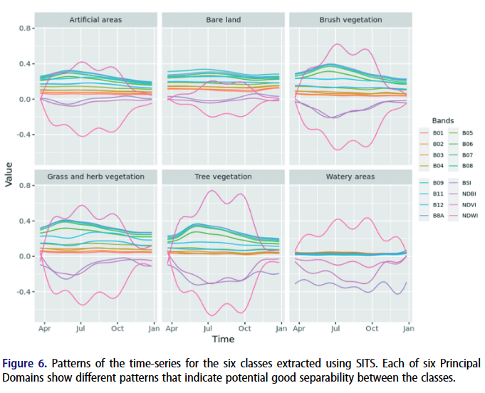
📢Time-first approach for #landcover mapping using big #Earthobservation data time-series in a #datacube – a case study from the Lake Geneva region ( #Switzerland ) by Gregory Giuliani
🌻Article link: doi.org/10.1080/209644…… #landuse #Sentinel2 #bigdata Gregory Giuliani

NASA's Tom & Jerry satellites formally known as the GRACE-FO mission chase each other around Earth precisely measuring their distance apart to monitor subtle variations in Earth's gravitational field.
#NASA #GRACEFO #Satellites #SpaceScience #EarthObservation #hexamap #esri #hank

