Katy Gardner
@katygard
Stream Ecologist & PhD candidate in Watershed Sciences
// studying stream bugs and salts
(she/her)
ID: 108133733
24-01-2010 23:49:32
693 Tweet
341 Followers
265 Following
 's Twitter Profile Photo")
 's Twitter Profile Photo")
 on Twitter photo Your timeline has been visited by the Solstice Salamander. Please plan accordingly.")
 on Twitter photo forget elf on the shelf, we've got ...")
 's Twitter Profile Photo")
 on Twitter photo This is impressive this deep into the season. We’re essentially at mid-February snowpack levels for most basins. Still, I want more.")
 's Twitter Profile Photo")
 's Twitter Profile Photo")
 's Twitter Profile Photo")
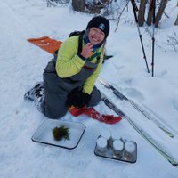
 on Twitter photo another year of winter fieldwork done, same 4 pairs of pants barely keeping me warm enough to stand it!")
 's Twitter Profile Photo")
 on Twitter photo NEW RECORD: It's official. SNOTEL weather stations reached an average of 26.1 inches. This year now appears to have the largest snowpack since 1952, and in case you haven't notice, it's STILL snowing! Chart here: bit.ly/3ZeKUID #utwx")
 's Twitter Profile Photo")
 on Twitter photo 🤯New SWE numbers just came in, and we have now received the most snow water equivalent since automated records started in 1981. Manual records go back to 1920, and according to <a href=\"/NRCS_Utah/\">NRCS Utah</a> this is the largest SWE since 1952 (with more snow to come). #utwx")
 on Twitter photo back to processing samples after a long break from the scope")
 's Twitter Profile Photo")
 on Twitter photo Three of the most terrifying graphs on the internet right now.")
 's Twitter Profile Photo")
@katygard
Stream Ecologist & PhD candidate in Watershed Sciences
// studying stream bugs and salts
(she/her)
ID: 108133733
24-01-2010 23:49:32
693 Tweet
341 Followers
265 Following