Christine Loughlin
@Cloughlinvt
Scientific & Technical Officer @MarineInst marine research infrastructures team || physical oceanographer, microplastics researcher
ID:30754307
13-04-2009 00:00:12
1,1K Tweets
328 Followers
466 Following
 's Twitter Profile Photo")
🇺🇸🇮🇪The United States Ambassador to Ireland, Claire Cronin Ambassador Claire Cronin visited the Marine Institute’s national headquarters in Galway, today. The Ambassador’s visit celebrates the strong ties in ocean science and technology that exist between the two nations that are separated…
 on Twitter photo 2024-04-05 08:40:55 🇺🇸🇮🇪The United States Ambassador to Ireland, Claire Cronin @USAmbIreland visited the Marine Institute’s national headquarters in Galway, today. The Ambassador’s visit celebrates the strong ties in ocean science and technology that exist between the two nations that are separated…")
 's Twitter Profile Photo")
Big thanks to Marine Institute's Felicity Donnelly for leading the AMRIT communications.
👏👏👏
 's Twitter Profile Photo")
🌊Interested to see #StormKathleen approach #Ireland ? You can view real time wave height and tide gauge water level here 👉digitalocean.ie. Stay safe at sea and in coastal regions!
#IMDBON : marine.ie/site-area/data…
#INTGN : marine.ie/site-area/data…
#SeaSafety #OceanObs
 on Twitter photo 2024-04-04 14:30:05 🌊Interested to see #StormKathleen approach #Ireland? You can view real time wave height and tide gauge water level here 👉digitalocean.ie. Stay safe at sea and in coastal regions! #IMDBON: marine.ie/site-area/data… #INTGN: marine.ie/site-area/data… #SeaSafety #OceanObs")
![[JOB OPPORTUNITIES] 2️⃣ vacancies with us at the moment. Click bit.ly/3PYWLGa for all the details. 🔵Administrative Assistant - Our Shared Ocean. Closing date: 📅 February 28, 2024 🔵Team Leader - EU Project Delivery. Closing date: 📅March 7, 2024 #Marine #Job](https://pbs.twimg.com/media/GHRsiC7XsAAhcdX.jpg "Marine Institute (@MarineInst) on Twitter photo 2024-02-26 16:28:35 [JOB OPPORTUNITIES] 2️⃣ vacancies with us at the moment. Click bit.ly/3PYWLGa for all the details. 🔵Administrative Assistant - Our Shared Ocean. Closing date: 📅 February 28, 2024 🔵Team Leader - EU Project Delivery. Closing date: 📅March 7, 2024 #Marine #Job")
 's Twitter Profile Photo")
#MeetTheFleet
Tom Crean is a 52.8m state of the art silent research vessel and can cater for 26 people over 21-days. It's equipped with a range of advanced technology for multi-purpose research.
Learn more here : bit.ly/3UC4tvB
Dept. Environment, Climate and Communications Geological Survey IE Marine Institute
 on Twitter photo 2024-02-12 08:00:09 #MeetTheFleet Tom Crean is a 52.8m state of the art silent research vessel and can cater for 26 people over 21-days. It's equipped with a range of advanced technology for multi-purpose research. Learn more here : bit.ly/3UC4tvB @Dept_ECC @GeolSurvIE @MarineInst")
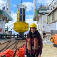
 on Twitter photo 2024-02-11 16:45:01 👩🔬#WomenInScience 🔬 - Christine Loughlin @Cloughlinvt #mara #eolaí #taighde")
 on Twitter photo 2024-01-02 10:17:54 Wishing you all a very Happy New Year! Start off 2024 using our Marine Research Infrastructure calendar free to download! marine.ie/sites/default/…")
 's Twitter Profile Photo")
🪸🐟Did you know Ireland has cold water corals? On Monday's 10ThingstoKnowAbout About, Erica Krueger Erica Terese Krueger tells Kathriona Devereux about these amazing creatures & we're on board #RVCelticVoyager with Samantha Hallam to talk all things #oceansandclimate
📺Mon 11th Dec 8.30pm RTÉ One…
The final INFOMAR Bluescale Series Map is the iconic Aran Islands off Co. #Galway !
📢 We are also delighted to announce that this map, and the entire Blue Scale Series are now available as Gaeilge 📢
Leagan Gaeilge ☘️ bit.ly/3Nhqf3E
Dept. Environment, Climate and Communications Geological Survey IE Marine Institute
 on Twitter photo 2023-12-08 08:01:33 The final INFOMAR Bluescale Series Map is the iconic Aran Islands off Co. #Galway! 📢 We are also delighted to announce that this map, and the entire Blue Scale Series are now available as Gaeilge 📢 Leagan Gaeilge ☘️ bit.ly/3Nhqf3E @Dept_ECC @GeolSurvIE @MarineInst")
Revealing the cover of our 2024 Marine Research Infrastructures calendar feat. our winning photo by Seán De Hoichtúin 🧭 of #SkelligMichael during an INFOMAR survey on Marine Institute Research Vessels #TomCrean . Stay turned in the new year for the launch of the calendar!
Marine Institute #2024MRIComp
 on Twitter photo 2023-12-07 14:00:00 Revealing the cover of our 2024 Marine Research Infrastructures calendar feat. our winning photo by @Seaniesan of #SkelligMichael during an @followtheboats survey on @RVMarineInst #TomCrean. Stay turned in the new year for the launch of the calendar! @MarineInst #2024MRIComp")
While at sea, you're treated to unspoiled views of the horizon like this one captured by Erica Terese Krueger during the PORO-CLIM survey on #RVCelticExplorer . We like to think this is what #IMDBON #M6 data buoy sees 99% of the time... although our data will tell us otherwise!!
#2024MRIComp
 on Twitter photo 2023-12-06 11:00:00 While at sea, you're treated to unspoiled views of the horizon like this one captured by @etk89 during the @ClimPoro survey on #RVCelticExplorer. We like to think this is what #IMDBON #M6 data buoy sees 99% of the time... although our data will tell us otherwise!! #2024MRIComp")
Declan Moran's perspective from #HighIsland in #Galway brings to mind the importance of #MarineResearchInfrastructure providing vital sea safety information and tide forecasting from our data buoys #IMDBON , wave buoys, and Tide Gauges #INTGN .
#2024MRIComp
 on Twitter photo 2023-12-05 16:30:00 Declan Moran's perspective from #HighIsland in #Galway brings to mind the importance of #MarineResearchInfrastructure providing vital sea safety information and tide forecasting from our data buoys #IMDBON, wave buoys, and Tide Gauges #INTGN. #2024MRIComp")
 's Twitter Profile Photo")
 on Twitter photo 2023-12-01 22:28:03 EIRSAT-1 SIGNAL RECEIVED!")
INFOMAR Bluescale Series Map #16 is #Dublin Bay!
From Captain Bligh to Ireland's Eye, this seabed is steeped in a rich maritime history, navigational hazards and tragic sinkings. This is one for the wall.
HD Download📷bit.ly/3qpT5Xd
Dept. Environment, Climate and Communications Geological Survey IE Marine Institute
 on Twitter photo 2023-11-24 13:09:25 INFOMAR Bluescale Series Map #16 is #Dublin Bay! From Captain Bligh to Ireland's Eye, this seabed is steeped in a rich maritime history, navigational hazards and tragic sinkings. This is one for the wall. HD Download📷bit.ly/3qpT5Xd @Dept_ECC @GeolSurvIE @MarineInst")
 's Twitter Profile Photo")
The Final General Assembly of the JERICO Design project ( #JERICO_DS ), gets underway this week at TalTech Division of Marine Physics, Tallinn, Estonia.
The project is led by Ifremer 🌊.
jerico-ri.eu/projects/jeric…
 on Twitter photo 2023-11-22 14:39:41 The Final General Assembly of the JERICO Design project (#JERICO_DS), gets underway this week at @MarineSys_est, Tallinn, Estonia. The project is led by @Ifremer_fr. jerico-ri.eu/projects/jeric…")
We’re at the JERICO Research Infrastructure #design final general assembly in #Tallinn , Estonia TalTech - Tallinn University of Technology. Marine Institute team member, Paul, gives updates on the work towards the JERICO Research Infrastructure sustainability plan for #coastalobservatories .
 on Twitter photo 2023-11-21 14:26:02 We’re at the @JERICORI #design final general assembly in #Tallinn, Estonia @TallinnTech. @MarineInst team member, Paul, gives updates on the work towards the @JERICORI sustainability plan for #coastalobservatories.")
#INFOMAR Bluescale Series Map #14 - Carnsore Point is here!
Trace the golden beaches of #Wexford or dive into the strong currents and dynamic #sandwaves off Carnsore Point, Tuskar Rock and #RosslareHarbour !
Dept. Environment, Climate and Communications Geological Survey IE Marine Institute
 on Twitter photo 2023-11-10 08:00:50 #INFOMAR Bluescale Series Map #14 - Carnsore Point is here! Trace the golden beaches of #Wexford or dive into the strong currents and dynamic #sandwaves off Carnsore Point, Tuskar Rock and #RosslareHarbour! @Dept_ECC @GeolSurvIE @MarineInst")
 's Twitter Profile Photo")
#30DayMapChallenge Day 9 - Hexagons
3D City Map of Galway 🇮🇪
Created using data from OpenStreetMap 🌍
#ireland #galway #gis #cartography #b3d
 on Twitter photo 2023-11-09 09:17:58 #30DayMapChallenge Day 9 - Hexagons 3D City Map of Galway 🇮🇪 Created using data from @openstreetmap 🌍 #ireland #galway #gis #cartography #b3d")
#30DayMapChallenge Day 7 - Navigation
Nautical Chart of The Aran Islands 🇮🇪⚓️
Drawn using INFOMAR (INFOMAR) data. Based off traditional UKHO charts.
Very far from complete - nautical charts are incredibly detailed! A work in progress.
#gis #ireland #cartography
 on Twitter photo 2023-11-07 09:15:18 #30DayMapChallenge Day 7 - Navigation Nautical Chart of The Aran Islands 🇮🇪⚓️ Drawn using INFOMAR (@followtheboats) data. Based off traditional UKHO charts. Very far from complete - nautical charts are incredibly detailed! A work in progress. #gis #ireland #cartography")
#30DayMapChallenge Day 3 - Polygons
Geological Map of Munster, Ireland 🇮🇪
Created using the excellent 500k series bedrock data from Geological Survey IE ⚒️ Great source for open access data for a broad range of themes!
#ireland #gis #cartography #qgis #blender
 on Twitter photo 2023-11-03 12:30:20 #30DayMapChallenge Day 3 - Polygons Geological Map of Munster, Ireland 🇮🇪 Created using the excellent 500k series bedrock data from @GeolSurvIE ⚒️ Great source for open access data for a broad range of themes! #ireland #gis #cartography #qgis #blender")