Remote Sensing @ WSL
@wsl_remotesens
Remote sensing groups @WSL_research and @SLFDavos
Extracting information using a variety of platforms and sensors
ID: 1334175686291054595
https://www.wsl.ch/en/about-wsl/organisation/research-units/land-change-science/remote-sensing.html 02-12-2020 16:43:05
128 Tweet
815 Followers
53 Following
 's Twitter Profile Photo")
The keynotes will also be joined by Laura Duncanson @tommaso_jucker Atticus Stovall Dr. Joanne C. White + others from World Bank @WSL_research University of Helsinki Cambridge Geography and expertly chaired by @emilyrlines @stefanopuliti Mathias Disney and Andy Burt Sylvera
 on Twitter photo Crumbling Piz Buin Pitschen: Mapping slope instabilities for risk assessment in a breath-taking landscape! #CERC
@SLFDavos @WSL_research <a href=\"/DamesOfDrones/\">DamesOfDrones</a> <a href=\"/Wingtra/\">Wingtra</a>")
 's Twitter Profile Photo")
 's Twitter Profile Photo")
International Tree Mortality Network Thanks to amazing data contributors, the first version of the database on insect and disease disturbance in European forests (DEFID2) is now online - read all about it in the open access paper onlinelibrary.wiley.com/doi/full/10.11…
 's Twitter Profile Photo")
Great forest workshop today Esri Schweiz in Zurich. I was invited to present our latest #forest research from Remote Sensing @ WSL . Interesting presentations, good mix of the audience and a rich apéro 👍 esri.ch/de-ch/events/a…
Wanna join our team? Open internship position for 6 months Remote Sensing @ WSL dealing with an intriguing topic: Light emissions and remote sensing. apply.refline.ch/273855/1593/pu…
 on Twitter photo Assessing the structure of #forest 🌳🌲edges is key for understanding their ecological value and supporting a purposive management. See the latest paper @MoBruggisser how to do it with standard leaf-off airborne laser scanning data:
doi.org/10.1016/j.ecol…")
 on Twitter photo Working on an exciting new topic on nighttime light (NTL) with high potential for ecological applications, #SDGSAT")
 's Twitter Profile Photo")
Exploring new horizons: tree species mapping with #deeplearning & #RGB imagery 🌲🌳🌱🌴Future #tree & #biodiversity monitoring methods 🧐 I'll be giving a workshop with James Ball at #ForestryAI If you are interested, join us 👩🏾💻🧑🏽💻👩💻⬇️ Registration: forestryai.website/events
 on Twitter photo Exploring new horizons: tree species mapping with #deeplearning & #RGB imagery 🌲🌳🌱🌴Future #tree & #biodiversity monitoring methods 🧐
I'll be giving a workshop with <a href=\"/JgcBall/\">James Ball</a> at #ForestryAI
If you are interested, join us 👩🏾💻🧑🏽💻👩💻⬇️
Registration: forestryai.website/events")
 's Twitter Profile Photo")
 on Twitter photo The abstract submission deadline for ForestSAT in Rotorua has been extended until 20 April.
This is your opportunity to present original research in the oral or poster format.
#ForestSAT #conference #abstracts #forestry #spatialanalysis
Submit now: buff.ly/3PxgK17")
 's Twitter Profile Photo")
 on Twitter photo #EGU24 kicked off in #Vienna - a homerun for our group, as always. This year, we're prominently featured in session BG9.2, focusing on RS for forest applications. Drop by and say hi Wednesday! 👋👇meetingorganizer.copernicus.org/EGU24/session/…")
 's Twitter Profile Photo")
You have airborne #lidar, now what to do? 🌲📏 Find guidance: Dr. Joanne C. White et al. A model development and application guide for generating an enhanced forest inventory using airborne laser scanning data and an area-based approach. #forestinventory 🔗publications.gc.ca/collections/co…
 on Twitter photo You have airborne #lidar, now what to do? 🌲📏
Find guidance:
<a href=\"/Joanne_C_White/\">Dr. Joanne C. White</a> et al. A model development and application guide for generating an enhanced forest inventory using airborne laser scanning data and an area-based approach. #forestinventory
🔗publications.gc.ca/collections/co…")
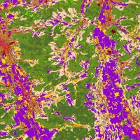
🌲🛰️🌳Do you know how to appropriately validate countrywide #forest disturbance maps? An extensive validation of generated maps is essential... Here we show how to do it: academic.oup.com/forestry/advan… #Sentinel2 Janik Deutscher Remote Sensing @ WSL @
 on Twitter photo 📢 Call for data! Seeking #RGBI imagery & annotations for #tree #species. 🌳🌲🌴Passionate about #forestry, #ecology, #biodiversity, or #DeepLearning? Help build a universal model for tree species #identification! ⌛️Deadline: 31.10.2024. ➡️ 3dforecotech.eu/activities/tre…")
 on Twitter photo Do practitioners correctly use your remote sensing based #forest #maps ? Help them to understand what they are meant for and what not! Make them part of it!
We had a successful workshop with feedback and got new reference data to further improve our maps.")