Tina Simpkin (@tsimpkin) 's Twitter Profile
Tina Simpkin

@tsimpkin

CBC Meteorologist BSc DMet MS

ID: 25928564

calendar_today23-03-2009 01:45:42

5,5K Tweet

5,5K Followers

963 Following

William Shatner (@williamshatner) 's Twitter Profile Photo

🤔 You know, we Canadians are the nicest, politest people on Earth...😇 ...things change. however when you threaten our f***ing wild salmon!!! 🤬 You get THIS! 👉🏻🖕🏼. Don't be a 🍆 be an 😇 and say #FckOffFishFarms #FOFF! Much Love, Bill the proud Canadian ❤️

Ryan Snoddon (@ryansnoddon) 's Twitter Profile Photo

Historic June day for the Halifax Metro area. 35.3° at Windsor Park is a new June record for the downtown area (records since 1871). 34.3° is a new June record for Halifax YHZ airport (records since 1953) Widespread temps in the 33° to 35° (Humidex values 40 to 43) #nsstorm

Historic June day for the Halifax Metro area.

35.3° at Windsor Park is a new June record for the downtown area (records since 1871).

34.3° is a new June record for Halifax YHZ airport (records since 1953)

Widespread temps in the 33° to 35°
(Humidex values 40 to 43)

#nsstorm
Thierry Goose (@thierrygoosebc) 's Twitter Profile Photo

1/2 Historic day in Eastern #Canada! Monthly records broken.👇 NL 🌡️35.4°C Terra Nova, all-time record tied & new June record for Newfoundland 🌡️33.7°C Gander 🌡️30.1°C St. John's NS 🌡️35.6°C Malay Falls 🌡️35.3°C Halifax Windsor Park 🌡️34.3°C Halifax YHZ 🌡️33.9°C Shearwater ...

1/2 Historic day in Eastern #Canada!

Monthly records broken.👇

NL
🌡️35.4°C Terra Nova, all-time record tied & new June record for Newfoundland
🌡️33.7°C Gander
🌡️30.1°C St. John's

NS
🌡️35.6°C Malay Falls
🌡️35.3°C Halifax Windsor Park
🌡️34.3°C Halifax YHZ
🌡️33.9°C Shearwater
...
Ryan Snoddon (@ryansnoddon) 's Twitter Profile Photo

Many June records were broken over the past 2 days across Atlantic Canada. All-time (warmest any month) records were also broken. On top of that, new June Provincial records were set in New Brunswick & PEI. H/T Thierry Goose Cape Breton Mesonet Patrick Duplessis Rodney Barney Extreme Temperatures Around The World
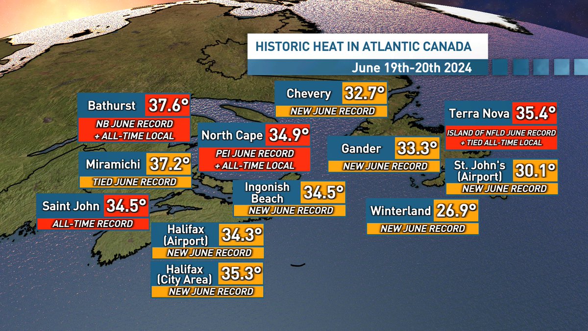
Many June records were broken over the past 2 days across Atlantic Canada. 
All-time (warmest any month) records were also broken. 
On top of that, new June Provincial records were set in New Brunswick & PEI.

H/T <a href="/ThierryGooseBC/">Thierry Goose</a> <a href="/CBmesonet/">Cape Breton Mesonet</a> <a href="/Pat_wx/">Patrick Duplessis</a> <a href="/rcbstormpost/">Rodney Barney</a> <a href="/extremetemps/">Extreme Temperatures Around The World</a>
Tina Simpkin (@tsimpkin) 's Twitter Profile Photo

Thunderstorms are rocking the NB Fundy coast. ECCC has issued a Severe T-Warning for Saint John Co. courtesy of these T-Storms producing torrential rain. Elsewhere the rain will be moving in from W to E with risks of thunderstorms today. #nbstorm #nsstorm #peistorm

Thunderstorms are rocking the NB Fundy coast. ECCC has issued a Severe T-Warning for Saint John Co. courtesy of these T-Storms producing torrential rain. Elsewhere the rain will be moving in from W to E with risks of thunderstorms today. #nbstorm #nsstorm #peistorm
Tina Simpkin (@tsimpkin) 's Twitter Profile Photo

ECCC has issued a severe thunderstorm watch for Cumberland county. These thunderstorms are capable of producing torrential rain in localized areas. Warnings are still in effect for the NB Fundy coast. #nbstorm #nsstorm

ECCC has issued a severe thunderstorm watch for Cumberland county. These thunderstorms are capable of producing torrential rain in localized areas. Warnings are still in effect for the NB Fundy coast. #nbstorm #nsstorm
Tina Simpkin (@tsimpkin) 's Twitter Profile Photo

There are no watches or warnings from ECCC right now. There are thunderstorms out there that are producing lightning as well has heavy rain. T-storms remain in the forecast today/evening. Stay weather aware today. Heavy rain is no fun to drive in. #nbstorm #nsstorm #peistorm

There are no watches or warnings from ECCC right now.  There are thunderstorms out there that are producing lightning as well has heavy rain. T-storms remain in the forecast today/evening. Stay weather aware today. Heavy rain is no fun to drive in. #nbstorm #nsstorm #peistorm
Tina Simpkin (@tsimpkin) 's Twitter Profile Photo

The first week of July will bring back the summertime heat. Skies will continue to clear from west to east and temperatures will soar into the upper 20's in the west. It will remain cooler along areas of the coast. #nsstorm #nbstorm #peistorm

The first week of July will bring back the summertime heat. Skies will continue to clear from west to east and temperatures will soar into the upper 20's in the west. It will remain cooler along areas of the coast. #nsstorm #nbstorm #peistorm
Tina Simpkin (@tsimpkin) 's Twitter Profile Photo

Watching Beryl. A major hurricane CAT5 in the Caribbean. Jamaica is under the gun with the potential of heavy flooding tomorrow. Beryl is expected to move into the Yucatan Peninsula by the end of the week.

Watching Beryl. A major hurricane CAT5 in the Caribbean. Jamaica is under the gun with the potential of heavy flooding tomorrow. Beryl is expected to move into the Yucatan Peninsula by the end of the week.
Tina Simpkin (@tsimpkin) 's Twitter Profile Photo

Happy Friday. Scattered showers this AM in the west with mild temps. More showers will develop this afternoon with T-Storms possible in NB. SAT more showers with risks of T-Storms. Slow clearing on SUN. #nsstorm #nbStorm #peistorm

Happy Friday. Scattered showers this AM in the west with mild temps.  More showers will develop this afternoon with T-Storms possible in NB. SAT more showers with risks of T-Storms. Slow clearing on SUN. #nsstorm #nbStorm #peistorm
Tina Simpkin (@tsimpkin) 's Twitter Profile Photo

Heavy rain is falling in Southern NB and N NS. The rain is persistent in PEI and Cape Breton. ECCC has issued a severe thunderstorm in S NB. Thunderstorms that do develop will produce torrential down pours along with lightning. #nbstorm #nsstorm

Heavy rain is falling in Southern NB and N NS. The rain is persistent in PEI and Cape Breton. ECCC has issued a severe thunderstorm in S NB. Thunderstorms that do develop will produce torrential down pours along with lightning.  #nbstorm #nsstorm
Tina Simpkin (@tsimpkin) 's Twitter Profile Photo

When this line of rain and thunderstorms moved through Fredericton 30-55+ mm fell. ECCC has extended the Severe Thunderstorm Watch into NS. Thunderstorms can produce locally heavier amounts of rain, lightning and gusty winds. #nsstorm #NBstorm

When this line of rain and thunderstorms moved through Fredericton 30-55+ mm fell. ECCC has extended the Severe Thunderstorm Watch into NS. Thunderstorms can produce locally heavier amounts of rain, lightning and gusty winds. #nsstorm #NBstorm
Tina Simpkin (@tsimpkin) 's Twitter Profile Photo

Stormy weather especially in Kings and Hants county. ECCC has issued a severe thunderstorm warning for both. Heavy rain and lightning is expected underneath these storms. A severe thunderstorm watch remains in effect as well as a rainfall warning. Be safe #nsstorm

Stormy weather especially in Kings and Hants county. ECCC has issued a severe thunderstorm warning for both. Heavy rain and lightning is expected underneath these storms. A severe thunderstorm watch remains in effect as well as a rainfall warning. Be safe #nsstorm
Tina Simpkin (@tsimpkin) 's Twitter Profile Photo

It is a stormy morning. ECCC has issued a Severe Thunderstorm Watch. This cluster of thunderstorms are producing heavy rain, lightning and gusty winds. The potential for 10-25 mm from these storms in a short period is high. #NSStorm #NBstorm

It is a stormy morning. ECCC has issued a Severe Thunderstorm Watch.  This cluster of thunderstorms are producing heavy rain, lightning and gusty winds. The potential for 10-25 mm from these storms in a short period is high. #NSStorm #NBstorm
Tina Simpkin (@tsimpkin) 's Twitter Profile Photo

A lot of rain is being produced by these thunderstorms. ECCC has issued a severe thunderstorm warning for Saint John County. A severe thunderstorm watch remains in effect for Cumberland and Kings County. #NBstorm #NSstorm

A lot of rain is being produced by these thunderstorms. ECCC has issued a severe thunderstorm warning for Saint John County.  A severe thunderstorm watch remains in effect for Cumberland and Kings County. #NBstorm #NSstorm
Tina Simpkin (@tsimpkin) 's Twitter Profile Photo

Right now the heavy rain is moving along the Fundy coast into N NS. ECCC has issued a Severe Thunderstorm Watch & expanded it into NB & SW NS. Remember a watch means conditions are favourable for Thunderstorms. Heavy rain and lightning will be the main threat with these storms.

Right now the heavy rain is moving along the Fundy coast into N NS. ECCC has issued a Severe Thunderstorm Watch &amp;  expanded it into NB &amp; SW NS. Remember a watch means conditions are favourable for Thunderstorms. Heavy rain and lightning will be the main threat with these storms.
Tina Simpkin (@tsimpkin) 's Twitter Profile Photo

Atlantic Canada will have to keep an eye on Ernesto. Right now a Tropical Storm but it is expected to travel towards the Maritimes by the weekend. Perhaps with Category 1 strength? #nsstorm #nbstorm #peistorm National Hurricane Center
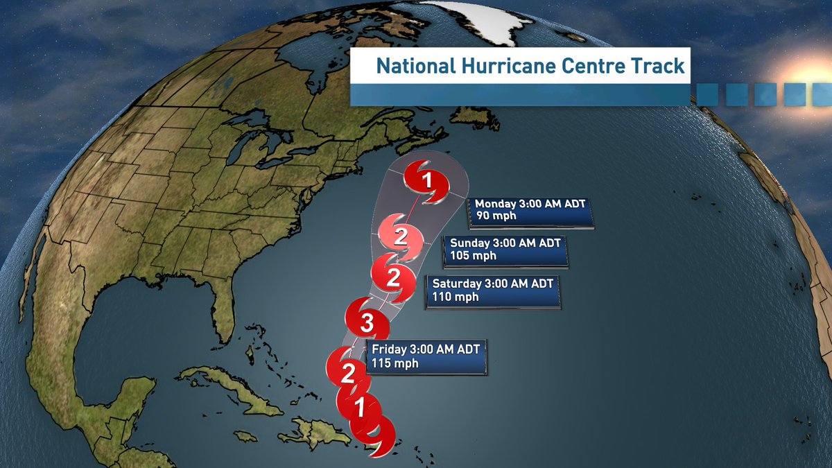
Atlantic Canada will have to keep an eye on Ernesto. Right now a Tropical Storm but it is expected to travel towards the Maritimes by the weekend. Perhaps with Category 1 strength? #nsstorm #nbstorm #peistorm <a href="/NHC_Atlantic/">National Hurricane Center</a>
Tina Simpkin (@tsimpkin) 's Twitter Profile Photo

Right now the National Hurricane Center has Ernesto becoming a Cat 3 , dissipating but still hanging on to Cat 1 strength as it heads towards NS. The track and strength may change between now and then. #nsstorm #nbstorm #peistorm (forecasted Sustained winds in km/h)
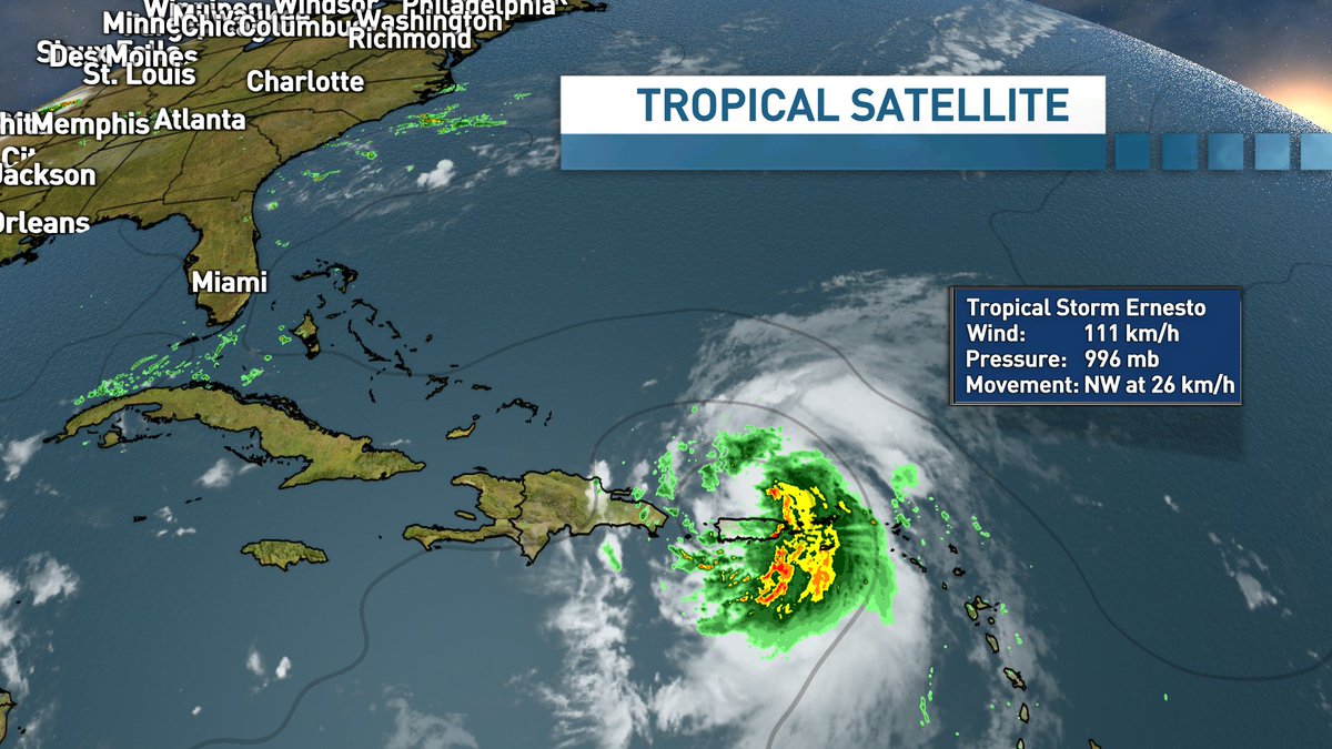
Right now the <a href="/NHC_Atlantic/">National Hurricane Center</a> has Ernesto becoming a Cat 3 , dissipating but still hanging on to Cat 1 strength as it heads towards NS.  The track and strength may change between now and then.   #nsstorm #nbstorm #peistorm (forecasted Sustained winds in km/h)