Connor Manning (@connor2n2o) 's Twitter Profile
Connor Manning

@connor2n2o

ID: 334779247

calendar_today13-07-2011 17:14:46

61 Tweet

163 Takipçi

86 Takip Edilen

Markus Schütz (@m_schuetz) 's Twitter Profile Photo

Potree also supports the entwine (EPT) format, an alternative to the PotreeConverter that supports >100 billion points, thanks to @[email protected] and @csmannin see: entwine.io Some impressive demos: usgs.entwine.io/# potree.entwine.io

Potree also supports the <a href="/entwineio/">entwine</a> (EPT) format, an alternative to the PotreeConverter that supports &gt;100 billion points, thanks to <a href="/howardbutler/">@hobu@fosstodon.org</a> and @csmannin 

see: entwine.io

Some impressive demos: 
usgs.entwine.io/# 
potree.entwine.io
Pete Gadomski (@petegadomski) 's Twitter Profile Photo

lidar 🔦 drones 🚁and vineyards 🍇 486 million points from three flights 0.034m vertical accuracy all in your browser thanks to entwine, PDAL, and #potree and thanks to Law Estates vineyards for letting us fly potree.entwine.io/data/lawestate…

lidar 🔦 drones 🚁and vineyards 🍇
486 million points from three flights
0.034m vertical accuracy
all in your browser
thanks to <a href="/entwineio/">entwine</a>, <a href="/pointcloudpipe/">PDAL</a>, and #potree
and thanks to Law Estates vineyards for letting us fly

potree.entwine.io/data/lawestate…
@hobu@fosstodon.org (@howardbutler) 's Twitter Profile Photo

View all 24 billion points of City of Hobbs mobile LiDAR in #potree at hobbslidar.com built using entwine and PDAL. Hobu, Inc. collaborated with Bohannan Huston, Inc to bring data from @Transcend_GIS to AWS for convenient public viewing and exploitation.

View all 24 billion points of <a href="/CityofHobbs/">City of Hobbs</a> mobile LiDAR in #potree at hobbslidar.com built using <a href="/entwineio/">entwine</a> and <a href="/pointcloudpipe/">PDAL</a>. Hobu, Inc. collaborated with <a href="/BohannanHuston/">Bohannan Huston, Inc</a> to bring data from @Transcend_GIS to AWS for convenient public viewing and exploitation.
entwine (@entwineio) 's Twitter Profile Photo

Entwine 2.1 is released. Faster indexing. Lower memory. Optional zstd encoding. Bug squashing. github.com/connormanning/… entwine.io/download.html and Conda Forge

entwine (@entwineio) 's Twitter Profile Photo

Don't miss @csmannin present "Continental Scale Point Cloud Data Management and Exploitation" at #FOSS4G2019 on this Friday at 1500 local (0900 EDT on the live stream at streaming.media.ccc.de ). #foss4g

entwine (@entwineio) 's Twitter Profile Photo

@csmannin's #FOSS4G2019 presentation is now online. Visit media.ccc.de/v/bucharest-12… to learn about using Entwine for point cloud data management.

SeanGorman (@seangorman) 's Twitter Profile Photo

Psyched to share the results of the pixel8earth experiment mapping Downtown Boulder in 3D - pixel8.earth. The data is available in PDAL .ept and Cesium 3D tiles as well as interactive maps you can explore.

pixel8earth (@pixel8earth) 's Twitter Profile Photo

The team is excited to share the results of our Boulder 3D mapping experiment. Check out the blog post on what we learned link.medium.com/WpuEgd2oY0 and access the open data at pixel8.earth

@hobu@fosstodon.org (@howardbutler) 's Twitter Profile Photo

USGS has continued to update and refresh the AWS Public Dataset with entwine EPT data. Practice virtually running from B to C at ORD using #potree and recently added Cook County IL #3DEP #lidar data in your browser. usgs.entwine.io/data/view.html…

<a href="/USGS/">USGS</a> has continued to update and refresh the AWS Public Dataset with <a href="/entwineio/">entwine</a> EPT data. Practice virtually running from B to C at ORD using #potree and recently added Cook County IL #3DEP #lidar data in your browser. usgs.entwine.io/data/view.html…
fosstodon.org/@klaskarlsson (@klaskarlsson) 's Twitter Profile Photo

Very impressive to be able to pull in huge online pointcloud datasets directly into QGIS 3.20. Data organized in EPT and served as JSON with http... Very impressive! entwine.io/entwine-point-… Thanks: Lutra Consulting Limited @[email protected]
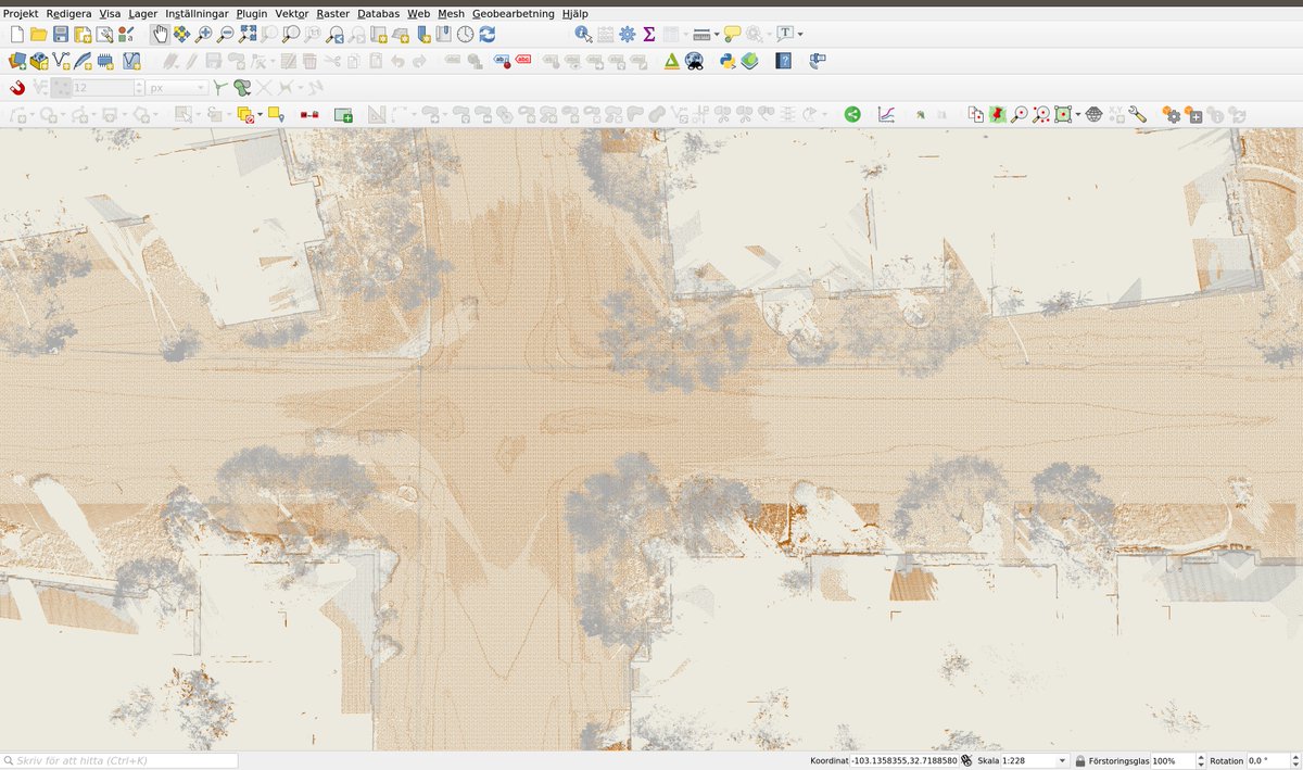
Very impressive to be able to pull in huge online pointcloud datasets directly into <a href="/QGIS/">QGIS</a> 3.20.
Data organized in EPT and served as JSON with http...

Very impressive!
entwine.io/entwine-point-…
Thanks: <a href="/lutraconsulting/">Lutra Consulting Limited</a> <a href="/howardbutler/">@hobu@fosstodon.org</a>
PDAL (@pointcloudpipe) 's Twitter Profile Photo

Data from @uoautzen is a Stanford bunny of #lidar data. Max Sampson from Hobu, Inc. recently labeled all 10 million points with 15 classifications for ML testing and training activities. You can see it online at autzen.entwine.io

Data from @uoautzen is a Stanford bunny of #lidar data. Max Sampson from Hobu, Inc. recently labeled all 10 million points with 15 classifications for ML testing and training activities. You can see it online at autzen.entwine.io
Tom Augspurger (@tomaugspurger) 's Twitter Profile Photo

Next up: USGS 3DEP Lidar! planetarycomputer.microsoft.com/dataset/group/… This was brought to the Planetary Computer by @[email protected], Connor Manning, and Kyle Mann. This dataset was a first in several ways.

Next up: USGS 3DEP Lidar! planetarycomputer.microsoft.com/dataset/group/…

This was brought to the Planetary Computer by <a href="/howardbutler/">@hobu@fosstodon.org</a>, <a href="/connor2n2o/">Connor Manning</a>, and Kyle Mann. This dataset was a first in several ways.
@hobu@fosstodon.org (@howardbutler) 's Twitter Profile Photo

Newly announced for #FOSS4G2022... viewer.copc.io now supports drag-n-drop of local copc.io files! Thanks Cameron and Connor Manning from the hobuinc team for the wizardry. Convert your data to COPC with PDAL or QGIS and share away!

Cole Speed (@colespeed) 's Twitter Profile Photo

Mind-blown by how easy it is to visualize USGS 3DEP lidar data with viewer.copc.io by Cameron & Connor Manning of hobuinc. ~5 min to convert LAZ to COPC with PDAL and drag/drop in the browser. Data from OpenTopography shows the Austin, TX skyline circa 2017

Mind-blown by how easy it is to visualize <a href="/USGS/">USGS</a> 3DEP lidar data with viewer.copc.io by <a href="/TheMrCam/">Cameron</a> &amp; <a href="/connor2n2o/">Connor Manning</a> of <a href="/hobuinc/">hobuinc</a>. ~5 min to convert LAZ to COPC with <a href="/pointcloudpipe/">PDAL</a> and drag/drop in the browser. Data from <a href="/OpenTopography/">OpenTopography</a> shows the Austin, TX skyline circa 2017
@hobu@fosstodon.org (@howardbutler) 's Twitter Profile Photo

Western FL USGS 3DEP lidar point clouds available in AWS Open Data at s3://usgs-lidar-public and viewable in your browser with address search 🔎 at viewer.copc.io/?state=5c94a64…

Western FL <a href="/USGS/">USGS</a> 3DEP lidar point clouds available in <a href="/AWSOpenData/">AWS Open Data</a> at s3://usgs-lidar-public and viewable in your browser with address search 🔎 at viewer.copc.io/?state=5c94a64…