Terraformed Mars
@terraformedmars
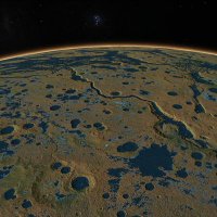
Bot by @cjhandmer publishes snippets of simulated terraformed Mars landscapes every six hours.
ID: 1079841016310460416
https://caseyhandmer.wordpress.com/2018/11/29/mars-global-hydrology-at-full-mola-resolution/ 31-12-2018 20:45:35
4,4K Tweet
1,1K Takipçi
2 Takip Edilen
 on Twitter photo")
 on Twitter photo")
 on Twitter photo")
 on Twitter photo")
 on Twitter photo")
 on Twitter photo")
 on Twitter photo")
 on Twitter photo")
 on Twitter photo")
 on Twitter photo")
 on Twitter photo")
All these images were rendered in about 2018. The next version, with 128x higher resolution, is a work in progress but I took a big step yesterday. Unfortunately GPT is still pretty useless at this kind of thing. CC Casey Handmer
 's Twitter Profile Photo")
Someone sent us a new Terraform Industries shirt based on Terraformed Mars imagery. Thank you!
 on Twitter photo Someone sent us a new <a href=\"/TerraformIndies/\">Terraform Industries</a> shirt based on <a href=\"/terraformedmars/\">Terraformed Mars</a> imagery. Thank you!")
 on Twitter photo I'm gearing up for the next phase of the hydrology simulation, to increase resolution from 462 m down to 7.2 m, and to do this I needed to fill in a mere 360 GB of topo data extending just 2 degrees out from each pole, but Mars 3 HD wasn't having it. Completely stuffed. Hard to")
 on Twitter photo Here are 3 screenshots from 3 different simulations and renders I've done, each with subtle differences in environmental parameters. The most recent run converged after 3 days so I'll be taking that dataset forward for the first higher resolution run.")
 on Twitter photo Let's zoom in on the newest dataset (hot off the presses this morning). We start from a distance: the red planet has a greenish tinge.
The red patch below is Hellas Basin - in this sim most water evaporates before reaching the lowest altitudes, similar to Death Valley and the")
 on Twitter photo <a href=\"/retrrtrarded/\">-oid vaporizer</a> Gotchu.")
 on Twitter photo @50SatMD It's the wrong file. I mean, the data is there but it doesn't play properly with Google Earth. Will fix. In the meantime, here's a different one.")