Direxion LETFs(@DirexionLETFs) 's Twitter Profile Photo

Traders - gain access to the stocks comprising S&P 500 Index (SPXT) with daily 3X and -3X leverage. Learn more about the $SPXL $SPXS ETFs from Direxion.

account_circle
NWS Baltimore-Washington(@NWS_BaltWash) 's Twitter Profile Photo

Looking ahead to tomorrow, severe thunderstorms return to the forecast! The primary threats will be damaging winds and large hail. Additionally, wildfire smoke should increase, mainly within the upper atmosphere.

Looking ahead to tomorrow, severe thunderstorms return to the forecast!  The primary threats will be damaging winds and large hail.  Additionally, wildfire smoke should increase, mainly within the upper atmosphere. #MDwx #VAwx #DCwx #WVwx
account_circle
Maryland Weather(@stateMDWX) 's Twitter Profile Photo

Severe Thunderstorm Watch 318 has been issued for Chesapeake Bay from Drum Point MD to Smith Point VA, Tangier Sound, Tidal Potomac from Key Bridge MD to Smith Point VA, until 9:00 PM EDT.

Severe Thunderstorm Watch 318 has been issued for Chesapeake Bay from Drum Point MD to Smith Point VA, Tangier Sound, Tidal Potomac from Key Bridge MD to Smith Point VA, until 9:00 PM EDT.
#DCwx #MDwx
account_circle
NWS Baltimore-Washington(@NWS_BaltWash) 's Twitter Profile Photo

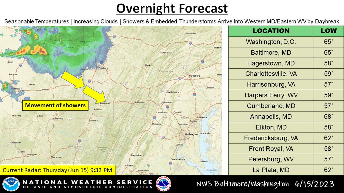
Temperatures will be milder tonight as clouds move in from the west. Showers and thunderstorms across the OH Valley will track toward western MD just before daybreak. This spreads eastward through the region Friday morning.

Temperatures will be milder tonight as clouds move in from the west.  Showers and thunderstorms across the OH Valley will track toward western MD just before daybreak.  This spreads eastward through the region Friday morning. #MDwx #VAwx #DCwx #WVwx
account_circle
NWS Baltimore-Washington(@NWS_BaltWash) 's Twitter Profile Photo

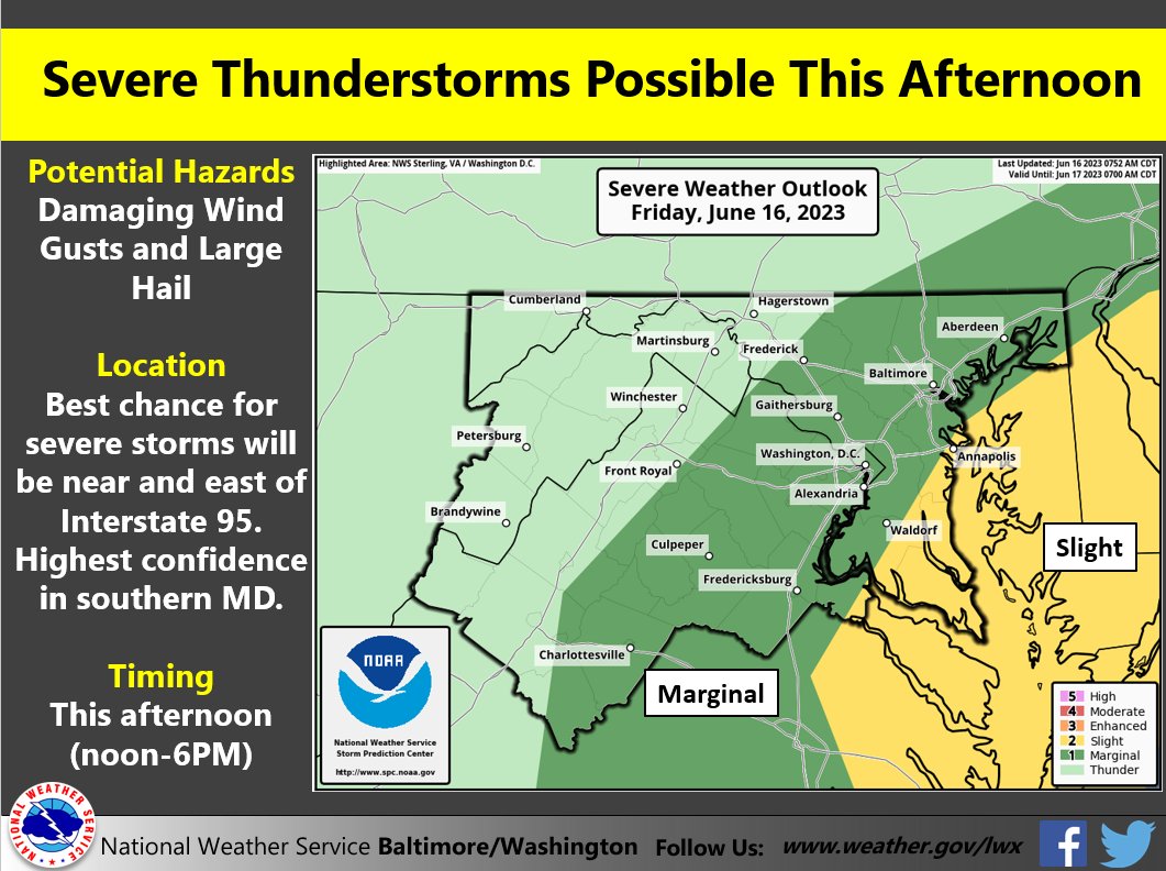
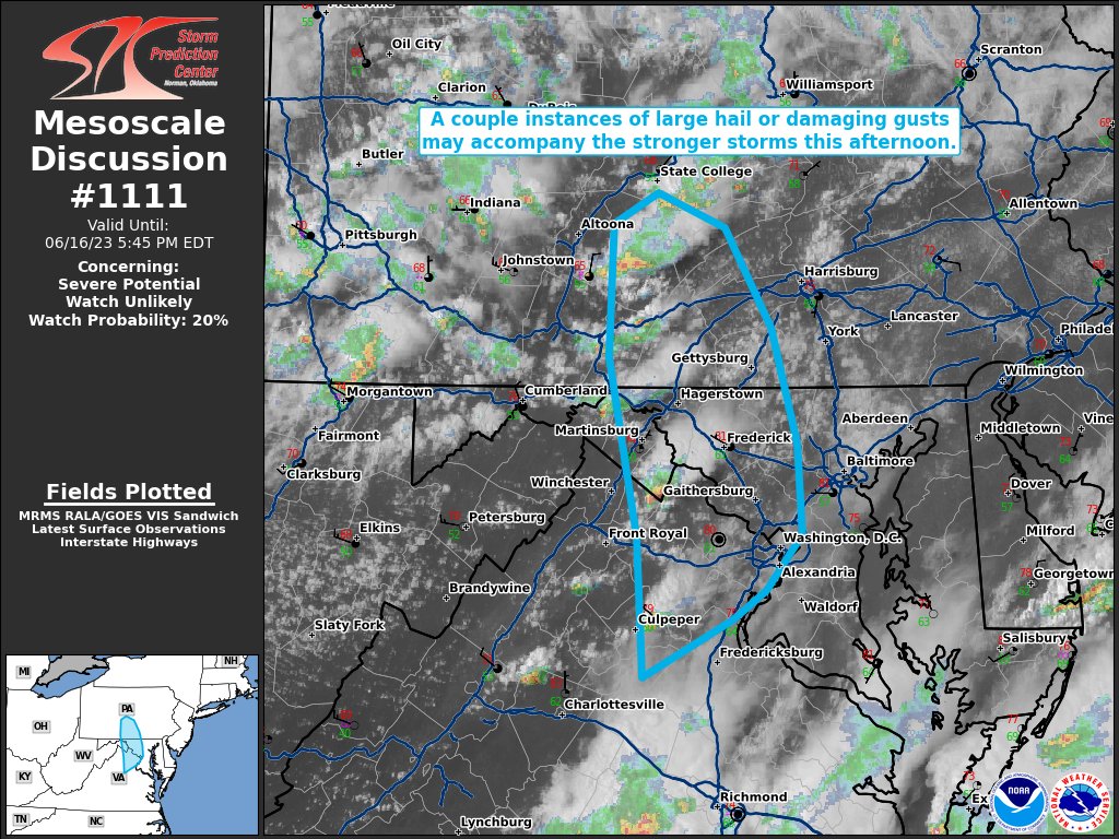
Severe Thunderstorms are possible today along and east of Interstate 95. Possible Hazards include damaging wind gusts and large hail. Mariners should be aware of the potential for rapidly changing conditions. Stay up to date at weather.gov/lwx

Severe Thunderstorms are possible today along and east of Interstate 95. Possible Hazards include damaging wind gusts and large hail.  Mariners should be aware of the potential for rapidly changing conditions. Stay up to date at weather.gov/lwx #MDwx #VAwx #DCwx #WVwx
account_circle
Peter Mullinax(@wxmvpete) 's Twitter Profile Photo

Taking a look west from the top of the Washington Monument. You can make out the Lincoln Memorial and Potomac River some. But Virginia is not visible. The other picture shows what it looked like 3 days ago.

Taking a look west from the top of the Washington Monument. You can make out the Lincoln Memorial and Potomac River some. But Virginia is not visible. The other picture shows what it looked like 3 days ago. #dcwx #vawx
account_circle
Maryland Weather(@stateMDWX) 's Twitter Profile Photo

Severe Thunderstorm Watch 318 continues for Chesapeake Bay from Drum Point MD to Smith Point VA, Tangier Sound, Tidal Potomac from Indian Head MD to Smith Point VA, until 9:00 PM EDT.

Severe Thunderstorm Watch 318 continues for Chesapeake Bay from Drum Point MD to Smith Point VA, Tangier Sound, Tidal Potomac from Indian Head MD to Smith Point VA, until 9:00 PM EDT.
#DCwx #MDwx
account_circle
Maryland Weather(@stateMDWX) 's Twitter Profile Photo

Special Marine Warning including Tidal Potomac from Key Bridge to Cobb Island MD, until 6:15 PM EDT.
[wind: >34 KTS, hail: 0.00 IN]

Special Marine Warning including Tidal Potomac from Key Bridge to Cobb Island MD, until 6:15 PM EDT.
[wind: >34 KTS, hail: 0.00 IN]
#DCwx #MDwx
account_circle
Greater Good Mining(@Gr8erGoodMining) 's Twitter Profile Photo

Check out my $KAS Kaspa Asic KS0 set up video!!!
youtu.be/SBMP3xNN4xY

You might have already seen that my KS0 arrived today!

I was so nervous when I ordered my KS0 and KS1 the minute the pre-order went live. I took a huge risk and went for it, and I'm happy to say my KS0…

account_circle