Ryan Voutilainen 🇨🇦🇫🇮 (@ryanvoutilainen) 's Twitter Profile
Ryan Voutilainen 🇨🇦🇫🇮

@ryanvoutilainen

BC based Weather/Storm Chaser & freelancer documenting notable weather & other events. Member of @EhTeamChasers. 🌪️=5 (he/him)

ID: 1209168683412516864

calendar_today23-12-2019 17:47:56

41,41K Tweet

5,5K Takipçi

3,3K Takip Edilen
Matthew Pfab (@the_weatherman2) 's Twitter Profile Photo

View of the rapidly growing #wildfire south of Port Alberni, BC…seen from Semiahmoo Spit in Blaine, WA, around 8:00 PM Monday. Seems to be some pyrocumulus fire behavior. #bcstorm #ShareYourWeather Ryan Voutilainen 🇨🇦🇫🇮 The Weather Network
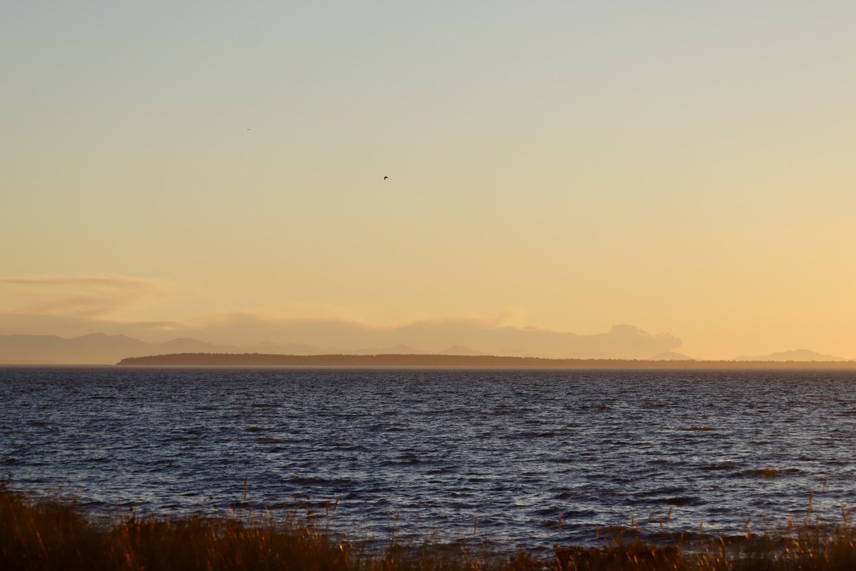
View of the rapidly growing #wildfire south of Port Alberni, BC…seen from Semiahmoo Spit in Blaine, WA, around 8:00 PM Monday. Seems to be some pyrocumulus fire behavior. #bcstorm #ShareYourWeather <a href="/RyanVoutilainen/">Ryan Voutilainen 🇨🇦🇫🇮</a> <a href="/weathernetwork/">The Weather Network</a>
Ryan Voutilainen 🇨🇦🇫🇮 (@ryanvoutilainen) 's Twitter Profile Photo

Shooting thru airplane windows does not make this easy, not to mention turbulence from thunderstorms, but #AuroraBorealis making an appearance over N Ontario & S Manitoba on my flight #AC313 from YUL to YVR - 11:41p CDT #ONstorm #MBstorm #NorthernLights #AuroraWatch Peter Vogel
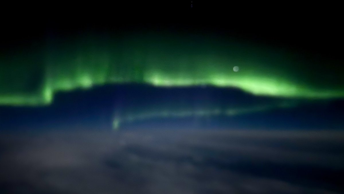
Shooting thru airplane windows does not make this easy, not to mention turbulence from thunderstorms, but #AuroraBorealis making an appearance over N Ontario &amp; S Manitoba on my flight #AC313 from YUL to YVR - 11:41p CDT

#ONstorm #MBstorm #NorthernLights #AuroraWatch <a href="/PeterVogel/">Peter Vogel</a>
Ryan Voutilainen 🇨🇦🇫🇮 (@ryanvoutilainen) 's Twitter Profile Photo

#AuroraBorealis from 11km/36kft on Air Canada flight #AC313 from YUL to YVR as seen a few hundred kms outside #Saskatoon #SK 11:23p CST / MDT — 11 Aug 2025 #ShareYourWeather #NorthernLights #AuroraWatch Kim MacDonald 🌻 Chris Murphy TWN Dr. Tamitha Skov Vincent Ledvina Peter Vogel Kyle Brittain
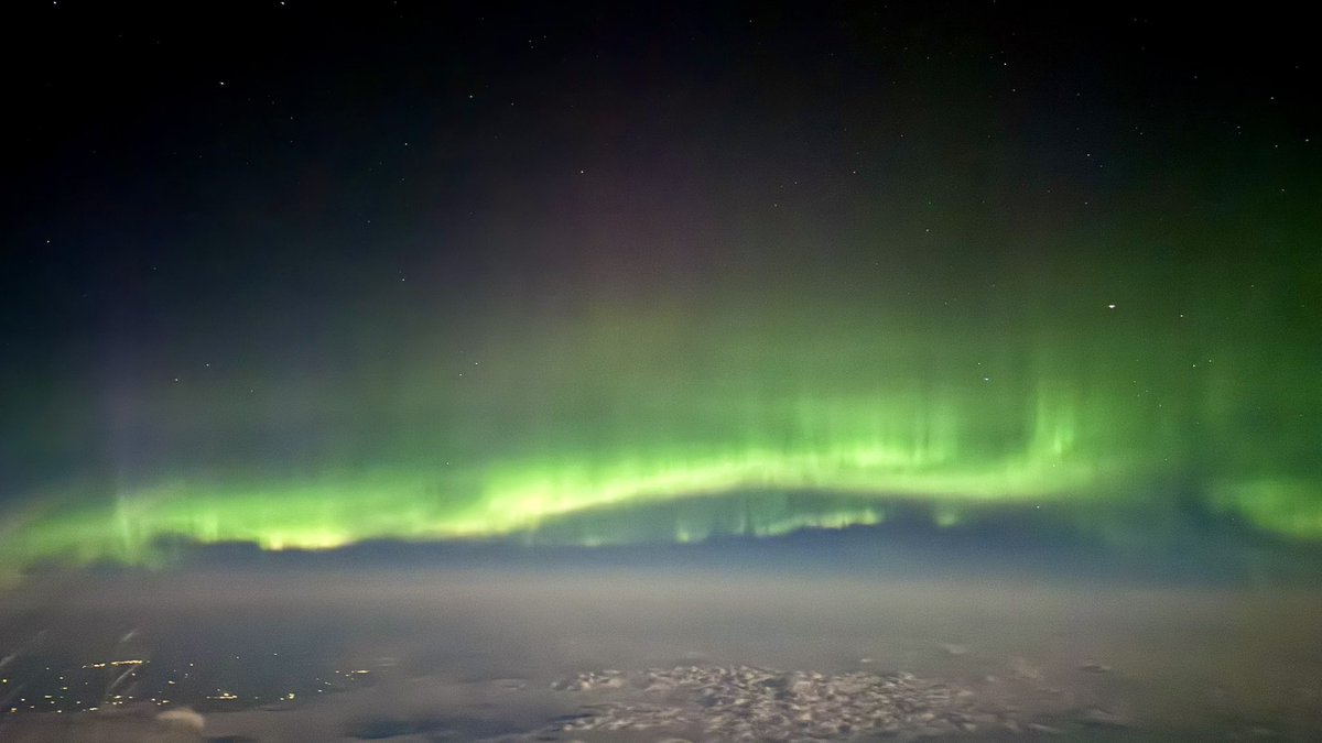
#AuroraBorealis from 11km/36kft on Air Canada flight #AC313 from YUL to YVR as seen a few hundred kms outside #Saskatoon #SK
11:23p CST / MDT — 11 Aug 2025

#ShareYourWeather #NorthernLights #AuroraWatch <a href="/KMacTWN/">Kim MacDonald 🌻</a> <a href="/MurphTWN/">Chris Murphy TWN</a> <a href="/TamithaSkov/">Dr. Tamitha Skov</a> <a href="/Vincent_Ledvina/">Vincent Ledvina</a> <a href="/PeterVogel/">Peter Vogel</a> <a href="/BadWeatherKyle/">Kyle Brittain</a>
Ryan Voutilainen 🇨🇦🇫🇮 (@ryanvoutilainen) 's Twitter Profile Photo

Video of the newly discovered Mount Underwood Wildfire to the south of Port Alberni BC | the #BCwildfire listed out of control and exhibiting fire growth. For updates follow BC Wildfire Service or wildfiresituation.nrs.gov.bc.ca/incidents?fire… #BCfire #BCheat #BCstorm #BCwx

Thierry Goose (@thierrygoosebc) 's Twitter Profile Photo

Confirmed! 🚨 With 18.8°C yesterday, Vancouver YVR had its 3rd highest August minimum temperature since records began in 1937, only 0.6°C below the monthly record. #BCstorm #BCwx

Confirmed! 🚨

With 18.8°C yesterday, Vancouver YVR had its 3rd highest August minimum temperature since records began in 1937, only 0.6°C below the monthly record. #BCstorm #BCwx
Thierry Goose (@thierrygoosebc) 's Twitter Profile Photo

‼️HISTORIC HEAT IN EASTERN CANADA‼️ 🌡️38.6°C Miramichi, NB, only 0.8°C from the NB all-time record! 🌡️38.1°C Maple Plains, PE = ALL-TIME RECORD for PE! 🌡️36.7°C Badger, NL = ALL-TIME RECORD for NEWFOUNDLAND. More data with help of Patrick Duplessis, Cape Breton Mesonet & Rodney Barney. #NBstorm
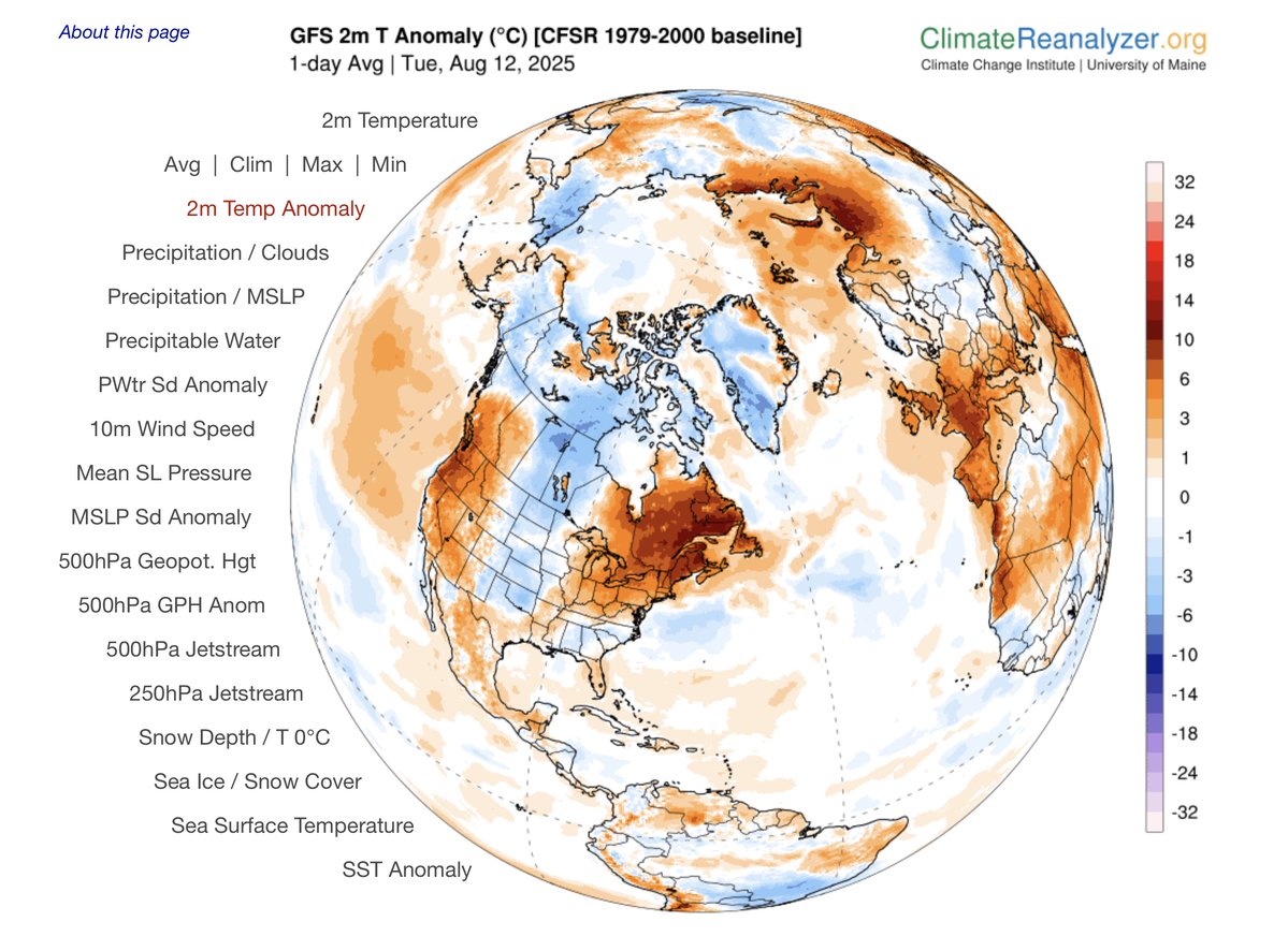
‼️HISTORIC HEAT IN EASTERN CANADA‼️

🌡️38.6°C Miramichi, NB, only 0.8°C from the NB all-time record!

🌡️38.1°C Maple Plains, PE = ALL-TIME RECORD for PE!

🌡️36.7°C Badger, NL = ALL-TIME RECORD for NEWFOUNDLAND.

More data with help of <a href="/Pat_wx/">Patrick Duplessis</a>, <a href="/CBmesonet/">Cape Breton Mesonet</a> &amp; <a href="/rcbstormpost/">Rodney Barney</a>. #NBstorm
Ryan Voutilainen 🇨🇦🇫🇮 (@ryanvoutilainen) 's Twitter Profile Photo

While onshore flow normally clears us out of smoke, in an unusual twist. It is resulting in smoke becoming perilously close to Vancouver as it blows in from the #MountUnderwood #BCwildfire in strong winds - 7:11p PT #SureYourWeather #BCStorm #BCSmoke #BCStormWatch #YVRwx #BCwx

Ryan Voutilainen 🇨🇦🇫🇮 (@ryanvoutilainen) 's Twitter Profile Photo

The entrance to False Creek & the False Creek ferry dock at West End Aquatic Centre as smoke from the Mount Underwood #BCwildfire streams overhead. #BCsmoke #BCwx #BCstorm #BCstormwatch #YVRwx

Ryan Voutilainen 🇨🇦🇫🇮 (@ryanvoutilainen) 's Twitter Profile Photo

Tornado Watch issued for parts of SE and E Central Alberta as a boundary pushes thru. I would expect the watch to be expanded east within the hour or two. Meanwhile, Tornado Warning the The Battlefords - Take cover now! CASSU - Super-Res Reflectivity 1 13:53 #ABStorm #SKstorm

Michael Snyder (@seattlewxguy) 's Twitter Profile Photo

Precipitable water over 200%, 22mb Gradient means blustery winds and desperately needed rainfall incoming! #bcstorm #wawx #orwx

Precipitable water over 200%, 22mb Gradient means blustery winds and desperately needed rainfall incoming! #bcstorm #wawx #orwx
Ryan Voutilainen 🇨🇦🇫🇮 (@ryanvoutilainen) 's Twitter Profile Photo

Another day, another pyrocumulus cloud associated w/ the #MountUnderwoodFire near Port Alberni… While smoke has been an occasional nuisance for some, it’s a reminder others are being displaced by a #BCwildfire — Significant rain expected soon, that should help! #BCstorm #BCwx

Ryan Voutilainen 🇨🇦🇫🇮 (@ryanvoutilainen) 's Twitter Profile Photo

#Tornado Warning In effect for R.M. of Chesterfield including Eatonia and Mantario, SK At 3:35 p CST, ECCC is tracking a severe thunderstorm that is possibly producing a tornado. Damaging winds, large hail & intense rainfall are also possible. Take cover immediately, #SKStorm

Jason Ross (@squamishweather) 's Twitter Profile Photo

An unusually strong system will reach the region late this evening through Saturday morning. This system is being fueled by a strong upper-level low/shortwave trough, as well as remnant moisture from ex-typhoons and tropical storms, which will produce rain at times heavy over the

An unusually strong system will reach the region late this evening through Saturday morning. This system is being fueled by a strong upper-level low/shortwave trough, as well as remnant moisture from ex-typhoons and tropical storms, which will produce rain at times heavy over the
Thierry Goose (@thierrygoosebc) 's Twitter Profile Photo

📉 Exceptionally low temperatures for mid-August in northern BC. 🌡️0.0°C Prince George ➡️ Earliest 0°C since 1968! [0.0°C on Aug. 8, 1968; also 0.4°C on Aug. 9, 2007] 🌡️1.5°C Mackenzie 🌡️2.2°C Dawson Creek 🌡️3.2°C Quesnel 🌡️3.9°C Chetwynd 🌡️4.0°C Fort Nelson #BCstorm #BCwx

📉 Exceptionally low temperatures for mid-August in northern BC.

🌡️0.0°C Prince George ➡️ Earliest 0°C since 1968! [0.0°C on Aug. 8, 1968; also 0.4°C on Aug. 9, 2007]

🌡️1.5°C Mackenzie
🌡️2.2°C Dawson Creek
🌡️3.2°C Quesnel
🌡️3.9°C Chetwynd
🌡️4.0°C Fort Nelson
#BCstorm #BCwx
Ryan Voutilainen 🇨🇦🇫🇮 (@ryanvoutilainen) 's Twitter Profile Photo

Weather Eye Candy! A classic November low w/ associated Atmospheric River.. In August! The dousing we need to help with forest fire suppression efforts on Vancouver Island (BC) and the Olympics Mountains (WA) GOES-W FD - True Color RGB Band 1/2/3 - 08:40 - #BCwx #BCstorm #WAwx

Weather Eye Candy! A classic November low w/ associated Atmospheric River.. In August! 

The dousing we need to help with forest fire suppression efforts on Vancouver Island (BC) and the Olympics Mountains (WA)

GOES-W FD - True Color RGB Band 1/2/3 - 08:40 - #BCwx #BCstorm #WAwx