Storm Chaser Luis Chacon (@roplaywx) 's Twitter Profile
Storm Chaser Luis Chacon

@roplaywx

Teen | Future Full Time Meteorologist | National Weather Tracker | Storm Chaser apart of the @FLStormChasers_

ID: 1435343116245032960

linkhttps://x.com/RSWCWX calendar_today07-09-2021 20:44:15

3,3K Tweet

194 Followers

324 Following
Reed Timmer, PhD (@reedtimmerusa) 's Twitter Profile Photo

I am devastated to share that the love of my life, Gizmo, has passed away at the age of 17. We shared so many memories and storm chasing adventures together especially over the last 15 years. Gizmo chased over 200 tornadoes, category 5 hurricanes, and loved me unconditionally

I am devastated to share that the love of my life, Gizmo, has passed away at the age of 17. We shared so many memories and storm chasing adventures together especially over the last 15 years. Gizmo chased over 200 tornadoes, category 5 hurricanes, and loved me unconditionally
National Hurricane Center (@nhc_atlantic) 's Twitter Profile Photo

8am EDT Aug 5 - In addition to Tropical Storm #Dexter, NHC is also monitoring two areas: (1) off the southeastern U.S. coast & (2) a tropical wave off Africa. Both have a medium chance (đźź )of tropical cyclone formation over the next 7 days. Latest at hurricanes.gov

8am EDT Aug 5 - In addition to Tropical Storm #Dexter,  NHC is also monitoring two areas: (1) off the southeastern U.S. coast & (2) a tropical wave off Africa. 

Both have a medium chance (đźź )of tropical cyclone formation over the next 7 days.

Latest at hurricanes.gov
Reed Timmer, PhD (@reedtimmerusa) 's Twitter Profile Photo

We just landed in South Dakota and are dedicating this storm chase and all future storm chases to the #1 storm chasing dog, Gizmo. Dominator Fore is targeting the Hoven, SD area

We just landed in South Dakota and are dedicating this storm chase and all future storm chases to the #1 storm chasing dog, Gizmo. Dominator Fore is targeting the Hoven, SD area
T.J. Springer (@tjspringerwx) 's Twitter Profile Photo

#TORNADO TOUCHDOWN: Here's the latest on the tornado that briefly touched down in Osceola County Monday evening. Because of the track, there was limited access to really survey, so the NWS Melbourne has deemed this an EF-U (unknown strength). #flwx #weather FOX 35 Orlando

#TORNADO TOUCHDOWN: Here's the latest on the tornado that briefly touched down in Osceola County Monday evening. Because of the track, there was limited access to really survey, so the <a href="/NWSMelbourne/">NWS Melbourne</a> has deemed this an EF-U (unknown strength). #flwx #weather <a href="/fox35orlando/">FOX 35 Orlando</a>
T.J. Springer (@tjspringerwx) 's Twitter Profile Photo

It's been another busy evening of strong to #severe #storms! Check out this photo from FOX 35 Orlando viewer Nate Swann. Looks to be a developing mesocyclone and potentially just before a funnel cloud formed. #flwx #weather #WeatherUpdate #weatherphotography #severeweather
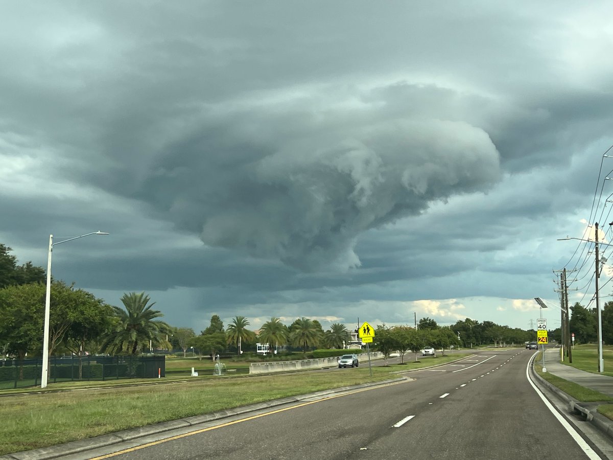

It's been another busy evening of strong to #severe #storms! Check out this photo from 
<a href="/fox35orlando/">FOX 35 Orlando</a> viewer Nate Swann. Looks to be a developing mesocyclone and potentially just before a funnel cloud formed. 
 #flwx #weather #WeatherUpdate #weatherphotography #severeweather
Jessica Dobson (@jessicadobsonwx) 's Twitter Profile Photo

Arguably one of best weather videos of the year so far! An unreal view of a crawler from Tuesday’s storms⚡️ 📍 - Winter Park, FL 🎥 - Zoe Belanger #FLwx

Weather Track US (@weathertrackus) 's Twitter Profile Photo

The SPC has upgraded tomorrow's risk to Enhanced across parts of North Dakota. A significant severe weather event is likely, mainly in the form of a destructive MCS. Very large hail & tornadoes will be possible as well.

The SPC has upgraded tomorrow's risk to Enhanced across parts of North Dakota.

A significant severe weather event is likely, mainly in the form of a destructive MCS. Very large hail &amp; tornadoes will be possible as well.
Florida Storm Chasers (@flstormchasers_) 's Twitter Profile Photo

UPDATE: Colorado State University has released their August 6th forecast for this Atlantic Hurricane Season and is once again predicting a 32% CHANCE that a Major #Hurricane could be in the red circled area this year! As always, we'll keep you updated! #wx #flwx

UPDATE: Colorado State University has released their August 6th forecast for this Atlantic Hurricane Season and is once again predicting a 32% CHANCE that a Major #Hurricane could be in the red circled area this year! As always, we'll keep you updated!

#wx #flwx
T.J. Springer (@tjspringerwx) 's Twitter Profile Photo

#INVEST96L has formed in the #Atlantic. We're watching this wave closely as it looks like it has some solid potential to organize. There's another coming off the coast of Africa that could do the same. There's a 60% chance of development over the next 7 days. #flwx #tropics

#INVEST96L has formed in the #Atlantic. We're watching this wave closely as it looks like it has some solid potential to organize. There's another coming off the coast of Africa that could do the same. There's a 60% chance of development over the next 7 days. #flwx #tropics
Hurricane Chaser Chase (@hurricane_chase) 's Twitter Profile Photo

12z EPS is out and confidence is increasing that another tropical wave may attempt to form over the next 10 days. Hoping it will recurve out to sea, but it's quite uncertain. Expecting NHC to mark it within the next 1-4 updates as it is approaching the 7-day range! #wx

Florida Storm Chasers (@flstormchasers_) 's Twitter Profile Photo

A Severe Thunderstorm Warning is in effect until 5:15 PM EDT for southern Duval County, northeastern Clay County, and west central St. Johns County in northeastern Florida, including areas near Green Cove Springs, Mandarin, Fruit Cove, Fleming Island, and Switzerland. This storm

A Severe Thunderstorm Warning is in effect until 5:15 PM EDT for southern Duval County, northeastern Clay County, and west central St. Johns County in northeastern Florida, including areas near Green Cove Springs, Mandarin, Fruit Cove, Fleming Island, and Switzerland. This storm
Matt Devitt (@mattdevittwx) 's Twitter Profile Photo

NEW: Home struck by lightning, setting it on fire in the Esplanade Lake Club community. This is off Alico Rd near Miromar Lakes in Southwest Florida. @WINKNews NWS Tampa Bay

NWS Tampa Bay (@nwstampabay) 's Twitter Profile Photo

The NOAA Weather Radio test will not be conducted this evening due to thunderstorms moving across the region. The weekly NWR test will resume next Wednesday, weather permitting. đź“» #FLwx