NY State Weather Risk Communication Center (@nyswrcc) 's Twitter Profile
NY State Weather Risk Communication Center

@nyswrcc

The State Weather Risk Communication Center at @UAlbany is a partnership with the New York State Division of Homeland Security and Emergency Services.

ID: 1638276314988793876

linkhttps://www.albany.edu/state-weather-risk-communication-center calendar_today21-03-2023 20:29:12

114 Tweet

908 Takipçi

84 Takip Edilen

NY State Weather Risk Communication Center (@nyswrcc) 's Twitter Profile Photo

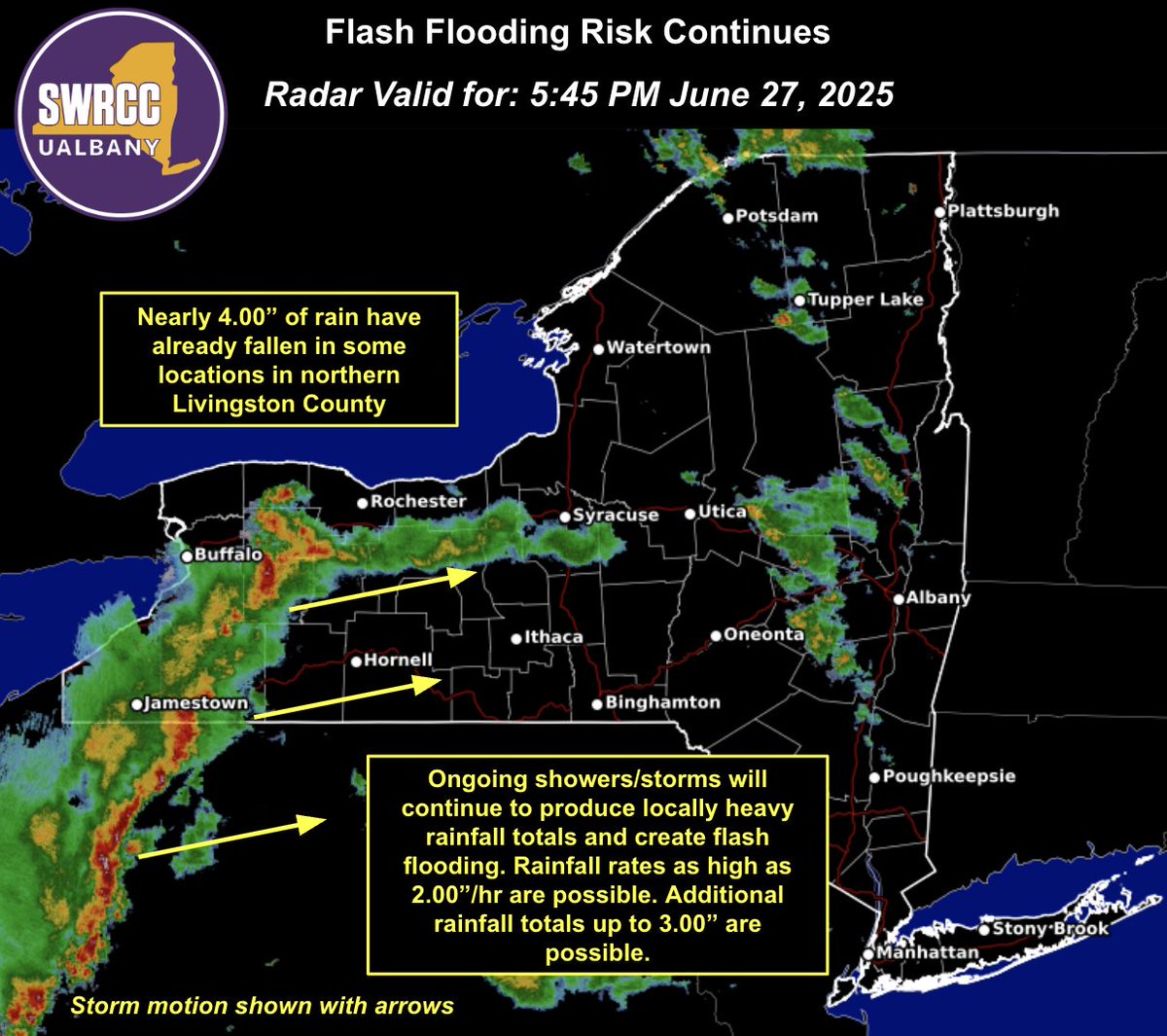
Nearly 4.00" of rain has already fallen in northern Livingston County since 2PM. More showers & storms will continue to create a flash flooding risk through this evening. Stay weather-aware & sign up for real-time alerts in your area by texting your county or borough to 333111.

Nearly 4.00" of rain has already fallen in northern Livingston County since 2PM. More showers & storms will continue to create a flash flooding risk through this evening.

Stay weather-aware & sign up for real-time alerts in your area by texting your county or borough to 333111.
NY State Weather Risk Communication Center (@nyswrcc) 's Twitter Profile Photo

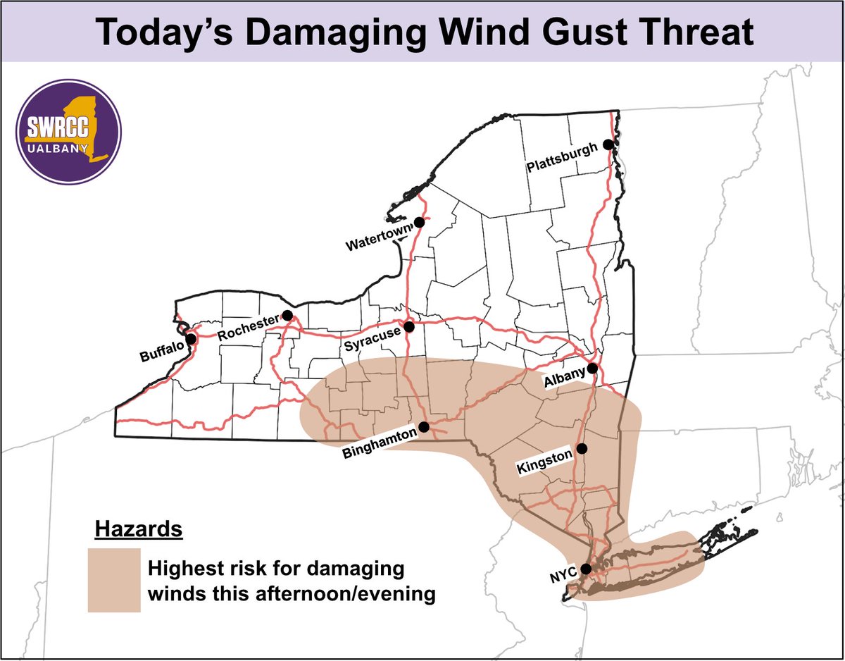
New York: Isolated-to-scattered damaging wind gusts are possible this afternoon and evening. The greatest risk is across the tan shaded area below.

New York: Isolated-to-scattered damaging wind gusts are possible this afternoon and evening. The greatest risk is across the tan shaded area below.
NY State Weather Risk Communication Center (@nyswrcc) 's Twitter Profile Photo

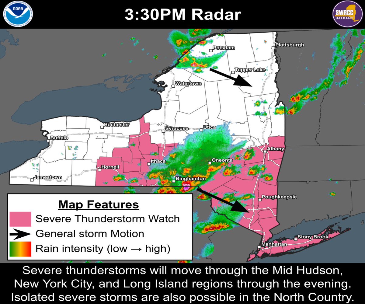
Thunderstorms with a history of damaging winds and large hail are entering the Mid-Hudson region, and will likely impact the evening commute. The severe risk will persist across the Mid-Hudson and Downstate through about 8-9 PM.

Thunderstorms with a history of damaging winds and large hail are entering the Mid-Hudson region, and will likely impact the evening commute. The severe risk will persist across the Mid-Hudson and Downstate through about 8-9 PM.
NY State Weather Risk Communication Center (@nyswrcc) 's Twitter Profile Photo

This morning our team hosted Governor Kathy Hochul and Commissioner Jackie Bray at our Center to discuss ways we can keep NYers safe during extreme weather. Planning for a Texas-sized flood was a top concern. Afterward, Director Nick Bassill spoke alongside Governor Hochul & Commissioner Bray.

This morning our team hosted <a href="/GovKathyHochul/">Governor Kathy Hochul</a> and <a href="/DHSESCommish/">Commissioner Jackie Bray</a> at our Center to discuss ways we can keep NYers safe during extreme weather. Planning for a Texas-sized flood was a top concern.

Afterward, Director Nick Bassill spoke alongside Governor Hochul &amp; Commissioner Bray.
NYS Div. of Homeland Security & Emergency Services (@nysdhses) 's Twitter Profile Photo

Thunderstorms are developing over central eastern parts of the state. These storms will strengthen & become more widespread as they approach the Mid-Hudson, NYC & LI regions. Some storms may become strong-to-severe with isolated-to-scattered damaging winds through about 8PM.

Thunderstorms are developing over central eastern parts of the state. These storms will strengthen &amp; become more widespread as they approach the Mid-Hudson, NYC &amp; LI regions.

Some storms may become strong-to-severe with isolated-to-scattered damaging winds through about 8PM.
NY State Weather Risk Communication Center (@nyswrcc) 's Twitter Profile Photo

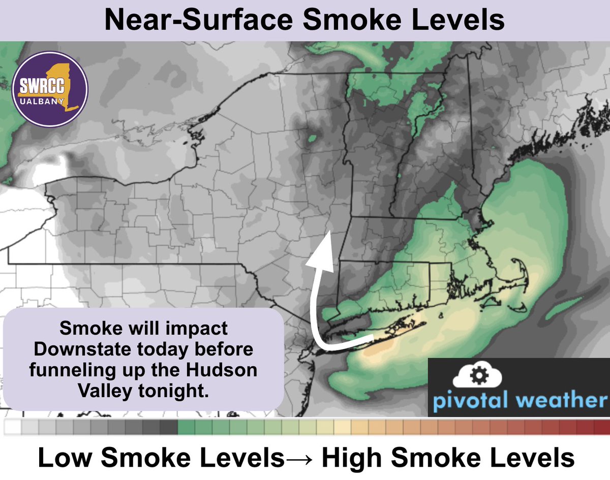
Air quality alerts have been issued for all of eastern NY today as wildfire smoke moves south to north now through tomorrow morning. Sensitive individuals should consider limiting outdoor physical activity.

Air quality alerts have been issued for all of eastern NY today as wildfire smoke moves south to north now through tomorrow morning. Sensitive individuals should consider limiting outdoor physical activity.
NY State Weather Risk Communication Center (@nyswrcc) 's Twitter Profile Photo

Moderate-to-heavy rainfall will continue to fall across the state through this evening. The greatest flash flood risk is likely across the Mid-Hudson, NYC and Long Island Regions. Rainfall will peak in intensity between 3PM - 9PM Thursday, which may impact the evening commute.

Moderate-to-heavy rainfall will continue to fall across the state through this evening. The greatest flash flood risk is likely across the Mid-Hudson, NYC and Long Island Regions. Rainfall will peak in intensity between 3PM - 9PM Thursday, which may impact the evening commute.
NY State Weather Risk Communication Center (@nyswrcc) 's Twitter Profile Photo

The NWS Weather Prediction Center has upgraded the Moderate Risk for flash flooding to include NYC, western Long Island and the Lower Hudson Valley. Moderate-to-heavy rainfall is expected this afternoon and evening, which will likely result in flooding.

The <a href="/NWSWPC/">NWS Weather Prediction Center</a> has upgraded the Moderate Risk for flash flooding to include NYC, western Long Island and the Lower Hudson Valley. Moderate-to-heavy rainfall is expected this afternoon and evening, which will likely result in flooding.
NY State Weather Risk Communication Center (@nyswrcc) 's Twitter Profile Photo

Unfortunately, wildfire smoke will make an appearance again, crashing our high-pressure party. Smoke is expected tonight through Tuesday, with Monday having the highest smoke concentrations. Smoke will be the worst north of I-90, though degraded air quality is possible statewide.

Unfortunately, wildfire smoke will make an appearance again, crashing our high-pressure party. Smoke is expected tonight through Tuesday, with Monday having the highest smoke concentrations. Smoke will be the worst north of I-90, though degraded air quality is possible statewide.
NY State Weather Risk Communication Center (@nyswrcc) 's Twitter Profile Photo

Today we're beginning our very first class in our "Introduction to Weather Interpretation" course. This inaugural course will be conducted across four weeks and includes 16 emergency managers from across New York. We plan on more to come!

Today we're beginning our very first class in our "Introduction to Weather Interpretation" course. This inaugural course will be conducted across four weeks and includes 16 emergency managers from across New York. We plan on more to come!
NY State Weather Risk Communication Center (@nyswrcc) 's Twitter Profile Photo

We had a great meeting this week with our state assemblymember NYS Assemblymember Gabriella A. Romero and UAlbany Gov Relations, where we were able to discuss the various weather hazards that impact New York, and how we work with the state!

NY State Weather Risk Communication Center (@nyswrcc) 's Twitter Profile Photo

It was graduation day for our inaugural "Introduction to Weather Interpretation" course! EMs from across the state learned about weather and (weather) communication, culminating in a final "briefing" today. We thank the EMs & great partners at NYS Div. of Homeland Security & Emergency Services, NWS Albany, & NYS Mesonet at UAlbany

It was graduation day for our inaugural "Introduction to Weather Interpretation" course! EMs from across the state learned about weather and (weather) communication, culminating in a final "briefing" today.
We thank the EMs &amp; great partners at <a href="/NYSDHSES/">NYS Div. of Homeland Security & Emergency Services</a>, <a href="/NWSAlbany/">NWS Albany</a>, &amp; <a href="/nysmesonet/">NYS Mesonet at UAlbany</a>
NY State Weather Risk Communication Center (@nyswrcc) 's Twitter Profile Photo

Being prepared for the weather is a major part of why we exist, which is why we work so closely with our partners at NYS Div. of Homeland Security & Emergency Services. Check out more about what Commissioner Jackie Bray has to say on this topic in the interview below⤵️

NY State Weather Risk Communication Center (@nyswrcc) 's Twitter Profile Photo

The Storm Prediction Center has highlighted an area of concern, indicated by the yellow polygon below. Severe thunderstorms with high rainfall rates and damaging winds are possible through the evening. Isolated tree damage and utility disruptions may occur.

The Storm Prediction Center has highlighted an area of concern, indicated by the yellow polygon below. Severe thunderstorms with high rainfall rates and damaging winds are possible through the evening. Isolated tree damage and utility disruptions may occur.
NY State Weather Risk Communication Center (@nyswrcc) 's Twitter Profile Photo

Heavy rain and severe thunderstorms are possible with the incoming weather system. Steep rainfall rates may cause localized urban flash flooding in the lower Hudson Valley and Downstate tomorrow afternoon/evening. Below are the latest outlooks from the WPC and SPC.

Heavy rain and severe thunderstorms are possible with the incoming weather system. Steep rainfall rates may cause localized urban flash flooding in the lower Hudson Valley and Downstate tomorrow afternoon/evening. Below are the latest outlooks from the WPC and SPC.
NY State Weather Risk Communication Center (@nyswrcc) 's Twitter Profile Photo

Despite last week's rain, much of NY is still 1-3" below normal precipitation over the past 30 days. With no rain expected over the next 7 days, drought conditions are expected to worsen. Models are hinting at rain chances picking up next week. We're keeping our fingers crossed!

Despite last week's rain, much of NY is still 1-3" below normal precipitation over the past 30 days. With no rain expected over the next 7 days, drought conditions are expected to worsen. Models are hinting at rain chances picking up next week. We're keeping our fingers crossed!