Mike Upjohn (@mikeupjohn) 's Twitter Profile
Mike Upjohn

@mikeupjohn

Confessions of a Storm Geek! Senior Software Developer for @CMAPSoftware with a passion for chasing storms! #code #storms #weather

ID: 4835491865

linkhttps://www.github.com/MikeUpjohn/ calendar_today22-01-2016 15:54:25

7,7K Tweet

251 Followers

932 Following

BBC Weather (@bbcweather) 's Twitter Profile Photo

Hong Kong has just experienced its wettest August day on record. Roughly the same amount of rain fell in 17 hours that London gets on average in six months. Flash floods and landslides were reported, and 12000 lightning strikes accompanied the rainstorm.

Hong Kong has just experienced its wettest August day on record.

Roughly the same amount of rain fell in 17 hours that London gets on average in six months.

Flash floods and landslides were reported, and 12000 lightning strikes accompanied the rainstorm.
Reed Timmer, PhD (@reedtimmerusa) 's Twitter Profile Photo

Check out these incredible photos of Gizmo in her element! She is meeting storm chasers, smelling scents of nature, and waiting for storms to fire. Look at her beautiful face

Check out these incredible photos of Gizmo in her element! She is meeting storm chasers, smelling scents of nature, and waiting for storms to fire. Look at her beautiful face
WINTER Bad Influencer (@wintereracer) 's Twitter Profile Photo

Reed Timmer, PhD I’m an Oklahoma artist born and raised. I painted this portrait of Gizmo for you Reed Timmer, PhD I just don’t know how to get it to you. Please let me know. Thank you for always helping keep us safe!

<a href="/ReedTimmerUSA/">Reed Timmer, PhD</a> I’m an Oklahoma artist born and raised. I painted this portrait of Gizmo for you <a href="/ReedTimmerUSA/">Reed Timmer, PhD</a> I just don’t know how to get it to you. Please let me know. Thank you for always helping keep us safe!
Reed Timmer, PhD (@reedtimmerusa) 's Twitter Profile Photo

The much-anticipated in-depth analysis of the EF4+ Greenfield, Iowa #tornado. Could the winds approach the speed of sound in these suction vortices? WATCH: youtu.be/PG8dYK2wx6I?si…

NWS Phoenix (@nwsphoenix) 's Twitter Profile Photo

Phoenix Sky Harbor hit 118°F at 3:37 PM this afternoon, which sets a new record hottest temperature for August. Phoenix records date back to 1895. Temperatures are still bouncing between 116-118°F at this time. #azwx

Phoenix Sky Harbor hit 118°F at 3:37 PM this afternoon, which sets a new record hottest temperature for August. Phoenix records date back to 1895. Temperatures are still bouncing between 116-118°F at this time. #azwx
Surrey Palms & Exotics (@surreypalmswx) 's Twitter Profile Photo

Beyond this working week, it may be time to start paying attention to next weekend. The Met Office model has 22°C hPa 850 reinforcing on Saturday 16th and then 23°C on Sunday 17th. With dried out soils this 'could' lead to the hottest temperatures of the year next weekend. 📈🌡️

Beyond this working week, it may be time to start paying attention to next weekend.

The Met Office model has 22°C hPa 850 reinforcing on Saturday 16th and then 23°C on Sunday 17th.

With dried out soils this 'could' lead to the hottest temperatures of the year next weekend. 📈🌡️
UK Weather Updates (@ukwx_) 's Twitter Profile Photo

The 06z GFS suggests 8 consecutive days of 30°C being reached somewhere in the UK. From today, up to 18th August. The run sits bang in the middle of the ensemble pack, so a highly plausible run. A prolonged very warm/hot period. Could reach the mid 30s tomorrow and Wednesday.

James Peacock (@peacockreports) 's Twitter Profile Photo

Last night delivered the strongest example I've seen in the UK of rain from high based clouds evaporating in drier air below. Radar can't account for that & estimates wide swathes of 5-10 mm, locally over 20 mm for the past 24 hours. Gauges report just 1-2 mm, locally 3-4.

Last night delivered the strongest example I've seen in the UK of rain from high based clouds evaporating in drier air below.

Radar can't account for that &amp; estimates wide swathes of 5-10 mm, locally over 20 mm for the past 24 hours.

Gauges report just 1-2 mm, locally 3-4.
Nick's Weather Eye (@nickjf75) 's Twitter Profile Photo

THUNDERSTORM WATCH - WEDS 13 AUG 2025 ⚡️ Issued 2025-08-13 06:56:46 Valid: 13/08/2025 0600 to 14/08/2025 0600 Forecast Details 👇 netweather.tv/weather-foreca…

THUNDERSTORM WATCH - WEDS 13 AUG 2025 ⚡️

Issued 2025-08-13 06:56:46
Valid: 13/08/2025 0600 to 14/08/2025 0600

Forecast Details 👇

netweather.tv/weather-foreca…
Carol Kirkwood (@carolkirkwood) 's Twitter Profile Photo

Today in the circled area is where we are expecting temperatures in excess of 30C. Parts of Lincolnshire, south and east Yorkshire and the east Midlands could reach 33C or possibly even 34C. BBC Breakfast xxx
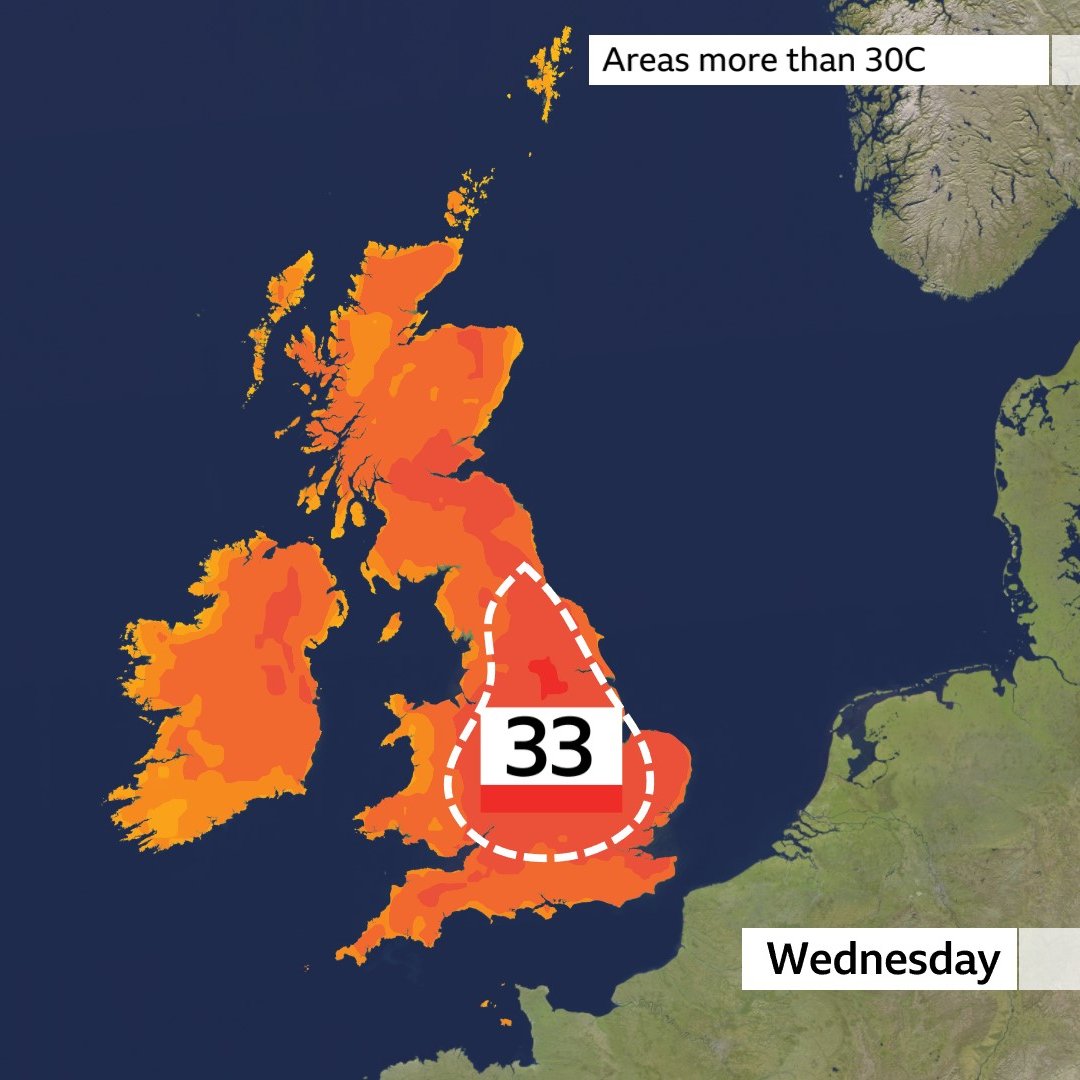
Today in the circled area is where we are expecting temperatures in excess of 30C.

Parts of Lincolnshire, south and east Yorkshire and the east Midlands could reach 33C or possibly even 34C.

<a href="/BBCBreakfast/">BBC Breakfast</a> xxx
Met Office (@metoffice) 's Twitter Profile Photo

After weeks of warmth, this week brings a change in the air. Expect largely settled conditions, but with a gradual dip in temperatures, especially across the north and east 🌡️ Cooler days 🌙 Chilly nights A gentle reminder that autumn is waiting in the wings 🍂

Explore Fall (@explorefall) 's Twitter Profile Photo

We're seeing the first signs of fall color today in remote Siberia. This is the first fall color anywhere on earth in Fall 2025.