Lauren Pounds (@laurenepounds) 's Twitter Profile
Lauren Pounds

@laurenepounds

Meteorologist. PhD Candidate @ousom. MSU ‘19 alum #HailState. Louisiana native. I only ever tweet about weather and sports.

ID: 536640556

calendar_today25-03-2012 20:58:41

3,3K Tweet

1,1K Takipçi

717 Takip Edilen

Tyler S (@tylerjstanfield) 's Twitter Profile Photo

It really cannot be overstated how anomalous this is. Hurricane #Beryl is on the verge of becoming the first ever Category 4 in the Atlantic in June after breaking multiple records for further east hurricane and major hurricane. This is an incredibly rare event.

University of Oklahoma (@uofoklahoma) 's Twitter Profile Photo

𝐓𝐡𝐞 𝐬𝐩𝐨𝐭𝐥𝐢𝐠𝐡𝐭 𝐣𝐮𝐬𝐭 𝐠𝐨𝐭 𝐛𝐢𝐠𝐠𝐞𝐫. Hello, Southeastern Conference. We're Oklahoma. ou.edu | #OUxSEC

Philip Klotzbach (@philklotzbach) 's Twitter Profile Photo

#Hurricane #Beryl has intensified to a Category 5 hurricane with max winds of 160 mph - the earliest calendar year Atlantic Category 5 hurricane on record. The prior record was Hurricane Emily on July 17, 2005 at 0UTC.

Jeff Frame (@vortexjeff) 's Twitter Profile Photo

Lauren Pounds contrasting tornadic and nontornadic environments in the Southeast. Not surprisingly, the tornadic environments exhibit stronger shear and storm-relative winds. #31SLS

Lauren Pounds contrasting tornadic and nontornadic environments in the Southeast. Not surprisingly, the tornadic environments exhibit stronger shear and storm-relative winds. #31SLS
Lauren Pounds (@laurenepounds) 's Twitter Profile Photo

Enjoyed sharing some of the (not surprising) preliminary results from the start of my PhD work this morning! Come see our poster at 1:15pm for the other part of this work! #31SLS

Max Ungar (@mesomaxwx) 's Twitter Profile Photo

NWS Indianapolis Sean Ash 10 AM (Monday) - Average of 4.5” off the snowboard since late Sunday evening, including a max of nearly 6” (pictured). Clearly had some drifting too, as evidenced in the photo. 2 SW Zionsville Storm Total: 11.1” Snow Depth: 9” NWS Indianapolis Sean Ash

<a href="/NWSIndianapolis/">NWS Indianapolis</a> <a href="/SeanAshWX/">Sean Ash</a> 10 AM (Monday) - Average of 4.5” off the snowboard since late Sunday evening, including a max of nearly 6” (pictured). Clearly had some drifting too, as evidenced in the photo. 

2 SW Zionsville 
Storm Total: 11.1”
Snow Depth: 9”

<a href="/NWSIndianapolis/">NWS Indianapolis</a> <a href="/SeanAshWX/">Sean Ash</a>
Payton Malone WWL-TV (@paytonmalonewx) 's Twitter Profile Photo

I’m still in disbelief this happened. Here it is. Timelapse of historic New Orleans snow storm. Snow got up to 12 inches on my snowboard in the French Quarter.

Eric Webb (@webberweather) 's Twitter Profile Photo

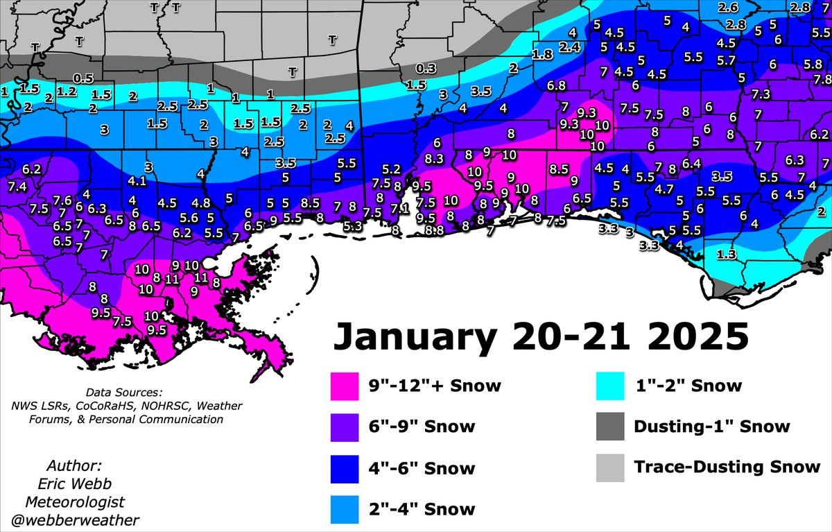
Here's my special hand-drawn snow accumulation map for the historic snowstorm that impacted the Gulf Coast earlier this week. This storm smashed a ton of records on the Gulf Coast & certainly will be remembered for many decades to come. The heaviest snow in excess of 9-10"

Here's my special hand-drawn snow accumulation map for the historic snowstorm that impacted the Gulf Coast earlier this week.

This storm smashed a ton of records on the Gulf Coast &amp; certainly will be remembered for many decades to come. 

The heaviest snow in excess of 9-10"
Dr. Levi Cowan (@tropicaltidbits) 's Twitter Profile Photo

I never publicly comment on political matters because they are usually irrelevant to my work of providing hurricane data and forecasts to people in my personal capacity. Today though, it is highly relevant, and as a member of the meteorological community, I am angry. Planned or

I never publicly comment on political matters because they are usually irrelevant to my work of providing hurricane data and forecasts to people in my personal capacity. Today though, it is highly relevant, and as a member of the meteorological community, I am angry.

Planned or