Kody Wilson (@kodythewxguy) 's Twitter Profile
Kody Wilson

@kodythewxguy

⛈Freelance Meteorologist 🌪Tornado Geek 🧑🏼‍💻Business Owner 📸 Weather Photographer 🙌🏼 Dream Chaser 📍Greeley, Colorado

ID: 1522027517825011712

linkhttp://kodythewxguy.com calendar_today05-05-2022 01:37:01

6,6K Tweet

16,16K Takipçi

86 Takip Edilen

Kody Wilson (@kodythewxguy) 's Twitter Profile Photo

A few showers and thunderstorms today, mainly along and west of I-25 between Denver and Trinidad. The best shot for activity will be over the elevated terrain, the Palmer Divide, foothills, Rampart Range, Sangre de Cristos, Wet Mountains, and down onto the Raton Mesa. ⛈️

A few showers and thunderstorms today, mainly along and west of I-25 between Denver and Trinidad. The best shot for activity will be over the elevated terrain, the Palmer Divide, foothills, Rampart Range, Sangre de Cristos, Wet Mountains, and down onto the Raton Mesa.

⛈️
Kody Wilson (@kodythewxguy) 's Twitter Profile Photo

🚨 Flash Flood Warning 🚨 For Monument, Woodmoor, and Palmer Lake ⛈️ Thunderstorms have stalled over the area and continue to dump heavy rain. 🌊 Flash flooding and dangerous travel conditions are being reported, including water ponding on I-25. ⚠️ Do not attempt to drive

🚨 Flash Flood Warning 🚨

For Monument, Woodmoor, and Palmer Lake

⛈️ Thunderstorms have stalled over the area and continue to dump heavy rain.

🌊 Flash flooding and dangerous travel conditions are being reported, including water ponding on I-25.

⚠️ Do not attempt to drive
Kody Wilson (@kodythewxguy) 's Twitter Profile Photo

The Derby Fire burning north of Dotsero in far NW Eagle County is very active tonight. Sitting at 245 acres. As I’ve mentioned before, cooler temperatures and chances for rain are coming Friday, this weekend, and into next week. Just need to get through the next couple of days.

The Derby Fire burning north of Dotsero in far NW Eagle County is very active tonight. Sitting at 245 acres. As I’ve mentioned before, cooler temperatures and chances for rain are coming Friday, this weekend, and into next week. Just need to get through the next couple of days.
Kody Wilson (@kodythewxguy) 's Twitter Profile Photo

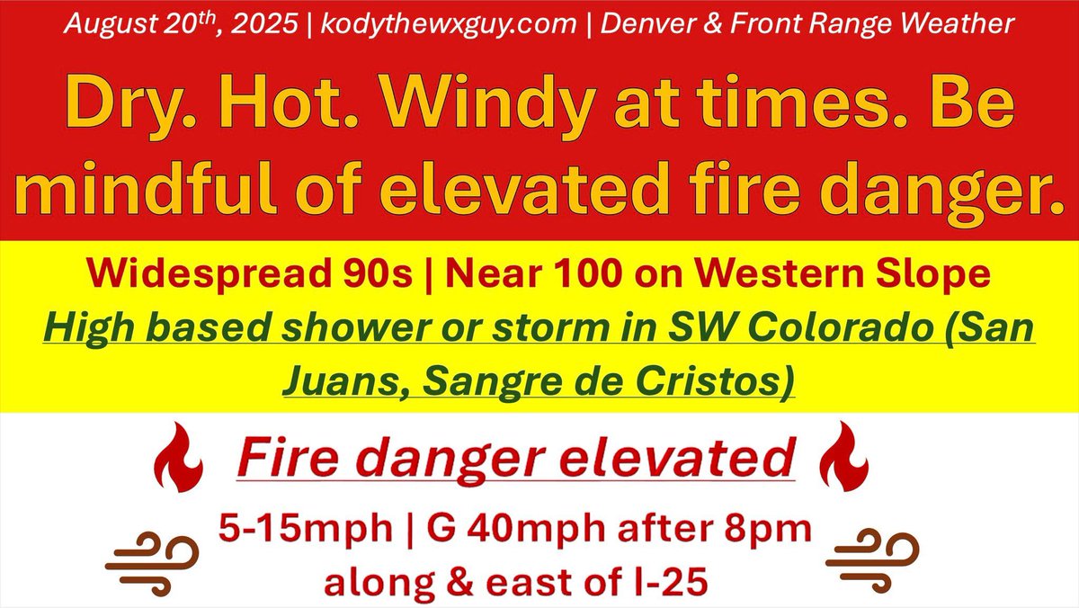
Good mernin and happy Wednesday, you little fried thunder biscuits 🌩️🍪 Today: Overwhelming majority of you will be hot and dry. Best shot for a high-based shower or storm will be in the San Juans and Sangre de Cristos. If one sneaks under the Palmer Divide, I won’t be shocked.

Good mernin and happy Wednesday, you  little fried thunder biscuits 🌩️🍪

Today: Overwhelming majority of you will be hot and dry. Best shot for a high-based shower or storm will be in the San Juans and Sangre de Cristos. If one sneaks under the Palmer Divide, I won’t be shocked.
Kody Wilson (@kodythewxguy) 's Twitter Profile Photo

🌞 Good mernin and happy Thursday, my precious little chicken nuggets. Let’s break it down: 🔥 Part 1 – Heat & fire danger Today = hot & gross. #LeGagMe East of the Divide: widespread 90s. Western Slope: low 100s + critical fire conditions. Ugh. After 1–2 PM: a few high-based

🌞 Good mernin and happy Thursday, my precious little chicken nuggets. Let’s break it down:

🔥 Part 1 – Heat & fire danger

Today = hot & gross. #LeGagMe 
East of the Divide: widespread 90s.
Western Slope: low 100s + critical fire conditions. Ugh. 
After 1–2 PM: a few high-based
Kody Wilson (@kodythewxguy) 's Twitter Profile Photo

⚡ Pattern change coming ⚡ A cold front tomorrow is the kick-off to a big shift in our weather going thru next week, and with monsoon moisture sneaking in from the southwest, we’re looking at multiple rounds of storms on Friday: 🌄 Morning (Fri): First round possible across

⚡ Pattern change coming ⚡

A cold front tomorrow is the kick-off to a big shift in our weather going thru next week, and with monsoon moisture sneaking in from the southwest, we’re looking at multiple rounds of storms on Friday:

🌄 Morning (Fri): First round possible across
Kody Wilson (@kodythewxguy) 's Twitter Profile Photo

Lift ahead of tomorrow’s cold front is sparking storms in Larimer County. North Fort Collins looking west 📸 Laura Hansen Toffoli

Lift ahead of tomorrow’s cold front is sparking storms in Larimer County. 

North Fort Collins looking west

📸 Laura Hansen Toffoli
Kody Wilson (@kodythewxguy) 's Twitter Profile Photo

Good mernin and happy Friday, my early risers, night owls, insomniacs, and neurospicy besties! The mucho-hyped, highly-advertised weather pattern change kicks off today. It's Gary Busey complicated. There’s a lot to unpack over the next week, so instead of dropping novels

Good mernin and happy Friday, my early risers, night owls, insomniacs, and neurospicy besties!

The mucho-hyped, highly-advertised weather pattern change kicks off today. It's Gary Busey complicated. 

There’s a lot to unpack over the next week, so instead of dropping novels
Kody Wilson (@kodythewxguy) 's Twitter Profile Photo

⚠️ Severe Thunderstorm Warning until 3:45 PM MDT 📍 Areas: Northeastern Fremont Co. Southern Teller Co. West-central El Paso Co. ⛈️ At 3:10 PM: storm over Victor (19 miles SW of Colorado Springs), moving east at 30 mph. Hazards: 🌨️ Quarter-size hail 🚗 Vehicle damage

⚠️ Severe Thunderstorm Warning until 3:45 PM MDT

📍 Areas:

Northeastern Fremont Co.
Southern Teller Co.
West-central El Paso Co.

⛈️ At 3:10 PM: storm over Victor (19 miles SW of Colorado Springs), moving east at 30 mph.

Hazards:

🌨️ Quarter-size hail
🚗 Vehicle damage
Kody Wilson (@kodythewxguy) 's Twitter Profile Photo

🌧️ Good mernin and happy Saturday, you precious little pickles. To the “where’s the rain, I haven’t seen any” crowd: calm your tits. We’ll be doing this dance all week, so settle in. This morning: mostly cloudy, a little drizzle, some light rain, and a few claps of thunder.

🌧️ Good mernin and happy Saturday, you precious little pickles. 

To the “where’s the rain, I haven’t seen any” crowd: calm your tits. We’ll be doing this dance all week, so settle in.

This morning: mostly cloudy, a little drizzle, some light rain, and a few claps of thunder.
Kody Wilson (@kodythewxguy) 's Twitter Profile Photo

Each day this week is gonna throw its own brand of forecast chaos at us, it’s a little Gary Busey complicated and a little Marilyn Manson complicated. For today, the main window is between about 2 and 9 PM. Inside my long skinny red square thingy (you know the one), I’ve

Each day this week is gonna throw its own brand of forecast chaos at us, it’s a little Gary Busey complicated and a little Marilyn Manson complicated. For today, the main window is between about 2 and 9 PM.

Inside my long skinny red square thingy (you know the one), I’ve
Kody Wilson (@kodythewxguy) 's Twitter Profile Photo

2:50 PM update Scattered thunderstorms are firing along and east of the Continental Divide. ⚡ Storms are active in the San Luis Valley, the San Juans, and the Sangre de Cristos with plenty of lightning. One storm I’m watching closely is sliding into Boulder County near

Kody Wilson (@kodythewxguy) 's Twitter Profile Photo

⛈️ Severe Thunderstorm Warning ⛈️ Until 4:15 PM MDT 📍 Areas Included: Eastern Gilpin County (Central CO) Northwestern Jefferson County (Central CO) Southwest & Southeast Boulder County (Northeastern CO) ⚡ At 3:49 PM MDT: A severe thunderstorm was located over Pinecliffe

⛈️ Severe Thunderstorm Warning ⛈️

Until 4:15 PM MDT

📍 Areas Included:

Eastern Gilpin County (Central CO)
Northwestern Jefferson County (Central CO)
Southwest & Southeast Boulder County (Northeastern CO)

⚡ At 3:49 PM MDT: A severe thunderstorm was located over Pinecliffe
Kody Wilson (@kodythewxguy) 's Twitter Profile Photo

⛈️ Severe storm update ⛈️ A severe storm is moving into northern Jefferson County and tracking southeast at about 25 mph. ⚠️ Hazards: Hail up to 1.5 inches in diameter (ping-pong ball size) Potential vehicle & roof damage 📍 Communities in the path: Golden • Genesee •

⛈️ Severe storm update ⛈️

A severe storm is moving into northern Jefferson County and tracking southeast at about 25 mph.

⚠️ Hazards:

Hail up to 1.5 inches in diameter (ping-pong ball size)

Potential vehicle & roof damage

📍 Communities in the path:

Golden • Genesee •