USGS (@usgs) 's Twitter Profile
USGS

@usgs

Science is only a tweet away. Tweets do not = endorsement: on.doi.gov/pgwu0Y

ID: 14505838

linkhttp://usgs.gov calendar_today24-04-2008 03:10:57

27,27K Tweet

780,780K Followers

83 Following

USGS (@usgs) 's Twitter Profile Photo

It’s #WildfirePreparednessMonth!🔥 There are many ways wildfires may change a landscape. Four examples we study include #flooding, #invasives, #landslides, & #pollution. Learn more 👉 ow.ly/ZS9U50VV8JM

USGS (@usgs) 's Twitter Profile Photo

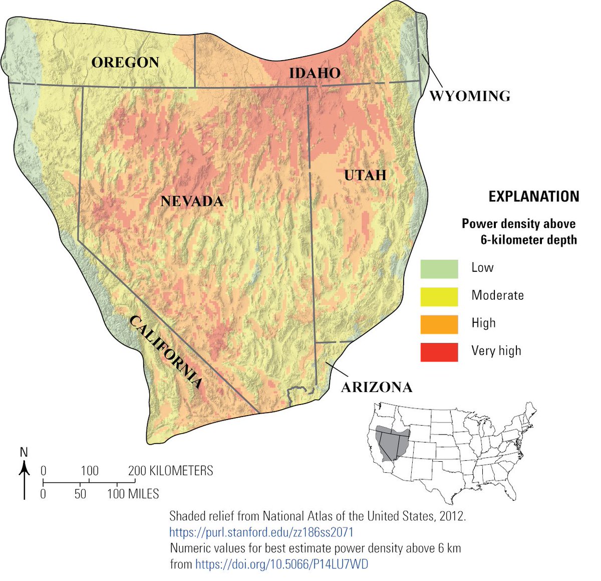
A new USGS assessment of enhanced geothermal systems shows the Great Basin could supply 10% of U.S. electricity demand. USGS science is #UnleashingAmericanEnergy! Check out the fact sheet here: ow.ly/7m0b50VXQsW

A new USGS assessment of enhanced geothermal systems shows the Great Basin could supply 10% of U.S. electricity demand. USGS science is #UnleashingAmericanEnergy!

Check out the fact sheet here: ow.ly/7m0b50VXQsW
USGS (@usgs) 's Twitter Profile Photo

Your weekend adventures powered by USGS! We track dangerous river conditions for kayakers, invisible toxins in swimming spots, and critical conditions for fish populations —hidden science keeping your outdoor thrills both fun AND safe! #waterscience

Your weekend adventures powered by USGS! We track dangerous river conditions for kayakers, invisible toxins in swimming spots, and critical conditions for fish populations —hidden science keeping your outdoor thrills both fun AND safe!

#waterscience
USGS (@usgs) 's Twitter Profile Photo

The New River Gorge is the deepest and longest gorge in the Appalachians and represents a significant part of our Nation’s mining history. Join us on a monthly journey discovering the geology beneath your feet at sites like this all over the Nation! 👉ow.ly/vRAG50W0Ygb

The New River Gorge is the deepest and longest gorge in the Appalachians and represents a significant part of our Nation’s mining history. 

Join us on a monthly journey discovering the geology beneath your feet at sites like this all over the Nation!  

👉ow.ly/vRAG50W0Ygb
USGS (@usgs) 's Twitter Profile Photo

🌲🔥 New insights into wildfire behavior across #Alaska! New USGS paper reveals fire dynamics to help to inform Alaska management strategies. Understanding these patterns is crucial for protecting ecosystems and communities. 👉ow.ly/Iltk50W17cn #WildfireAwarenessMonth

🌲🔥 New insights into wildfire behavior across #Alaska! 

New USGS paper reveals fire dynamics to help to inform Alaska management strategies. Understanding these patterns is crucial for protecting ecosystems and communities. 

👉ow.ly/Iltk50W17cn

#WildfireAwarenessMonth
USGS (@usgs) 's Twitter Profile Photo

🌎🛰️After 25 years of Earth observation, the USGS bids farewell to #Landsat7 June 4. The legacy continues with Landsat 8 and 9, capturing planetary imagery to support farmers, city planners, and disaster recovery. 👉ow.ly/ZTf150W4mp3 #EarthObservation #NASA

🌎🛰️After 25 years of Earth observation, the USGS bids farewell to #Landsat7 June 4. The legacy continues with Landsat 8 and 9, capturing planetary imagery to support farmers, city planners, and disaster recovery. 

👉ow.ly/ZTf150W4mp3

#EarthObservation #NASA
USGS MD-DE-DC (@usgs_md_de_dc) 's Twitter Profile Photo

USGS was in Western Maryland to assess #flooding at over two dozen locations, including #Westernport and Georges Creek. Quantifying floods is vital for planning #infrastructure that can withstand such extremes in the future.

USGS (@usgs) 's Twitter Profile Photo

Across the US Department of the Interior, scientists are using satellites, drones, & other tech to monitor the planet and tackle big questions about land use, natural hazards, & more. The 2024 DOI Remote Sensing Activities Report highlights many of these innovative efforts: ow.ly/cql750W5cbL

USGS (@usgs) 's Twitter Profile Photo

🌊 Happy #WorldOceanDay! USGS science doesn’t stop at the shoreline. From coastal hazards to deep-sea mysteries, our work helps reveal the interconnected systems shaping Earth’s oceans. Dive into our ocean science: ow.ly/AgAZ50ScmON

USGS (@usgs) 's Twitter Profile Photo

In September 2024, #HurricaneHelene made landfall, unleashing widespread flooding & extensive landsliding across southern Appalachia. As #HurricaneSeason ramps up, we look back at how that storm reframed the way people think about landslides. 👉ow.ly/ZYlX50W6v8m

In September 2024, #HurricaneHelene made landfall, unleashing widespread flooding & extensive landsliding across southern Appalachia.

As #HurricaneSeason ramps up, we look back at how that storm reframed the way people think about landslides. 👉ow.ly/ZYlX50W6v8m
USGS (@usgs) 's Twitter Profile Photo

Mapping, mine wastes, and more! The most recent Critical Minerals Annual Review, published in the journal Mining Engineering, highlights USGS accomplishments in critical minerals science from 2024. Check it out 👉ow.ly/cv9950W7iMv

USGS (@usgs) 's Twitter Profile Photo

USGS is measuring flooding across Texas & Oklahoma after 3 days of heavy rain. 21 streamgages showing flood conditions along I-35 corridor. More rain expected over the weekend. Stay safe & check conditions👉ow.ly/6Ft950W9gzb

USGS is measuring flooding across Texas & Oklahoma after 3 days of heavy rain. 21 streamgages showing flood conditions along I-35 corridor. More rain expected over the weekend. 

Stay safe & check conditions👉ow.ly/6Ft950W9gzb