Mickey
@mike65395
Geospatial Developer/Remote sensing/Land Survey/Cartographer
ID: 1661632031908831237
25-05-2023 07:15:47
104 Tweet
335 Followers
2,2K Following
 's Twitter Profile Photo")
 's Twitter Profile Photo")
 's Twitter Profile Photo")
 on Twitter photo Let’s see those desk setups.")
 's Twitter Profile Photo")
 on Twitter photo Do you want to learn how to create, edit, and analyze maps in Excel?
🌟Start this learning plan: ow.ly/n76V50WncoH")
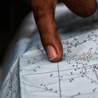
 on Twitter photo New week. New layers of perspective.
In GIS, it's tempting to chase the latest software, APIs or satellite data sources.
But here's the truth: Tools don’t solve problems, people do.
And the best people? They lead with context.
Before opening that GIS software or coding")
 's Twitter Profile Photo")
 's Twitter Profile Photo")
 's Twitter Profile Photo")
 's Twitter Profile Photo")
Learn how to create a polygon from Excel points. This tutorial is helpful, especially when dealing with Units and Parcel shapefiles to submit to #Ardhisasa platform. Nicholas Mutethia Karuma HOSEA™𓃵 🇰🇪 surveyor Fortune 💃🏼🇺🇬 Gitobu_001 LEVIS®™ 🇰🇪 Kocmohabt youtu.be/vuRYYPaQOFM?si…
 's Twitter Profile Photo")
 's Twitter Profile Photo")
 on Twitter photo I'm excited to reveal my brand-new digital book: Mapping the World with R: Your Journey from Beginner to Data Cartographer.
After years of coding, teaching, and sharing insights on my YouTube channel, I've compiled a comprehensive guide that demystifies spatial data")
 on Twitter photo 🌎GIS is more than just 3 letters! Learn fundamental concepts and basic components in this free course: ow.ly/Flv050WqGuO
#GIS")
 's Twitter Profile Photo")
 's Twitter Profile Photo")
 on Twitter photo 🐍Python is for everyone—especially when you take this web course!
👉 ow.ly/KCV650WqNfZ
Save time by learning how to automate ArcGIS workflows 🌎.")
 's Twitter Profile Photo")
 on Twitter photo 8 Easy and Cool Casual Outfits For Everyday Looks:
1.")
 's Twitter Profile Photo")
 on Twitter photo Meru County, Mbeu Ward. Community Borehole supply and distribution network mapping to support Gravity Analysis & Hydraulic Profiling for a gravity-fed system. The Infrawizard C3D plugin helped in the geometric modeling and reticulation of pipe networks. Piping an entire village!")
 's Twitter Profile Photo")