Journal of Remote Sensing (@journalofrs) 's Twitter Profile
Journal of Remote Sensing

@journalofrs

Science (AAAS) partner journal for leading-edge research in remote sensing. We publish original research and review articles, editorials, and perspectives.

ID: 1478253420817571847

linkhttps://spj.sciencemag.org/journals/remotesensing/ calendar_today04-01-2022 06:35:32

199 Tweet

429 Followers

562 Following

Journal of Remote Sensing (@journalofrs) 's Twitter Profile Photo

Unsupervised Cross-Regional and Cross-Year Adaptation by Climate Indicator Discrepancy for Crop Classification 1⃣A novel index was designed to quantify regional climate conditions, establishing a link between climate difference and spectral shift. 2⃣A method was proposed to

Unsupervised Cross-Regional and Cross-Year Adaptation by Climate Indicator Discrepancy for Crop Classification
1⃣A novel index was designed to quantify regional climate conditions, establishing a link between climate difference and spectral shift.
2⃣A method was proposed to
Journal of Remote Sensing (@journalofrs) 's Twitter Profile Photo

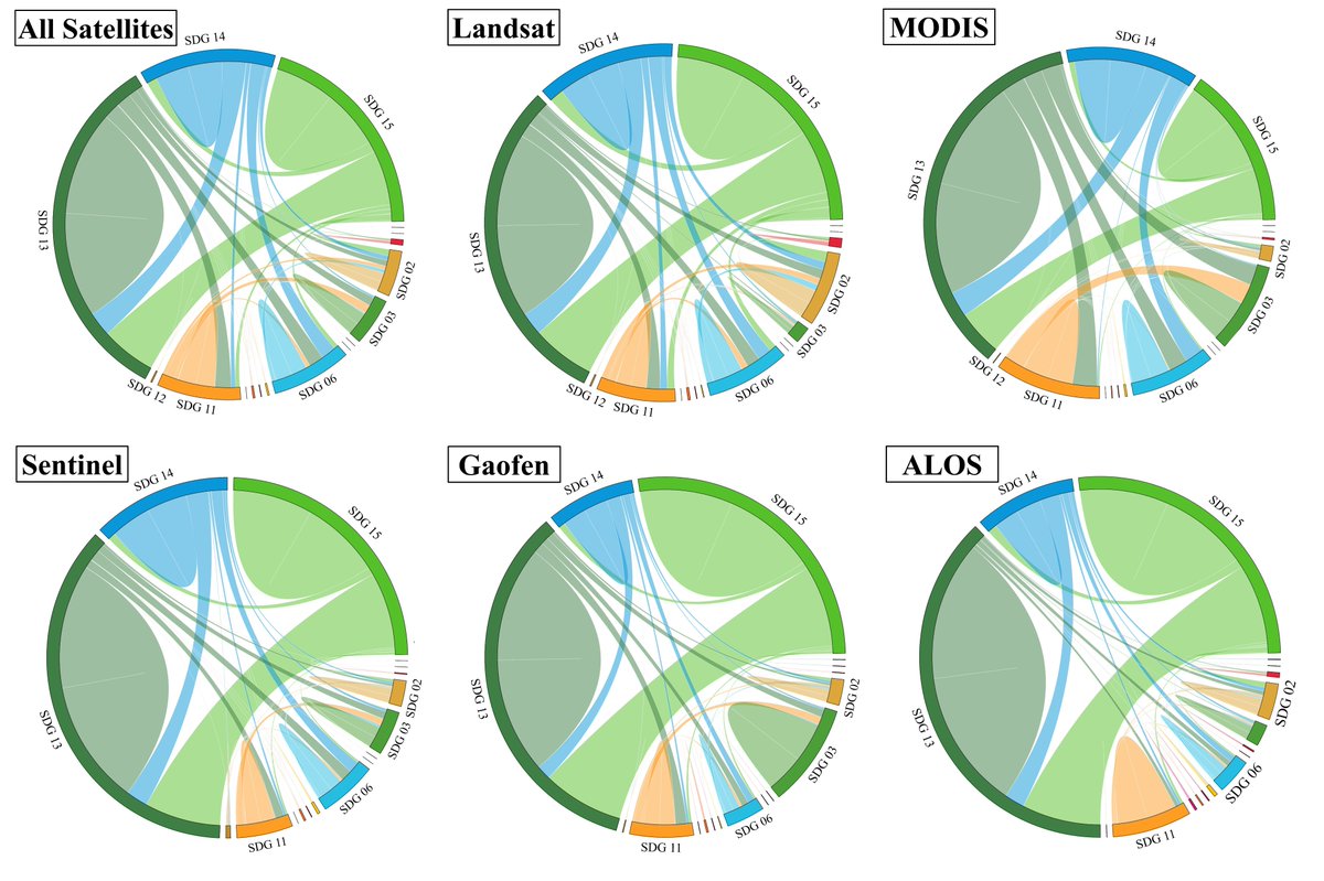
💡Highlights🛰️: A Review published by Journal of Remote Sensing (IF 8.8, Q1) delves deeper into Earth Observation satellite research to illustrate the full potential of Earth Observation data for accelerating Sustainable Development Goals progress, supporting human well-being,

💡Highlights🛰️: A Review published by Journal of Remote Sensing (IF 8.8, Q1) delves deeper into Earth Observation satellite research to illustrate the full potential of Earth Observation data for accelerating Sustainable Development Goals progress, supporting human well-being,
Journal of Remote Sensing (@journalofrs) 's Twitter Profile Photo

⚡️Highlights: Free Submission to Special Issue on Advances in Hyperspectral Remote Sensing: Intelligent Extraction and Applications by Journal of Remote Sensing 💡Guest Editors: Prof. Lianru Gao, Key Laboratory of Computational Optical Imaging Technology, Aerospace

⚡️Highlights: Free Submission to Special Issue on Advances in Hyperspectral Remote Sensing: Intelligent Extraction and Applications by Journal of Remote Sensing  

💡Guest Editors:
Prof. Lianru Gao, Key Laboratory of Computational Optical Imaging Technology, Aerospace
Journal of Remote Sensing (@journalofrs) 's Twitter Profile Photo

🌳Cover paper of Volume 2021, Journal of Remote Sensing : A review paper published by Journal of Remote Sensing summarizes two classes of near-real-time mapping methods, highlighting that recent satellite datasets such as the harmonized Landsat and Sentinel-2 (HLS) are promising

🌳Cover paper of Volume 2021, Journal of Remote Sensing : A review paper published by Journal of Remote Sensing summarizes two classes of near-real-time mapping methods, highlighting that recent satellite datasets such as the harmonized Landsat and Sentinel-2 (HLS) are promising
Journal of Remote Sensing (@journalofrs) 's Twitter Profile Photo

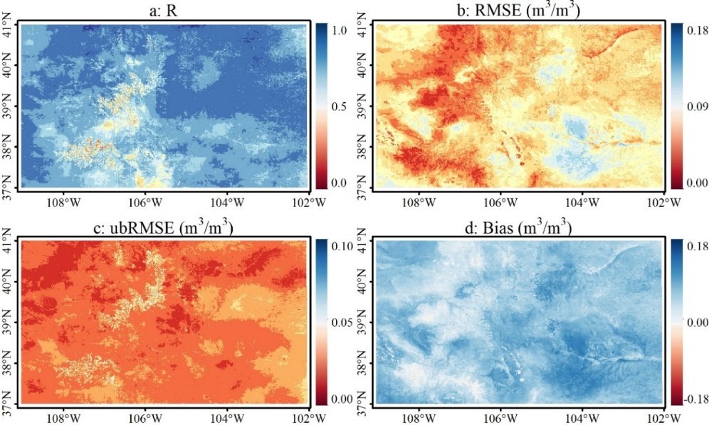
✨Generation of High-Resolution Surface Soil Moisture over Mountain Areas by Spatially Downscaling Remote Sensing Products Based on Land Surface Temperature–Vegetation Index Feature Space Highlights: 1⃣ A novel method for surface soil moisture(SSM) downscaling have been

✨Generation of High-Resolution Surface Soil Moisture over Mountain Areas by Spatially Downscaling Remote Sensing Products Based on Land Surface Temperature–Vegetation Index Feature Space

Highlights: 
1⃣ A novel method for surface soil moisture(SSM) downscaling have been
Journal of Remote Sensing (@journalofrs) 's Twitter Profile Photo

💡Transformer-Based Fast Mole Fraction of CO2 Retrievals from Satellite-Measured Spectra 🛰️Highlights: 1⃣Based on a coupled ATS-AIEM-TVG model, a unified multi-frequency backscatter and emission simulator called the Community Land Active Passive Microwave Radiative Transfer

💡Transformer-Based Fast Mole Fraction of CO2 Retrievals from Satellite-Measured Spectra

🛰️Highlights:
1⃣Based on a coupled ATS-AIEM-TVG model, a unified multi-frequency backscatter and emission simulator called the Community Land Active Passive Microwave Radiative Transfer
Journal of Remote Sensing (@journalofrs) 's Twitter Profile Photo

⚡️Highlights: A recent Journal of Remote Sensing (IF 8.8) study presents a Transformer-based AI model that retrieves atmospheric CO₂ from satellite spectra with unprecedented speed and accuracy—paving the way for real-time global carbon monitoring. (By Prof. Tao Ren) 🔑Keywords:

⚡️Highlights: A recent Journal of Remote Sensing (IF 8.8) study presents a Transformer-based AI model that retrieves atmospheric CO₂ from satellite spectra with unprecedented speed and accuracy—paving the way for real-time global carbon monitoring. (By Prof. Tao Ren)
🔑Keywords:
Journal of Remote Sensing (@journalofrs) 's Twitter Profile Photo

🛰️Highlights: Cover paper of Volume 2022 Issue3&4, Journal of Remote Sensing: The paper showed that tree growth is mainly reflected in the growth of the crown, i.e., the growth of branches. Compared to one-dimensional parameter growth (tree height, diameter at breast height, or

🛰️Highlights: Cover paper of Volume 2022 Issue3&4, Journal of Remote Sensing: The paper showed that tree growth is mainly reflected in the growth of the crown, i.e., the growth of branches. Compared to one-dimensional parameter growth (tree height, diameter at breast height, or
Journal of Remote Sensing (@journalofrs) 's Twitter Profile Photo

🛰️ Characterizing and Detecting Multiscenario Degradation of the Maidika Alpine Wetland Nature Reserve in the Qinghai–Tibet Plateau Using Landsat Time Series 1⃣ AW-CCD framework proposed to multi-scenarios degradation detection of alpine wetlands in terms of inter-annual area

🛰️ Characterizing and Detecting Multiscenario Degradation of the Maidika Alpine Wetland Nature Reserve in the Qinghai–Tibet Plateau Using Landsat Time Series
1⃣ AW-CCD framework proposed to multi-scenarios degradation detection of alpine wetlands in terms of inter-annual area
Journal of Remote Sensing (@journalofrs) 's Twitter Profile Photo

🛰️ Spatiotemporal Distribution of Submesoscale Eddies with Updated Interferometric Imaging Radar Altimeter Data 🪐 Submesoscale eddies (SEs) represent a potent force driving ocean vertical motion. However, the resolution limitations of conventional satellite data hinder the

🛰️ Spatiotemporal Distribution of Submesoscale Eddies with Updated Interferometric Imaging Radar Altimeter Data
🪐 Submesoscale eddies (SEs) represent a potent force driving ocean vertical motion. However, the resolution limitations of conventional satellite data hinder the
Journal of Remote Sensing (@journalofrs) 's Twitter Profile Photo

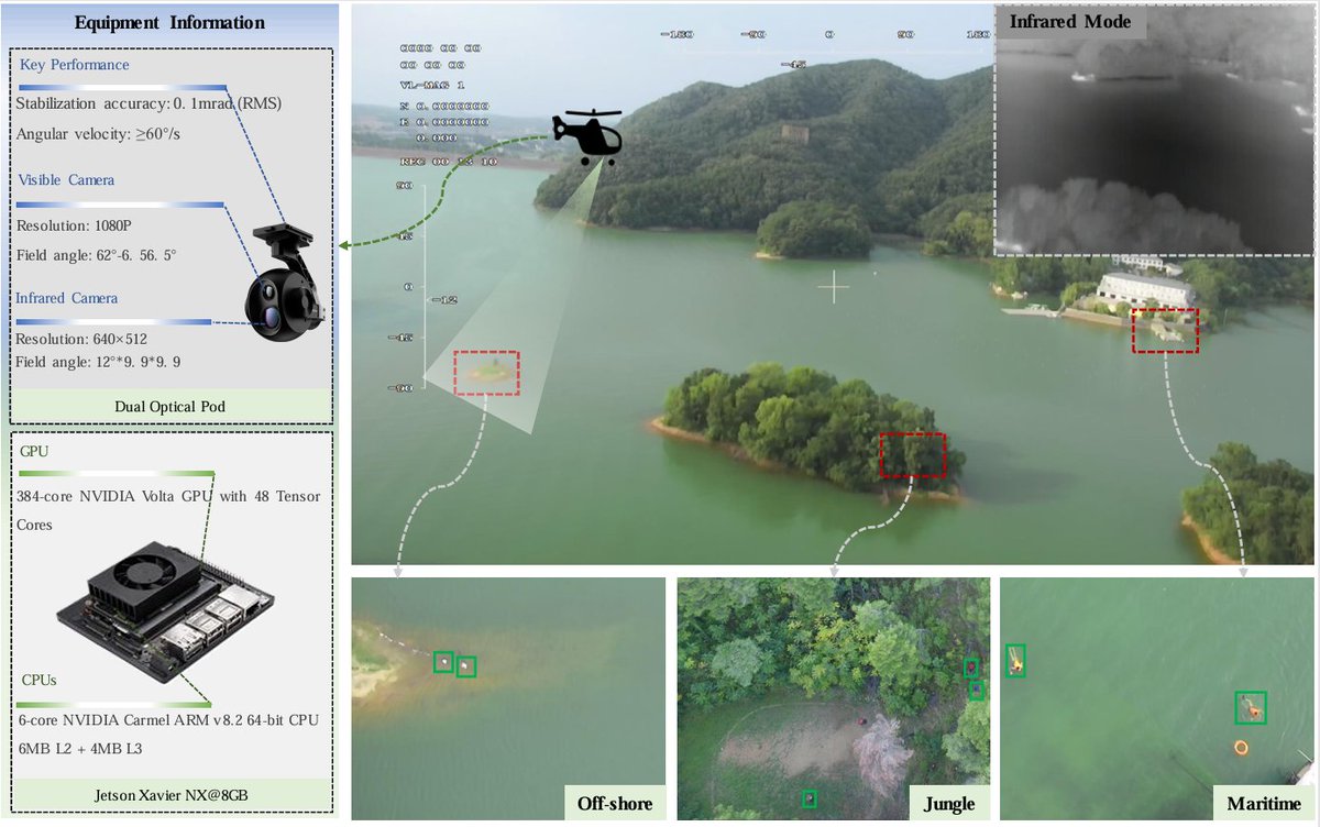
✈️Aerial Person Detection for Search and Rescue: Survey and Benchmarks 1⃣ First systematically evaluated the accuracy of deep learning models in the task of aerial person detection. 2⃣ Constructed a comprehensive benchmark testing framework that covers various aerial test

✈️Aerial Person Detection for Search and Rescue: Survey and Benchmarks
1⃣ First systematically evaluated the accuracy of deep learning models in the task of aerial person detection.
2⃣ Constructed a comprehensive benchmark testing framework that covers various aerial test
Journal of Remote Sensing (@journalofrs) 's Twitter Profile Photo

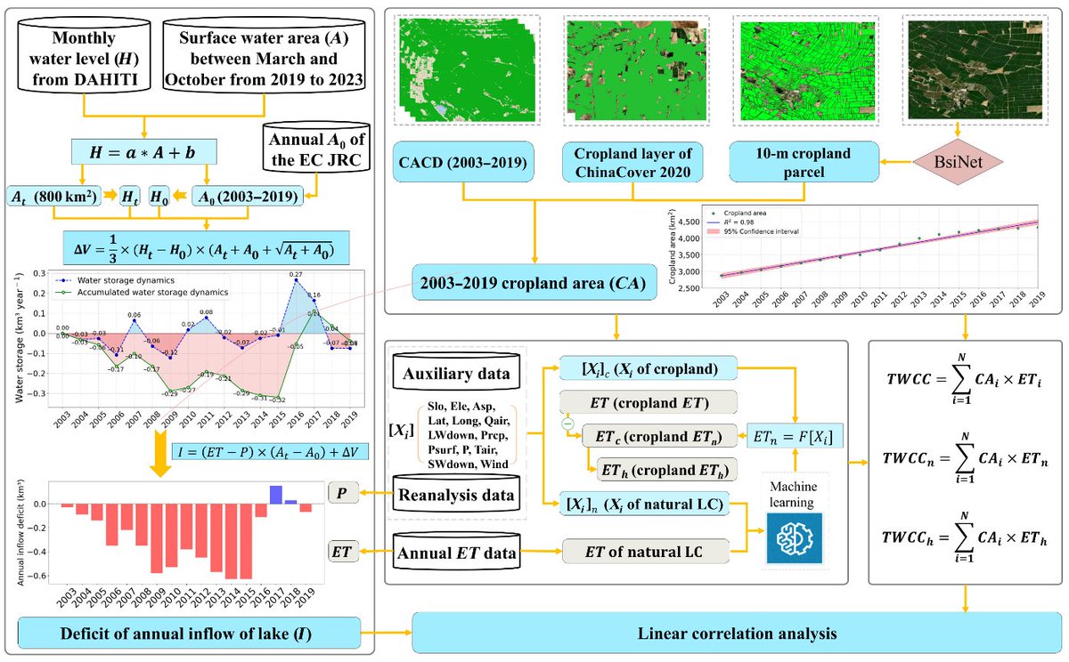
👉Title: Increasing Cropland Area and Its Associated Human-Induced Water Consumption Put Ebinur Lake at Risk of Drying Up ⚡️Highlights: A data-driver model designed to successfully quantify the contribution of natural and anthropogenic drivers on cropland evapotranspiration (ET)

👉Title: Increasing Cropland Area and Its Associated Human-Induced Water Consumption Put Ebinur Lake at Risk of Drying Up
⚡️Highlights: A data-driver model designed to successfully quantify the contribution of natural and anthropogenic drivers on cropland evapotranspiration (ET)
Journal of Remote Sensing (@journalofrs) 's Twitter Profile Photo

Title: Unsupervised Cross-Regional and Cross-Year Adaptation by Climate Indicator Discrepancy for Crop Classification Highlights: 1⃣A novel index was designed to quantify regional climate conditions, establishing a link between climate difference and spectral shift. 2⃣A method

Title: Unsupervised Cross-Regional and Cross-Year Adaptation by Climate Indicator Discrepancy for Crop Classification
Highlights:
1⃣A novel index was designed to quantify regional climate conditions, establishing a link between climate difference and spectral shift.
2⃣A method
Journal of Remote Sensing (@journalofrs) 's Twitter Profile Photo

From April 9 to 12, 2025, Dr. Lijun Zuo of the Aerospace Information Research Institute, Chinese Academy of Sciences, participated in the China-Brazil (NSFC-CONFAP) Amazon Bilateral Workshop in Belém, Brazil. The workshop addressed critical issues in the Amazon region, such as

Journal of Remote Sensing (@journalofrs) 's Twitter Profile Photo

⚡️Highlights: In this study, we pioneered the Seasonal Tree Height Neural Network (STHNN) integrating multi-source remote sensing data and SHAP optimization, and realized the dynamic seasonal monitoring of tree height in Shenzhen (R²=0.80, MAE=1.58 m), revealing the seasonal

⚡️Highlights: In this study, we pioneered the Seasonal Tree Height Neural Network (STHNN) integrating multi-source remote sensing data and SHAP optimization, and realized the dynamic seasonal monitoring of tree height in Shenzhen (R²=0.80, MAE=1.58 m), revealing the seasonal
Journal of Remote Sensing (@journalofrs) 's Twitter Profile Photo

🍃Title: Improved soybean mapping with spectral Gaussian mixture modeling 🌱Highlights: Integration of canopy greenness, water content, and chlorophyll characteristics, and use of improved Bhattacharyya Coefficient weights for robust global soybean mapping. 🔑Keywords:

🍃Title: Improved soybean mapping with spectral Gaussian mixture modeling
🌱Highlights: Integration of canopy greenness, water content, and chlorophyll characteristics, and use of improved Bhattacharyya Coefficient weights for robust global soybean mapping.
🔑Keywords:
Journal of Remote Sensing (@journalofrs) 's Twitter Profile Photo

💡Highlights:This study developed a simple and efficient multispectral remote sensing index, the Spartina alterniflora Index (SAI), which enhances the spectral contrast between red and near-infrared bands to enable accurate identification of small patches of Spartina

💡Highlights:This study developed a simple and efficient multispectral remote sensing index, the Spartina alterniflora Index (SAI), which enhances the spectral contrast between red and near-infrared bands to enable accurate identification of small patches of Spartina