CEDR Digital Corps (@cedrdigital) 's Twitter Profile
CEDR Digital Corps

@cedrdigital

Digital Helpers During Disasters to clarify, amplify, & inform.
Not 24x7▪501c3▪❤/RT🚫endorsement
facebook.com/CEDRdigital
universeodon.com/@CEDRdigital

ID: 904740870817120256

linkhttps://cedrdigitalcorps.org/donate/ calendar_today04-09-2017 16:20:07

48,48K Tweet

7,7K Followers

924 Following

San Joaquin County Office of Emergency Services (@sjc_oes) 's Twitter Profile Photo

As of 6:27pm- Fire on Corral Hollow Rd E of I580. Residents in the area E of I/580 between Corral Hollow Rd and S Tracy Blvd should leave now. Residents S of Tracy Blvd should be ready to leave. San Joaquin County Sheriff’s Office and Tracy Police Department are assisting with evacuations in the area.

San Joaquin County Office of Emergency Services (@sjc_oes) 's Twitter Profile Photo

Please follow their directions and leave if told to do so. A temporary evacuation site at Larch Clover Community Center - 11157 W Larch Rd, Tracy

San Joaquin County Office of Emergency Services (@sjc_oes) 's Twitter Profile Photo

A partir de las 6:27pm Incendio en Corral Hollow Rd al este de la I580. Los residentes en el área al este de la I/580 entre Corral Hollow Rd y S Tracy Blvd deben evacuar ahora. Los residentes al sur de Tracy Blvd deben estar listos para evacuar.

San Joaquin County Office of Emergency Services (@sjc_oes) 's Twitter Profile Photo

San Joaquin County Sheriff’s Office y Tracy Police Department están asistiendo con las evacuaciones en el área. Por favor, sigan sus instrucciones y evacúen si se les indica hacerlo. Se ha establecido un sitio de evacuación temporal en el Larch Clover Community Center - 11157 W Larch Rd, Tracy.

CAL FIRE SCU (@calfirescu) 's Twitter Profile Photo

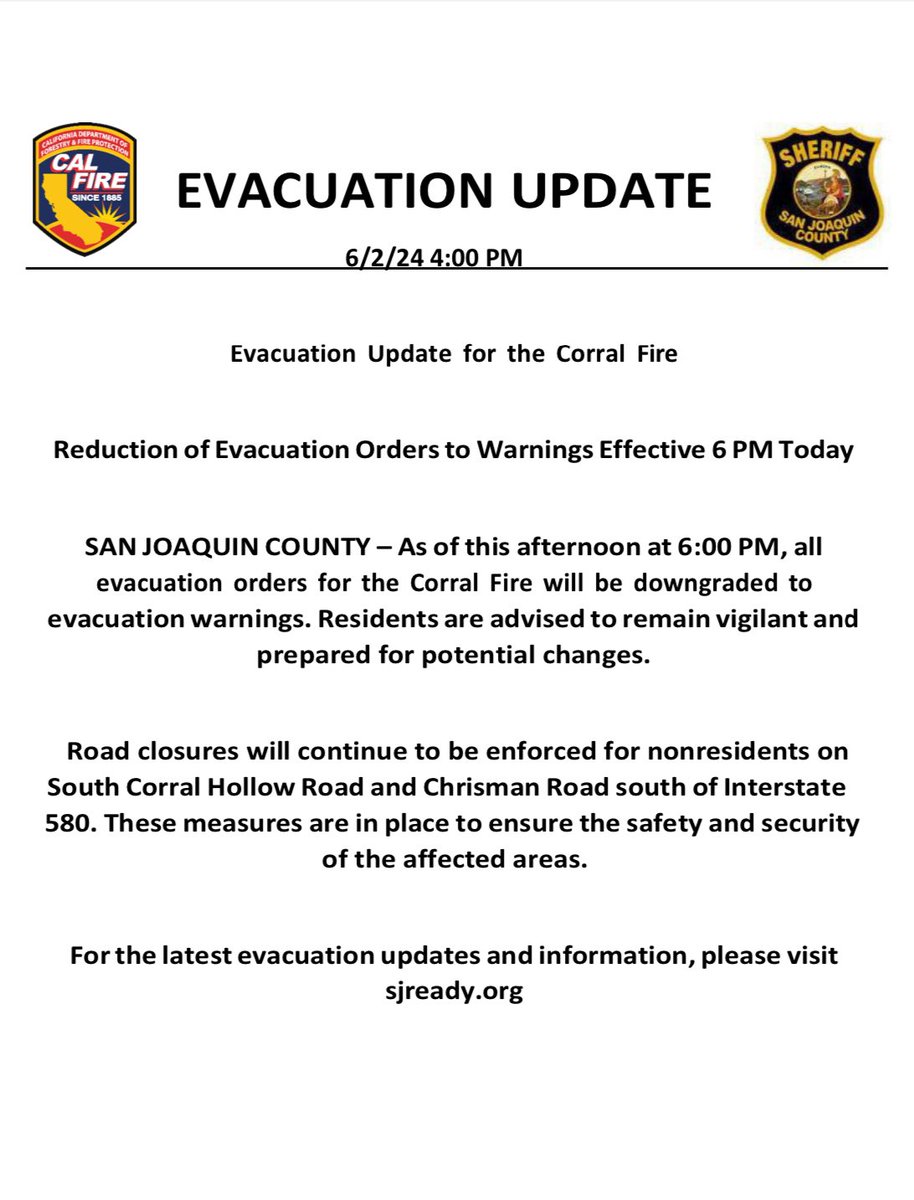
#CorralFire [update] near Lawrence Livermore National Labratory Site 300 southwest of Tracy (San Joaquin County) is now 8800 acres and 10% contained. In unified command with Alameda County Fire #CALFIRESCU EVACUATION information: sjready.org San Joaquin County Office of Emergency Services

#CorralFire [update] near Lawrence Livermore National Labratory Site 300 southwest of Tracy (San Joaquin County) is now 8800 acres and 10% contained. In unified command with <a href="/AlamedaCoFire/">Alameda County Fire</a> #CALFIRESCU

EVACUATION information: sjready.org
<a href="/SJC_OES/">San Joaquin County Office of Emergency Services</a>
CEDR Digital Corps (@cedrdigital) 's Twitter Profile Photo

#CorralFire #EvacuationOrder #EvacuationWarning #EvacuationMap Official San Joaquin county OES evacuation map app.perimeterplatform.com/incidents/poly…

CEDR Digital Corps (@cedrdigital) 's Twitter Profile Photo

What: Severe thunderstorms w/damaging winds, large hail, flooding and potential tornados Where: Midwest & South with highest risk for Oklahoma and AR-LA-TX border region More info: NWS Norman NWS Tulsa NWS Little Rock NWS Weather Prediction Center spc.noaa.gov/products/outlo… wpc.ncep.noaa.gov/qpf/ero.php?op…
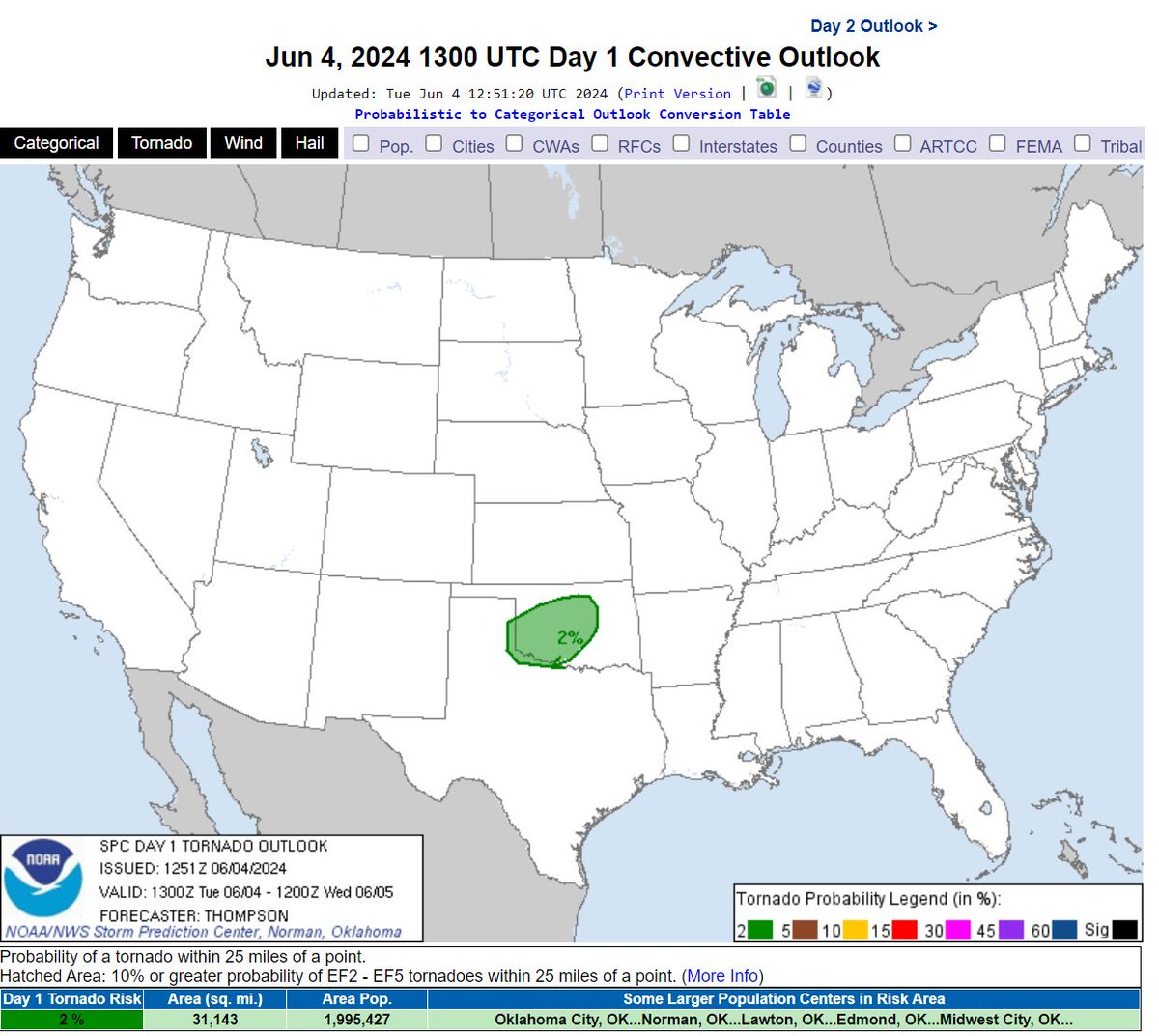
What: Severe thunderstorms w/damaging winds, large hail, flooding and potential tornados
Where: Midwest &amp; South with highest risk for Oklahoma and AR-LA-TX border region
More info: <a href="/NWSNorman/">NWS Norman</a> <a href="/NWSTulsa/">NWS Tulsa</a> <a href="/NWSLittleRock/">NWS Little Rock</a> <a href="/NWSWPC/">NWS Weather Prediction Center</a>

spc.noaa.gov/products/outlo…
wpc.ncep.noaa.gov/qpf/ero.php?op…
CEDR Digital Corps (@cedrdigital) 's Twitter Profile Photo

Qué: tormentas eléctricas severas con vientos dañinos, granizo grande, inundaciones y posibles tornados Dónde: Medio Oeste y Sur con mayor riesgo en OK y la frontera AR-LA-TX Más: NWS Norman NWS Tulsa NWS Little Rock NWS Weather Prediction Center spc.noaa.gov/products/outlo… wpc.ncep.noaa.gov/qpf/ero.php?op…
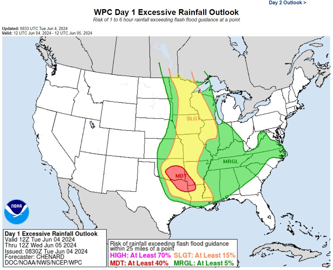
Qué: tormentas eléctricas severas con vientos dañinos, granizo grande, inundaciones y posibles tornados
Dónde: Medio Oeste y Sur con mayor riesgo en OK y la frontera AR-LA-TX

Más: <a href="/NWSNorman/">NWS Norman</a> <a href="/NWSTulsa/">NWS Tulsa</a> <a href="/NWSLittleRock/">NWS Little Rock</a> <a href="/NWSWPC/">NWS Weather Prediction Center</a> 

spc.noaa.gov/products/outlo…
wpc.ncep.noaa.gov/qpf/ero.php?op…
CEDR Digital Corps (@cedrdigital) 's Twitter Profile Photo

#NorthernCalifornia #NorCal #FireWx 🚩Red flag warning Saturday night into Sunday night. 🚩 🔥 #Sacramento Valley & adjacent foothills below 2000 ft late Sat night - Sun evening. #cawx x.com/NWSSacramento/…

CEDR Digital Corps (@cedrdigital) 's Twitter Profile Photo

🚩#RedFlagWarning is in effect for Eastern Lassen County today from 2 PM to 10 PM 🚩#RedFlagWarning is in effect for Northern Sacramento Valley, into Tehama and Glenn counties from Saturday evening through Monday afternoon. #CriticalFireWeather zurl.co/f3hO

CEDR Digital Corps (@cedrdigital) 's Twitter Profile Photo

🚩🔥 #RedFlagWarning conditions across AZ, UT, CO, NV and northern CA today. #FireMappers 🔥🚩 arcg.is/0iLbHL0 spc.noaa.gov/products/fire_…

🚩🔥 #RedFlagWarning conditions across AZ, UT, CO, NV and northern CA today. #FireMappers 🔥🚩

arcg.is/0iLbHL0
spc.noaa.gov/products/fire_…
CEDR Digital Corps (@cedrdigital) 's Twitter Profile Photo

🚩🔥 Condiciones de #RedFlagWarning en AZ, UT, CO, NV y el norte de CA hoy. #FireMappers 🔥🚩 arcg.is/0iLbHL0 spc.noaa.gov/products/fire_…

🚩🔥 Condiciones de #RedFlagWarning en AZ, UT, CO, NV y el norte de CA hoy. #FireMappers 🔥🚩

arcg.is/0iLbHL0
spc.noaa.gov/products/fire_…
CEDR Digital Corps (@cedrdigital) 's Twitter Profile Photo

#AeroFire Valley Springs Veterans Hall at 189 Pine Street for residents west of the town square. 🐶🐱Domestic animals can be taken to the Veterans Hall. 🐴🐄🐐Livestock can be taken to the Calaveras Fairgrounds zurl.co/FnW3

CEDR Digital Corps (@cedrdigital) 's Twitter Profile Photo

#AeroFire #CalaverasCounty 🚨🚨Evacuation order has been issued from Rock Creek Road from Highway 4 to Hunts Valley Road and O’byrnes Ferry Road to Copper Cove and Highway 4 West to Copperopolis Town Square🚨🚨 zurl.co/TyuW

CEDR Digital Corps (@cedrdigital) 's Twitter Profile Photo

#AeroFire #CalaverasCounty ⚠️⚠️Evacuation warning has been issued for east of Pool Station Road to Appaloosa and Bar 20.⚠️⚠️ zurl.co/0Q0k

CEDR Digital Corps (@cedrdigital) 's Twitter Profile Photo

#RailbridgeFire 🚨🚨EVACUATION ORDER🚨🚨 The Butte County Sheriff's Office is issuing an EVACUATION ORDER for the area of Crestmont Ct. in Zone 887 in Palermo due to a fire For more information, including a map of the area buttecounty.net/sheriff facebook.com/10004433932383…

NWS San Diego (@nwssandiego) 's Twitter Profile Photo

If you don't have adequate access to air conditioning, here are links to cooling center resources for each of the counties we cover: sandiegocounty.gov/content/sdc/hh… ocgov.com/cooling-centers capriverside.org/cool-centers dph.sbcounty.gov/extreme-heat-i…

NOLA Ready (@nolaready) 's Twitter Profile Photo

The National Weather Service expects the primary impacts from Francine to include heavy rain, high winds, & coastal flooding starting Tuesday night through Thursday morning. ⚠️ Finalize your storm prep by Tues. evening: • Gather supplies • Be ready to shelter in place • Check on elderly neighbors
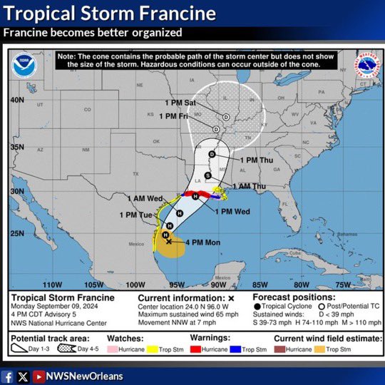
The <a href="/NWS/">National Weather Service</a> expects the primary impacts from Francine to include heavy rain, high winds, &amp; coastal flooding starting Tuesday night through Thursday morning.
⚠️ Finalize your storm prep by Tues. evening:
• Gather supplies
• Be ready to shelter in place
• Check on elderly neighbors