Deo (@deotectonics) 's Twitter Profile
Deo

@deotectonics

Active Faults | Earthquakes | Tectonics | Seismic Hazards | UP Diliman | PHIVOLCS | he/him

ID: 186760798

calendar_today04-09-2010 09:31:04

27,27K Tweet

1,1K Takipçi

541 Takip Edilen

Deo (@deotectonics) 's Twitter Profile Photo

Southwestern Luzon, Philippines, frequently experiences moderate to strong earthquakes, many of which are felt in Metro Manila, the nation's capital. This short article explores the sources of these seismic events. temblor.net/temblor/shaken…

temblor (@temblor) 's Twitter Profile Photo

Scientists from PHIVOLCS-DOST, the Philippines organization responsible for seismic and volcano hazard monitoring, explain what's going on with offshore earthquakes not far from the metro Manila area. temblor.net/temblor/shaken…

Deo (@deotectonics) 's Twitter Profile Photo

We wrote an article explaining why earthquakes (many of which are felt in Metro Manila) occur in the southwestern Luzon region, Philippines.

Joseph Çiprut (@mindthrust) 's Twitter Profile Photo

Just experienced a 7.7 strength #earthquake in #Bangkok for close to 3 minutes. Its epicenter was Mandalay, Myanmar, over 1200 kms from here. Despite the distance it swayed buildings; caused cracks, forced evacuations and rooftop pools cascaded much water to down below. Scary!

andrean (@andreanjtk) 's Twitter Profile Photo

This figure informs us about the historical and current seismicity in Myanmar especially in the Sagaing fault. Also, the Mag 7.7 was strongly felt until 2000 km where massive damages can be found in Thailand.

This figure informs us about the historical and current seismicity in Myanmar especially in the Sagaing fault. Also, the Mag 7.7 was strongly felt until 2000 km where massive damages can be found in Thailand.
Simone Atzori (@simoneatzori73) 's Twitter Profile Photo

Scenario (**NOT REAL DATA**) of deformations for the today M 7.7, #Myanmar #earthquake (up to 1 m on surface), based on #USGS finite-source results. Here also the #Sentinel1 acquisition schedule for #InSAR results terremoti.ingv.it/en/finitesourc… with Andrea Antonioli
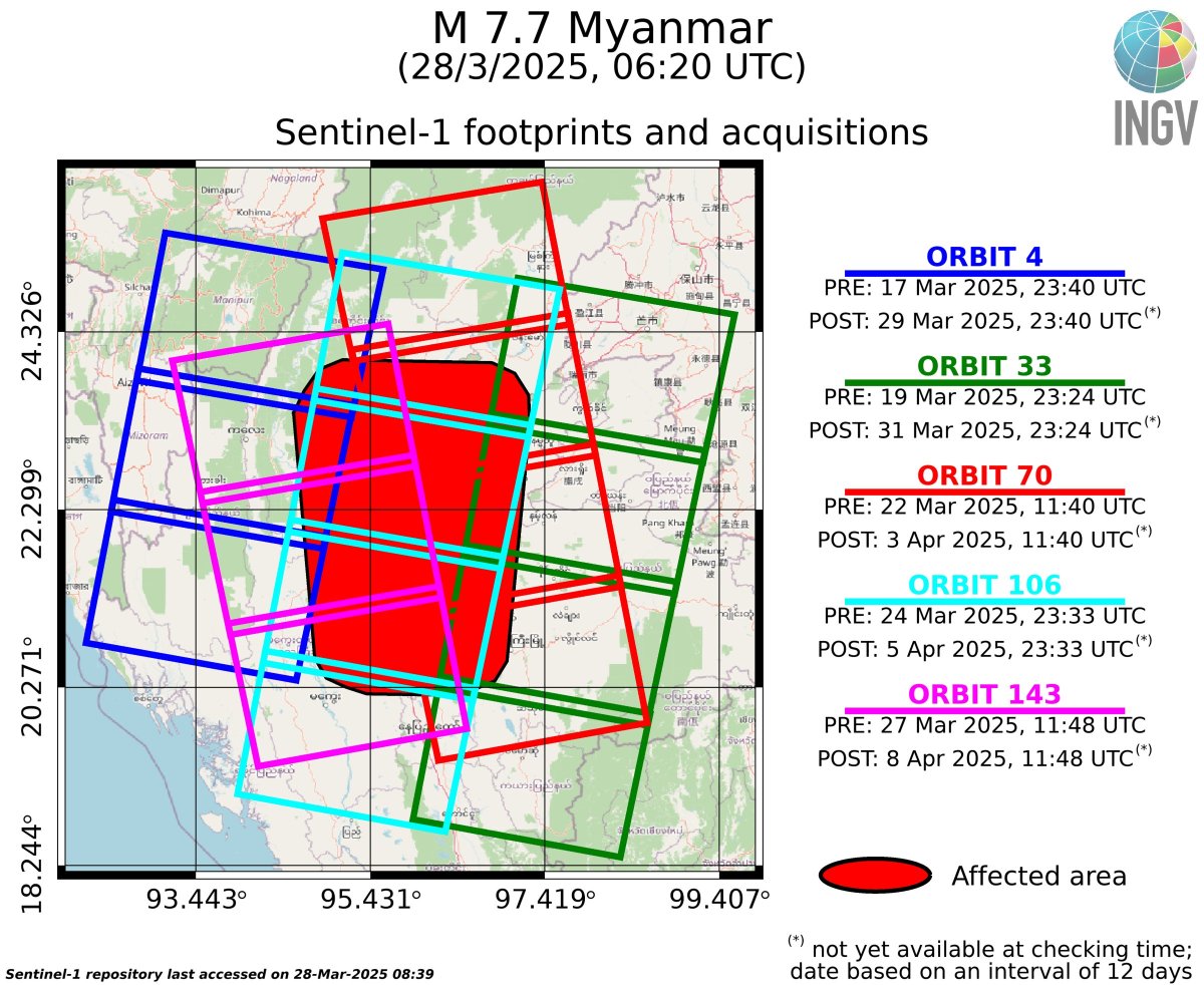
Scenario (**NOT REAL DATA**) of deformations for the today M 7.7, #Myanmar #earthquake (up to 1 m on surface), based on #USGS finite-source results. 
Here also the #Sentinel1 acquisition schedule for  #InSAR results

terremoti.ingv.it/en/finitesourc…

with <a href="/antandre71/">Andrea Antonioli</a>
Deo (@deotectonics) 's Twitter Profile Photo

GPR x precise leveling along the creeping segment of the West Valley Fault. Like the recent earthquake in Myanmar, this fault poses a significant threat to Metro Manila. The recent earthquake serves as a reminder of this risk, highlighting the importance of continuous monitoring.

GPR x precise leveling along the creeping segment of the West Valley Fault. Like the recent earthquake in Myanmar, this fault poses a significant threat to Metro Manila. The recent earthquake serves as a reminder of this risk, highlighting the importance of continuous monitoring.
GeoGeorge (@geogeorgeology) 's Twitter Profile Photo

Possible surface rupture as a result of the M7.7 earthquake in Myanmar (?) Photos here appear to show right lateral offset in the roads.

GeoGeorge (@geogeorgeology) 's Twitter Profile Photo

Surface rupture: video shows right lateral displacement in a wall and building after the M7.7 earthquake in #Myanmar Credit: huuu71616 on TikTok #MyanmarEarthquake

GeoGeorge (@geogeorgeology) 's Twitter Profile Photo

A user from Myanmar filmed what appears to be offset in a water channel caused by the earthquake. Looks like the fault surface was also exposed Credit: okarun011 on TikTok #MyanmarEarthquake

Thu Thu Aung (@thuttag) 's Twitter Profile Photo

Apocalyptic scenes from Mandalay, MM. Only seeing small snippets of what is happening, given minimal internet or electricity. Supplies of food and water running scarce. Lack of machinery or govt support to find people under buildings. #WhatsHappeningInMyanmar #MyanmarEarthquake

LEEZIXIN (@zaxonlee) 's Twitter Profile Photo

Preliminary coseismic displacements and fault offset of 2025 Myanmar earthquake from Copernicus EU @ESA #Sentinel2 images, processed by NTU Taiwan GEOG #Copernicus 1. Rupture propagated from N to S 2. Maximum offset >4m 3. Two peaks of fault offset 4. Rupture length >300km
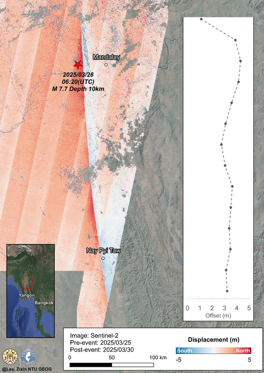
Preliminary coseismic displacements and fault offset of 2025 Myanmar earthquake from <a href="/CopernicusEU/">Copernicus EU</a> @ESA #Sentinel2 images, processed by <a href="/NTU_TW/">NTU Taiwan</a> GEOG
#Copernicus  

1. Rupture propagated from N to S 
2. Maximum offset &gt;4m  
3. Two peaks of fault offset 
4. Rupture length &gt;300km
GeoGeorge (@geogeorgeology) 's Twitter Profile Photo

The #MyanmarEarthquake broke a seismic gap identified by Hurukawa and Maung (2011), called the Meiktila Gap. They prev. estimated a M7.9 earthquake here. Possibly, the last EQ on the gap was in 1839, Mw7.9–8.3. Credit: Hubbard & Bradley, DtA on Wikipedia

The #MyanmarEarthquake broke a seismic gap identified by Hurukawa and Maung (2011), called the Meiktila Gap. They prev. estimated a M7.9 earthquake here.

Possibly, the last EQ on the gap was in 1839, Mw7.9–8.3.

Credit: Hubbard &amp; Bradley, DtA on Wikipedia
GeoGeorge (@geogeorgeology) 's Twitter Profile Photo

Updated USGS Earthquakes model indicate more than 400km of rupture. The southern extent is near Pyu City. Plotting the model against Tun & Watkinson diagram, looks like it broke Pyu segment. This section previously broke in 1930 M7.5 quake! Seismic gap nearby .. #MyanmarEarthquake
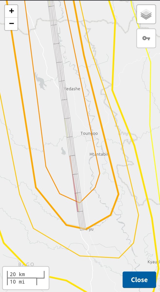
Updated <a href="/USGS_Quakes/">USGS Earthquakes</a> model indicate more than 400km of rupture. The southern extent is near Pyu City. Plotting the model against Tun &amp; Watkinson diagram, looks like it broke Pyu segment. This section previously broke in 1930 M7.5 quake!

Seismic gap nearby ..

#MyanmarEarthquake
Deo (@deotectonics) 's Twitter Profile Photo

Updated Optical image correlation using Sentinel-2 data N-S displacements along the Sagaing Fault suggest a surface rupture of approximately 500 km — unusually long fault rupture for a magnitude 7.7 earthquake! The maximum ground offset reaches more than 4 m. -DETect Faults

Updated Optical image correlation using Sentinel-2 data

N-S displacements along the Sagaing Fault suggest a surface rupture of approximately 500 km — unusually long fault rupture for a magnitude 7.7 earthquake! 

The maximum ground offset reaches more than 4 m.

-DETect Faults
Deo (@deotectonics) 's Twitter Profile Photo

Likely surface rupture of the 2025 M7.7 Myanmar earthquake caught on cam! The shift of the ground to the right is so striking! Source: facebook.com/share/v/18gqF7…