PHIVOLCS-DOST(@phivolcs_dost) 's Twitter Profileg
PHIVOLCS-DOST

@phivolcs_dost

PHIVOLCS is the service institute of the DOST for monitoring and mitigation of volcanic eruptions, earthquakes and tsunami.

ID:802064401

linkhttps://www.phivolcs.dost.gov.ph/ calendar_today04-09-2012 08:40:50

97,9K Tweets

833,8K Followers

60 Following

Follow People
PHIVOLCS-DOST(@phivolcs_dost) 's Twitter Profile Photo


Earthquake Information No.1
Date and Time: 30 April 2024 - 06:47 PM
Magnitude = 1.8
Depth = 011 km
Location = 15.47°N, 121.30°E - 004 km N 70° W of Gabaldon (Nueva Ecija)

earthquake.phivolcs.dost.gov.ph/2024_Earthquak…
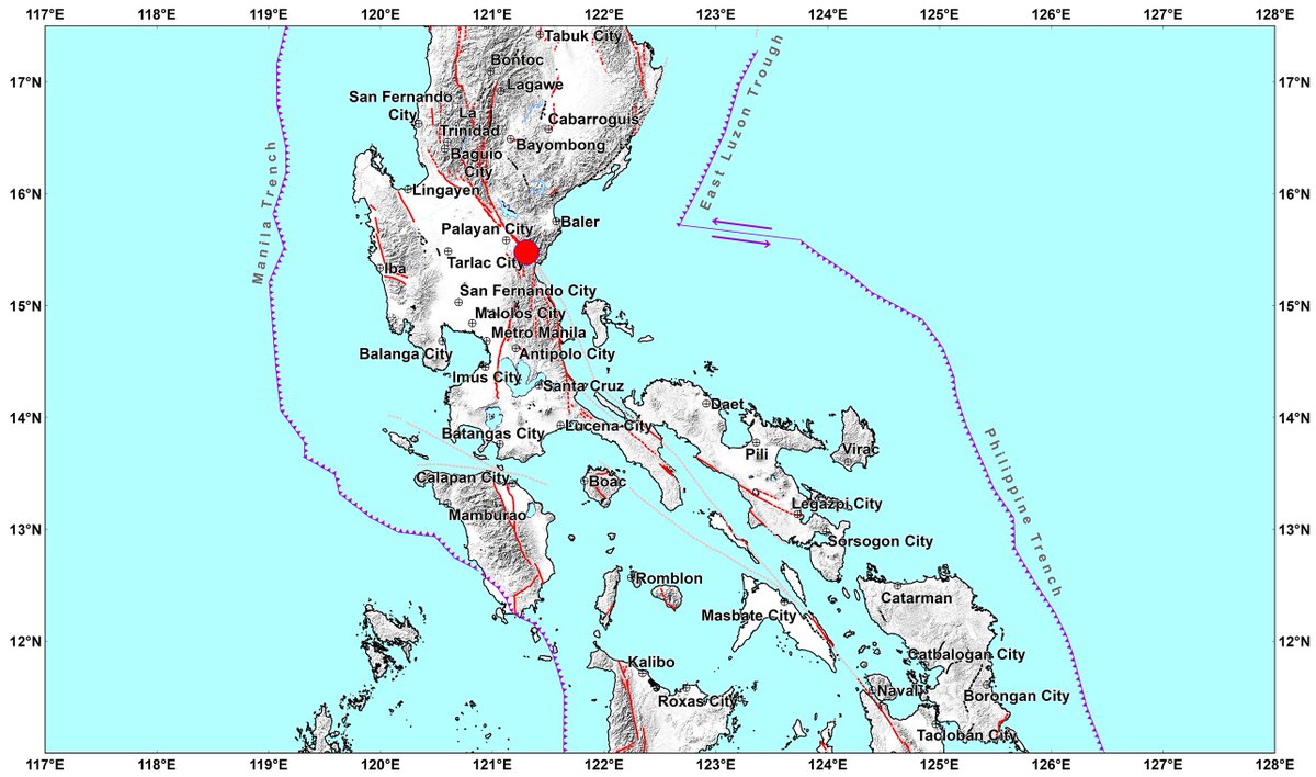
#EarthquakePH #EarthquakeNuevaEcija Earthquake Information No.1 Date and Time: 30 April 2024 - 06:47 PM Magnitude = 1.8 Depth = 011 km Location = 15.47°N, 121.30°E - 004 km N 70° W of Gabaldon (Nueva Ecija) earthquake.phivolcs.dost.gov.ph/2024_Earthquak…
account_circle
PHIVOLCS-DOST(@phivolcs_dost) 's Twitter Profile Photo


Earthquake Information No.1
Date and Time: 30 April 2024 - 05:20 PM
Magnitude = 3.5
Depth = 009 km
Location = 05.29°N, 126.43°E - 108 km S 79° E of Sarangani Island (Municipality Of Sarangani) (Davao Occidental)

earthquake.phivolcs.dost.gov.ph/2024_Earthquak…

#EarthquakePH #EarthquakeDavaoOccidental Earthquake Information No.1 Date and Time: 30 April 2024 - 05:20 PM Magnitude = 3.5 Depth = 009 km Location = 05.29°N, 126.43°E - 108 km S 79° E of Sarangani Island (Municipality Of Sarangani) (Davao Occidental) earthquake.phivolcs.dost.gov.ph/2024_Earthquak…
account_circle
PHIVOLCS-DOST(@phivolcs_dost) 's Twitter Profile Photo


Earthquake Information No.1
Date and Time: 30 April 2024 - 05:04 PM
Magnitude = 2.8
Depth = 018 km
Location = 10.88°N, 125.84°E - 020 km N 39° E of Homonhon Island (Guiuan) (Eastern Samar)

earthquake.phivolcs.dost.gov.ph/2024_Earthquak…

#EarthquakePH #EarthquakeEasternSamar Earthquake Information No.1 Date and Time: 30 April 2024 - 05:04 PM Magnitude = 2.8 Depth = 018 km Location = 10.88°N, 125.84°E - 020 km N 39° E of Homonhon Island (Guiuan) (Eastern Samar) earthquake.phivolcs.dost.gov.ph/2024_Earthquak…
account_circle
PHIVOLCS-DOST(@phivolcs_dost) 's Twitter Profile Photo


Earthquake Information No.1
Date and Time: 30 April 2024 - 04:04 PM
Magnitude = 1.5
Depth = 025 km
Location = 08.56°N, 126.20°E - 009 km N 68° E of Barobo (Surigao Del Sur)

earthquake.phivolcs.dost.gov.ph/2024_Earthquak…

#EarthquakePH #EarthquakeSurigaoDelSur Earthquake Information No.1 Date and Time: 30 April 2024 - 04:04 PM Magnitude = 1.5 Depth = 025 km Location = 08.56°N, 126.20°E - 009 km N 68° E of Barobo (Surigao Del Sur) earthquake.phivolcs.dost.gov.ph/2024_Earthquak…
account_circle
PHIVOLCS-DOST(@phivolcs_dost) 's Twitter Profile Photo


Earthquake Information No.1
Date and Time: 30 April 2024 - 02:24 PM
Magnitude = 2.7
Depth = 133 km
Location = 06.07°N, 125.87°E - 024 km S 54° E of Don Marcelino (Davao Occidental)

earthquake.phivolcs.dost.gov.ph/2024_Earthquak…

#EarthquakePH #EarthquakeDavaoOccidental Earthquake Information No.1 Date and Time: 30 April 2024 - 02:24 PM Magnitude = 2.7 Depth = 133 km Location = 06.07°N, 125.87°E - 024 km S 54° E of Don Marcelino (Davao Occidental) earthquake.phivolcs.dost.gov.ph/2024_Earthquak…
account_circle
PHIVOLCS-DOST(@phivolcs_dost) 's Twitter Profile Photo


Earthquake Information No.1
Date and Time: 30 April 2024 - 01:45 PM
Magnitude = 3.1
Depth = 034 km
Location = 09.85°N, 126.51°E - 040 km N 79° E of General Luna (Surigao Del Norte)

earthquake.phivolcs.dost.gov.ph/2024_Earthquak…

#EarthquakePH #EarthquakeSurigaoDelNorte Earthquake Information No.1 Date and Time: 30 April 2024 - 01:45 PM Magnitude = 3.1 Depth = 034 km Location = 09.85°N, 126.51°E - 040 km N 79° E of General Luna (Surigao Del Norte) earthquake.phivolcs.dost.gov.ph/2024_Earthquak…
account_circle
PHIVOLCS-DOST(@phivolcs_dost) 's Twitter Profile Photo


Earthquake Information No.1
Date and Time: 30 April 2024 - 11:45 AM
Magnitude = 2.4
Depth = 035 km
Location = 19.33°N, 121.37°E - 014 km N 57° W of Calayan (Cagayan)

earthquake.phivolcs.dost.gov.ph/2024_Earthquak…

#EarthquakePH #EarthquakeCagayan Earthquake Information No.1 Date and Time: 30 April 2024 - 11:45 AM Magnitude = 2.4 Depth = 035 km Location = 19.33°N, 121.37°E - 014 km N 57° W of Calayan (Cagayan) earthquake.phivolcs.dost.gov.ph/2024_Earthquak…
account_circle
PHIVOLCS-DOST(@phivolcs_dost) 's Twitter Profile Photo

DOST-PHIVOLCS signed a Memorandum of Understanding with the University of Perpetual Help System DALTA - Las Piñas (UPHSD-LP) for the 'Development of Underwater Sensor Network for Tsunami Detection through Ground Station Terrestrial and Nanosatellite Communication.'

DOST-PHIVOLCS signed a Memorandum of Understanding with the University of Perpetual Help System DALTA - Las Piñas (UPHSD-LP) for the 'Development of Underwater Sensor Network for Tsunami Detection through Ground Station Terrestrial and Nanosatellite Communication.'
account_circle
PHIVOLCS-DOST(@phivolcs_dost) 's Twitter Profile Photo


Earthquake Information No.1
Date and Time: 30 April 2024 - 11:19 AM
Magnitude = 2.6
Depth = 035 km
Location = 12.91°N, 124.44°E - 027 km N 18° E of Biri (Northern Samar)

earthquake.phivolcs.dost.gov.ph/2024_Earthquak…

#EarthquakePH #EarthquakeNorthernSamar Earthquake Information No.1 Date and Time: 30 April 2024 - 11:19 AM Magnitude = 2.6 Depth = 035 km Location = 12.91°N, 124.44°E - 027 km N 18° E of Biri (Northern Samar) earthquake.phivolcs.dost.gov.ph/2024_Earthquak…
account_circle
PHIVOLCS-DOST(@phivolcs_dost) 's Twitter Profile Photo


Earthquake Information No.1
Date and Time: 30 April 2024 - 10:05 AM
Magnitude = 2.0
Depth = 027 km
Location = 09.07°N, 126.09°E - 009 km S 88° W of City Of Tandag (Surigao Del Sur)

earthquake.phivolcs.dost.gov.ph/2024_Earthquak…

#EarthquakePH #EarthquakeSurigaoDelSur Earthquake Information No.1 Date and Time: 30 April 2024 - 10:05 AM Magnitude = 2.0 Depth = 027 km Location = 09.07°N, 126.09°E - 009 km S 88° W of City Of Tandag (Surigao Del Sur) earthquake.phivolcs.dost.gov.ph/2024_Earthquak…
account_circle
PHIVOLCS-DOST(@phivolcs_dost) 's Twitter Profile Photo


Earthquake Information No.1
Date and Time: 30 April 2024 - 09:32 AM
Magnitude = 3.0
Depth = 038 km
Location = 04.98°N, 126.76°E - 153 km S 69° E of Sarangani Island (Municipality Of Sarangani) (Davao Occidental)

earthquake.phivolcs.dost.gov.ph/2024_Earthquak…

#EarthquakePH #EarthquakeDavaoOccidental Earthquake Information No.1 Date and Time: 30 April 2024 - 09:32 AM Magnitude = 3.0 Depth = 038 km Location = 04.98°N, 126.76°E - 153 km S 69° E of Sarangani Island (Municipality Of Sarangani) (Davao Occidental) earthquake.phivolcs.dost.gov.ph/2024_Earthquak…
account_circle
PHIVOLCS-DOST(@phivolcs_dost) 's Twitter Profile Photo


Earthquake Information No.1
Date and Time: 30 April 2024 - 09:20 AM
Magnitude = 1.9
Depth = 028 km
Location = 10.22°N, 125.90°E - 027 km N 34° W of Santa Monica (Surigao Del Norte)

earthquake.phivolcs.dost.gov.ph/2024_Earthquak…

#EarthquakePH #EarthquakeSurigaoDelNorte Earthquake Information No.1 Date and Time: 30 April 2024 - 09:20 AM Magnitude = 1.9 Depth = 028 km Location = 10.22°N, 125.90°E - 027 km N 34° W of Santa Monica (Surigao Del Norte) earthquake.phivolcs.dost.gov.ph/2024_Earthquak…
account_circle
PHIVOLCS-DOST(@phivolcs_dost) 's Twitter Profile Photo


Earthquake Information No.1
Date and Time: 30 April 2024 - 09:17 AM
Magnitude = 3.0
Depth = 001 km
Location = 05.69°N, 124.75°E - 033 km S 54° W of Maasim (Sarangani)

earthquake.phivolcs.dost.gov.ph/2024_Earthquak…

#EarthquakePH #EarthquakeSarangani Earthquake Information No.1 Date and Time: 30 April 2024 - 09:17 AM Magnitude = 3.0 Depth = 001 km Location = 05.69°N, 124.75°E - 033 km S 54° W of Maasim (Sarangani) earthquake.phivolcs.dost.gov.ph/2024_Earthquak…
account_circle
PHIVOLCS-DOST(@phivolcs_dost) 's Twitter Profile Photo


Earthquake Information No.1
Date and Time: 30 April 2024 - 08:35 AM
Magnitude = 3.7
Depth = 001 km
Location = 04.95°N, 126.56°E - 134 km S 64° E of Sarangani Island (Municipality Of Sarangani) (Davao Occidental)

earthquake.phivolcs.dost.gov.ph/2024_Earthquak…

#EarthquakePH #EarthquakeDavaoOccidental Earthquake Information No.1 Date and Time: 30 April 2024 - 08:35 AM Magnitude = 3.7 Depth = 001 km Location = 04.95°N, 126.56°E - 134 km S 64° E of Sarangani Island (Municipality Of Sarangani) (Davao Occidental) earthquake.phivolcs.dost.gov.ph/2024_Earthquak…
account_circle
PHIVOLCS-DOST(@phivolcs_dost) 's Twitter Profile Photo


Earthquake Information No.1
Date and Time: 30 April 2024 - 08:16 AM
Magnitude = 2.2
Depth = 022 km
Location = 17.42°N, 120.60°E - 001 km North of Pilar (Abra)

earthquake.phivolcs.dost.gov.ph/2024_Earthquak…

#EarthquakePH #EarthquakeAbra Earthquake Information No.1 Date and Time: 30 April 2024 - 08:16 AM Magnitude = 2.2 Depth = 022 km Location = 17.42°N, 120.60°E - 001 km North of Pilar (Abra) earthquake.phivolcs.dost.gov.ph/2024_Earthquak…
account_circle