Cape Pine Weather
@capepineweather
Weather Observations and Comments. (Ricky Myrick)
ID: 2306390431
http://www.capepine.com/weather.htm 23-01-2014 11:07:58
1,1K Tweet
506 Followers
57 Following
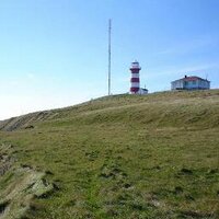
 on Twitter photo #NLwx
peak wind gust at Cape Pine 116km/h at 0935.
Snow ~ 12cm
<a href=\"/rcbstormpost/\">Rodney Barney</a>")
 's Twitter Profile Photo")
 on Twitter photo While not the widespread intense winds of some recent storms, there were still some solid gusts over the past 24 hrs.
Peak 128 km/h at St. Anthony Airport marked the highest at that location since Dec 6, 2024. #nlwx")
Once again wind was high on S. Avalon. #nlwx peak gust at Cape Pine 129km/h Rodney Barney
 on Twitter photo Once again wind was high on S. Avalon. #nlwx
peak gust at Cape Pine 129km/h
<a href=\"/rcbstormpost/\">Rodney Barney</a>")
 on Twitter photo #NLwx
Peak wind gust from the south at Cape Pine 129km/h at 9am
Winds have dropped dramatically now. Seems to be changing direction.")
 on Twitter photo Peak gust so far at Cape Pine
142km/h
#NLwx")
 's Twitter Profile Photo")
 's Twitter Profile Photo")
 on Twitter photo 10cm overnight at Cape Pine and S. Avalon, bit more than forecasted by ECCC. A unique occasion to be able to measure it - winds light NE.
#NLwx")
 on Twitter photo Totals from the latest winter storm; appreciate the help from the volunteers out there as usual. YKWYA 🙂
Also of note, 328 cm so far this season at St. John's #YYT; 434 cm Gander West. About 40-60% more than the avg for this point in the season.
dd.weather.gc.ca/20260219/WXO-D… #nlwx")
 's Twitter Profile Photo")
 on Twitter photo 36.2cm of snow as of 8:30am in Paradise this morning. My heated rain cone is measuring 28.0mm water equivalent. 4.6cm accumulation of snow in the last hour. #NLwx")
Numbers from the latest blockbuster storm: dd.weather.gc.ca/today/bulletin…. With 165.2 cm Feb 1-22, St. John’s #YYT is now <5 cm from its snowiest February on record (170.1 cm, 2006) and closing in on its snowiest calendar month (173.4 cm, Dec 2000). A few more days to get there! #nlwx
 on Twitter photo Numbers from the latest blockbuster storm: dd.weather.gc.ca/today/bulletin….
With 165.2 cm Feb 1-22, St. John’s #YYT is now <5 cm from its snowiest February on record (170.1 cm, 2006) and closing in on its snowiest calendar month (173.4 cm, Dec 2000). A few more days to get there! #nlwx")
2 years ago today a significant freezing rain storm impacted the extreme Southern Avalon. Ice accretion was about 20mm on exposed surfaces combined with E winds of 80km/h. Resulting in approximately 55 Newfoundland Power poles needing replacement at St. Shotts & Cape Pine. #NLwx
 on Twitter photo 2 years ago today a significant freezing rain storm impacted the extreme Southern Avalon. Ice accretion was about 20mm on exposed surfaces combined with E winds of 80km/h. Resulting in approximately 55 <a href=\"/NFPower/\">Newfoundland Power</a> poles needing replacement at St. Shotts & Cape Pine. #NLwx")