alex (@benjidad) 's Twitter Profile
alex

@benjidad

Volunteer on Map mastodon.social/@husni

ID: 150463035

calendar_today01-06-2010 00:39:49

2,2K Tweet

636 Followers

1,1K Following

₊‧ D I N ‧₊ (@adinduhhh) 's Twitter Profile Photo

Lately, aku sering banget dapet DM dari teman teman yang nanya “Gimana sih caranya mulai bikin game?” Aku ngerti rasa penasarannya, karena aku juga dulu bingung mau mulai dari mana. Jadi kali ini aku mau share program belajar bikin game yang menurutku wajib dicobaaaa!!

Lately, aku sering banget dapet DM dari teman teman yang nanya

“Gimana sih caranya mulai bikin game?”

Aku ngerti rasa penasarannya, karena aku juga dulu bingung mau mulai dari mana. Jadi kali ini aku mau share program belajar bikin game yang menurutku wajib dicobaaaa!!
Remote Sensing MDPI (@remotesens_mdpi) 's Twitter Profile Photo

💒💒 Assessment of #Rooftop #Photovoltaic Potential Considering #Building Functions ✍️ Zhixin Zhang et al. 🔗 brnw.ch/21wSC4R

💒💒 Assessment of #Rooftop #Photovoltaic Potential Considering #Building Functions

✍️ Zhixin Zhang et al.
🔗 brnw.ch/21wSC4R
Historia.ID (@historia_id) 's Twitter Profile Photo

Haji Misbach Meninggal Dunia Hari ini dalam sejarah, 24 Mei 1926, Haji Misbach meninggal dunia. Dia seorang haji progresif yang membela rakyat kecil. Haji Misbach beberapa kali masuk penjara sejak mempublikasikan kartun di Islam Bergerak pada 20 April 1919. Kartun ini menggugat

Haji Misbach Meninggal Dunia

Hari ini dalam sejarah, 24 Mei 1926, Haji Misbach meninggal dunia. Dia seorang haji progresif yang membela rakyat kecil.

Haji Misbach beberapa kali masuk penjara sejak mempublikasikan kartun di Islam Bergerak pada 20 April 1919. Kartun ini menggugat
Forensic Architecture (@forensicarchi) 's Twitter Profile Photo

FA has documented a pattern of Israeli attacks on areas into which they have previously instructed civilians in Gaza to evacuate. Our research confirms that the Israeli military carried out multiple attacks in areas towards which civilians had been directed, either on the same

IFRC (@ifrc) 's Twitter Profile Photo

In Gaza, water has become a matter of life or death. As families struggle to survive amid worsening conditions and mass displacement, the PRCS, with support from the Deutsches Rotes Kreuz, has stepped in to fill a vital gap: access to safe drinking water. This initiative will

In Gaza, water has become a matter of life or death.

As families struggle to survive amid worsening conditions and mass displacement, the <a href="/PalestineRCS/">PRCS</a>, with support from the <a href="/roteskreuz_de/">Deutsches Rotes Kreuz</a>, has stepped in to fill a vital gap: access to safe drinking water.

This initiative will
Craig Taylor (@craigtaylorviz) 's Twitter Profile Photo

🗺️ I've spent a lot of time the past week looking at data in the Strait of Hormuz so here is a quick animation showcasing the sheer volume of activity in the Persian Gulf last Friday. The data highlights "Tanker" only vessels (AIS code 80-89) #map #3d #dataviz

ᴛᴏʟʟʏ ( ͡° ͜ʖ ͡°) (@tolly_xyz) 's Twitter Profile Photo

i dont get why people say C is so fast. when i use ffmpeg to convert a video from 4k to 1080p it takes minutes, but when i click the button on youtube, javascript converts it in less than a second?

Qiusheng Wu (@giswqs) 's Twitter Profile Photo

📣 Exciting News! I'm thrilled to announce the release of my new book: Introduction to GIS Programming: A Practical Python Guide to Open Source Geospatial Tools! Unlock the power of geospatial data with Python! This hands-on guide is crafted for both beginners and intermediate

📣 Exciting News! I'm thrilled to announce the release of my new book: Introduction to GIS Programming: A Practical Python Guide to Open Source Geospatial Tools!

Unlock the power of geospatial data with Python! This hands-on guide is crafted for both beginners and intermediate
Mehdi Hasan (@mehdirhasan) 's Twitter Profile Photo

BREAKING: Zeteo has released, globally, the film the BBC so controversially refused to air. "Gaza: Doctors Under Attack" is now available to watch in full at gazadoctors.film and zeteo.com. Here's the trailer:

jack (@jack) 's Twitter Profile Photo

my weekend project to learn about bluetooth mesh networks, relays and store and forward models, message encryption models, and a few other things. bitchat: bluetooth mesh chat...IRC vibes. TestFlight: testflight.apple.com/join/QwkyFq6z GitHub: github.com/jackjackbits/b…

my weekend project to learn about bluetooth mesh networks, relays and store and forward models, message encryption models, and a few other things.

bitchat: bluetooth mesh chat...IRC vibes.

TestFlight: testflight.apple.com/join/QwkyFq6z
GitHub: github.com/jackjackbits/b…
Qiusheng Wu (@giswqs) 's Twitter Profile Photo

🚀 Exciting news! We're thrilled to introduce AnyMap 🌍, a new Python package designed to effortlessly integrate popular JavaScript mapping libraries into your Jupyter environment! With a unified API and minimal dependencies, you can easily work with backends like MapLibre,

Qiusheng Wu (@giswqs) 's Twitter Profile Photo

📘 My "Introduction to GIS Programming" book is now available in Indonesian! 🇮🇩! Grab your PDF copy from Leanpub: leanpub.com/gispro-id Get color-print copy from Amazon: amazon.com/dp/B0FFW34LL3 What’s Included: All code examples are freely available. Access to 26 hours of

📘 My "Introduction to GIS Programming" book is now available in Indonesian! 🇮🇩!

Grab your PDF copy from Leanpub: leanpub.com/gispro-id
Get color-print copy from Amazon: amazon.com/dp/B0FFW34LL3

What’s Included:
All code examples are freely available.
Access to 26 hours of
MapTiler (@maptiler) 's Twitter Profile Photo

We're supporting the OpenStreetMap community by providing a new map layer for their website. Thanks to #VectorTiles technology, you can now read map labels in your own language, no matter what part of the world you are looking at! maptiler.link/452oQ8W #WebMaps #OpenStreetMap
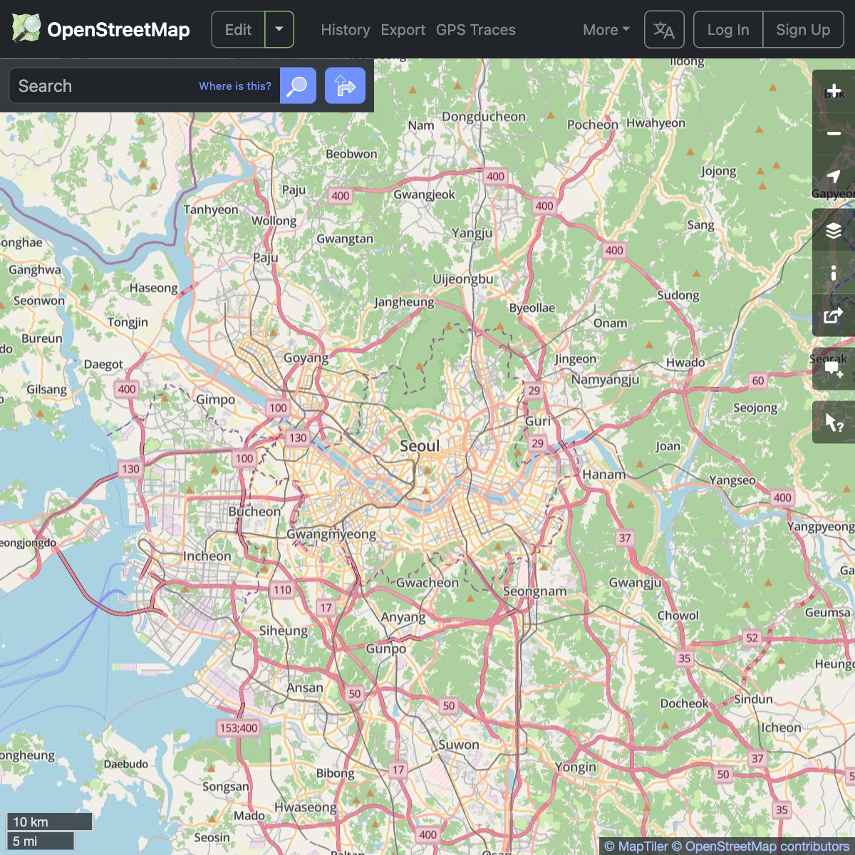
We're supporting the <a href="/openstreetmap/">OpenStreetMap</a> community by providing a new map layer for their website.
Thanks to #VectorTiles technology, you can now read map labels in your own language, no matter what part of the world you are looking at! maptiler.link/452oQ8W
#WebMaps #OpenStreetMap
Away Team Software (@away_team) 's Twitter Profile Photo

Check out the updated #WebVMT demos which showcase CSS support, map rotation & MapLibre integration. Special thanks to MapTiler for permission to include their map data in the London-Brighton demo webvmt.org/demos W3C (@[email protected]) Open Geospatial: OGC OpenStreetMap BBC Hampshire & Isle of Wight
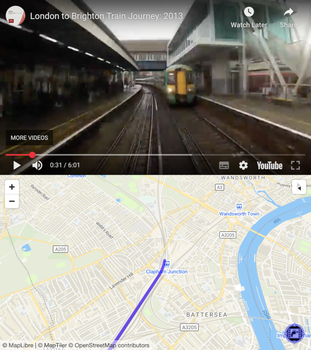
Check out the updated #WebVMT demos which showcase CSS support, map rotation &amp; <a href="/maplibre/">MapLibre</a> integration. Special thanks to <a href="/MapTiler/">MapTiler</a> for permission to include their map data in the London-Brighton demo webvmt.org/demos <a href="/w3c/">W3C (@w3c@w3c.social)</a> <a href="/opengeospatial/">Open Geospatial: OGC</a> <a href="/openstreetmap/">OpenStreetMap</a> <a href="/BBCSouthNews/">BBC Hampshire & Isle of Wight</a>
Bernie Sanders (@sensanders) 's Twitter Profile Photo

Tony Aguilar is a retired Special Forces Green Beret who won a Purple Heart for his service to this country. He took a contract helping to distribute aid in Gaza. There, he witnessed atrocities committed using American taxpayer dollars. Please watch this important video.

Md Mijanur Rahman🛰️🗺️🛰️ (@gisrsstudyhacks) 's Twitter Profile Photo

Mapping Urban Heat Islands with LST & UTFVI | Google Earth Engine & Landsat Tutorial link: youtube.com/live/p9HIfKJ4N… For more information about registration, visit our website: studyhacksgeospatial.com/google-earth-e… #UrbanHeatIsland #LST #UTFVI #GoogleEarthEngine #Landsat #RemoteSensing

Mapping Urban Heat Islands with LST &amp; UTFVI | Google Earth Engine &amp; Landsat
Tutorial link: youtube.com/live/p9HIfKJ4N…
For more information about registration, visit our website: studyhacksgeospatial.com/google-earth-e…
#UrbanHeatIsland #LST #UTFVI #GoogleEarthEngine #Landsat #RemoteSensing