Andrew Muehr (@andrewtornado11) 's Twitter Profile
Andrew Muehr

@andrewtornado11

🇺🇸 OU ‘25 Meteorology. I research supercells, tornadoes, and tropical cyclones. OWL Monday Night Shift Leader, Goldwater Scholar

ID: 1141176092293816320

calendar_today19-06-2019 02:49:17

1,1K Tweet

836 Takipçi

485 Takip Edilen

Oklahoma Weather Lab (@okwxlab) 's Twitter Profile Photo

Hello Sooners! Enjoy the relative “warmth” Monday before winter precipitation with record-setting and dangerous cold arrives Tuesday! The morning low will be 21, and the high will be 47 with increasing clouds throughout the day. Full forecast: owl.ou.edu

Andrew Muehr (@andrewtornado11) 's Twitter Profile Photo

Typical scene at our Monday Night OWL shift…many different conversations going on at once! What makes a tornado a tornado? Where are we seeing warm air advection? How cold is too cold? Grateful for this ever-growing community…almost 20 students showed up tonight! Oklahoma Weather Lab

Typical scene at our Monday Night OWL shift…many different conversations going on at once! What makes a tornado a tornado? Where are we seeing warm air advection? How cold is too cold? Grateful for this ever-growing community…almost 20 students showed up tonight! <a href="/OKwxlab/">Oklahoma Weather Lab</a>
Andrew Kenny (@andrew_kenny_wx) 's Twitter Profile Photo

So fortunate to have had the ability to work for the NWS. Thank you to everyone at SGF and beyond who helped me along the way. The photo below is of me with the first AFD I ever wrote on my own. I will cherish this experience forever.

So fortunate to have had the ability to work for the NWS. Thank you to everyone at SGF and beyond who helped me along the way. The photo below is of me with the first AFD I ever wrote on my own. I will cherish this experience forever.
Oklahoma Mesonet (@okmesonet) 's Twitter Profile Photo

The windiest day in Oklahoma history? No, just another Friday. Be prepared for blowing dust, damaging non-thunderstorm wind gusts of 60-70 mph with locally higher gusts, extreme fire danger, and lawn furniture from two counties over. #okwx #okmesonet

The windiest day in Oklahoma history? No, just another Friday. Be prepared for blowing dust, damaging non-thunderstorm wind gusts of 60-70 mph with locally higher gusts, extreme fire danger, and lawn furniture from two counties over. #okwx #okmesonet
Andrew Muehr (@andrewtornado11) 's Twitter Profile Photo

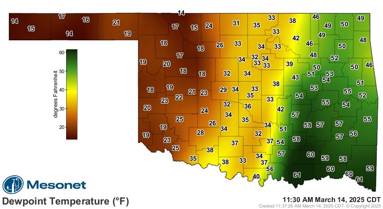
Interesting structure to the pacific front/dryline today. Looks like an intermediate zone of 30s dewpoints with a lot of dust but only moderately strong winds (and even a narrow strip of slightly higher moisture). The high end wind gusts are in the drier air in W OK.

Interesting structure to the pacific front/dryline today. Looks like an intermediate zone of 30s dewpoints with a lot of dust but only moderately strong winds (and even a narrow strip of slightly higher moisture). The high end wind gusts are in the drier air in W OK.
Sam Brandt (@sambrandt99) 's Twitter Profile Photo

From a pure synoptic perspective, today's dryline has a lot going for it w.r.t. convective initiation. It can be tough to get both strong convergence and long parcel residence times along the same dryline.

From a pure synoptic perspective, today's dryline has a lot going for it w.r.t. convective initiation. It can be tough to get both strong convergence and long parcel residence times along the same dryline.
Oklahoma Weather Lab (@okwxlab) 's Twitter Profile Photo

Let us take you to the OWL Lab! Please consider helping support us and all we do. Donate to owl at givesooner.org 🦉 #OUGivingDay

Andrew Muehr (@andrewtornado11) 's Twitter Profile Photo

Some shots of what might have been a brief tornado just south of Penfield, Illinois yesterday. First video was taken at 5:07-5:08 pm, last photo was at 5:11 pm CDT. In the first part of the video there appears to be a couple faint swirls at the ground. NWS Lincoln IL