Andrew Markowitz (@amarkowitzwx) 's Twitter Profile
Andrew Markowitz

@amarkowitzwx

AKA “Snowstradamus” | Energy Meteorologist. Views are my own | 2023 @AMS_BPSM Board Chair | @psumeteo ‘19 | Wilmington, DE ➡️ Annapolis, MD ➡️ Boston ➡️ Denver

ID: 2158073915

linkhttps://linktr.ee/andrewmarkowitz calendar_today29-10-2013 03:06:03

11,11K Tweet

7,7K Followers

2,2K Following

Brad Panovich (@wxbrad) 's Twitter Profile Photo

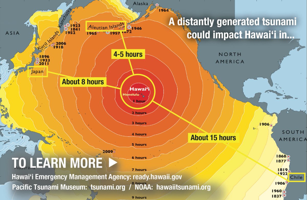
#Tsunmai travel time to Hawaii is generally around 5-6 hours from the location of tonight's quake, around 7:17 pm local time HST.

#Tsunmai travel time to Hawaii is generally around 5-6 hours from the location of tonight's quake, around 7:17 pm local time HST.
Sam Brandt (@sambrandt99) 's Twitter Profile Photo

A revision from magnitude 8.7 to 8.8 may feel small, but the logarithmic nature of the scale implies a roughly 40% difference in energy output

A revision from magnitude 8.7 to 8.8 may feel small, but the logarithmic nature of the scale implies a roughly 40% difference in energy output
Andrew Markowitz (@amarkowitzwx) 's Twitter Profile Photo

Similar to what we saw in 1965, this is likely to be a Pacific wide event. Megathrust quakes like this are notorious for producing tsunamis. A dangerous, life threatening situation is unfolding tonight in parts of Alaska, Hawaii, and other Pacific nations.

Andrew Markowitz (@amarkowitzwx) 's Twitter Profile Photo

As is the case with hurricane storm surge, all you need to do is go a little bit up or a little bit inland and you will be substantially safer.

Andrew Markowitz (@amarkowitzwx) 's Twitter Profile Photo

I am definitely concerned about potential for a significant flash flood event between VIRGINIA and CONNECTICUT including DC-NYC on 7/31. The atmosphere is ripe for training storms that could dump several inches of rain in a short period of time. Exact location of the band(s) TBD

I am definitely concerned about potential for a significant flash flood event between VIRGINIA and CONNECTICUT including DC-NYC on 7/31. 
The atmosphere is ripe for training storms that could dump several inches of rain in a short period of time. Exact location of the band(s) TBD
Andrew Markowitz (@amarkowitzwx) 's Twitter Profile Photo

Seems the dual banding signature picked up by hi-res models is working out well. FGEN banding to the north and a slow moving squall line to the south. In between is a subsidence “dead zone”. Unfortunately it seems the front was *just* north enough to get NYC in the banding.

Andrew Markowitz (@amarkowitzwx) 's Twitter Profile Photo

In case you were curious, the absolute minimum time you need to go from the A line train to the end of Gate A at Denver Airport is 21 minutes on the dot. I recently found out the hard way (yes I still made my flight)

Stormchasernick (@stormchasernick) 's Twitter Profile Photo

I’m concerned about mixing issues on the 18z GFS. I’ve highlighted the areas of concern in which an all snow scenario is very unlikely.

I’m concerned about mixing issues on the 18z GFS. 

I’ve highlighted the areas of concern in which an all snow scenario is very unlikely.
Andrew Markowitz (@amarkowitzwx) 's Twitter Profile Photo

I spent an extra $100 so I could wake up at 230 AM and fly back early, but it was all worth it for this boot. First of hopefully many pickleball chips in the books! David beat Goliath in an upset today.

I spent an extra $100 so I could wake up at 230 AM and fly back early, but it was all worth it for this boot. First of hopefully many pickleball chips in the books! David beat Goliath in an upset today.
Andrew Markowitz (@amarkowitzwx) 's Twitter Profile Photo

If the long range GFS was right, the I-95 big cities would average 200” of snow and several major hurricane landfalls per year. Some people’s timelines unironically look exactly like that for some reason.