Mel Griffin (@wxmel6) 's Twitter Profile
Mel Griffin

@wxmel6

@ABC NEWS METEOROLOGIST ⛈@ABCWorldNews | Tweets on @abcnewswx | FSU Alum, GO NOLES!

ID: 147814610

linkhttp://abcnews.go.com/Author/MELISSA_GRIFFIN calendar_today25-05-2010 03:35:19

4,4K Tweet

2,2K Followers

989 Following

Dan Peck (@danpeckwx) 's Twitter Profile Photo

UPDATE: Over a half foot of rain(6.24" so far) in New Orleans today! *Wettest April day for the city in nearly 20 years! 7.67" fell on 4/25/2004. Also 3rd wettest April day on record. Records go back to 1946. #flooding #lawx #NOLA Ginger Zee Rob Marciano Mel Griffin Max Golembo

ABC News Live (@abcnewslive) 's Twitter Profile Photo

A major storm is bringing tornadoes, heavy rain, flooding and damaging winds along the Gulf Coast while another severe storm is on the move in the Northeast area. Mel Griffin catches Kyra Phillips up.

NWS Mobile (@nwsmobile) 's Twitter Profile Photo

🌪️ STORM SURVEY UPDATE - Preliminary info from our team in the field indicates... 1 EF-1 tornado with winds up to 110mph in southern Escambia County, FL (Bellview area). 1 EF-1 tornado with winds up to 105mph in Santa Rosa County, FL (Pace area). More info released later today

Ginger Zee (@ginger_zee) 's Twitter Profile Photo

While April 2024 was remarkable (2nd highest tornado count since records began in 1950 for the month), May is climatologically the most prolific tornado month. I’ll have tonight’s threat on World News Tonight Mel Griffin
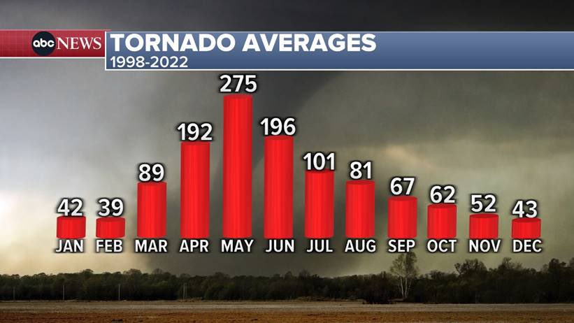
While April 2024 was remarkable (2nd highest tornado count since records began in 1950 for the month), May is climatologically the most prolific tornado month. I’ll have tonight’s threat on <a href="/ABCWorldNews/">World News Tonight</a> <a href="/WXmel6/">Mel Griffin</a>
NWS Des Moines (@nwsdesmoines) 's Twitter Profile Photo

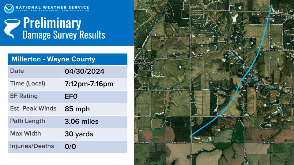
4/30 - Southern Iowa Tornado Update Damage was assessed in northern Wayne County (near Millerton) from Tuesday evening's storms. Damage to a machine shed, barn, and trees were consistent of a tornado with an EF0 rating, with estimated peak winds of 85 mph. #iawx

4/30 - Southern Iowa Tornado Update
Damage was assessed in northern Wayne County (near Millerton) from Tuesday evening's storms. Damage to a machine shed, barn, and trees were consistent of a tornado with an EF0 rating, with estimated peak winds of 85 mph. #iawx
NWS Topeka (@nwstopeka) 's Twitter Profile Photo

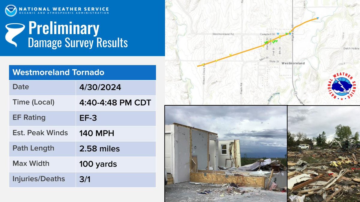
An EF3 Tornado struck Westmoreland Tuesday night with winds of 140 mph. This tornado injured 3 and killed one person. #kswx

An EF3 Tornado struck Westmoreland Tuesday night with winds of 140 mph.  This tornado injured 3 and killed one person. #kswx
NWS San Angelo (@nwssanangelo) 's Twitter Profile Photo

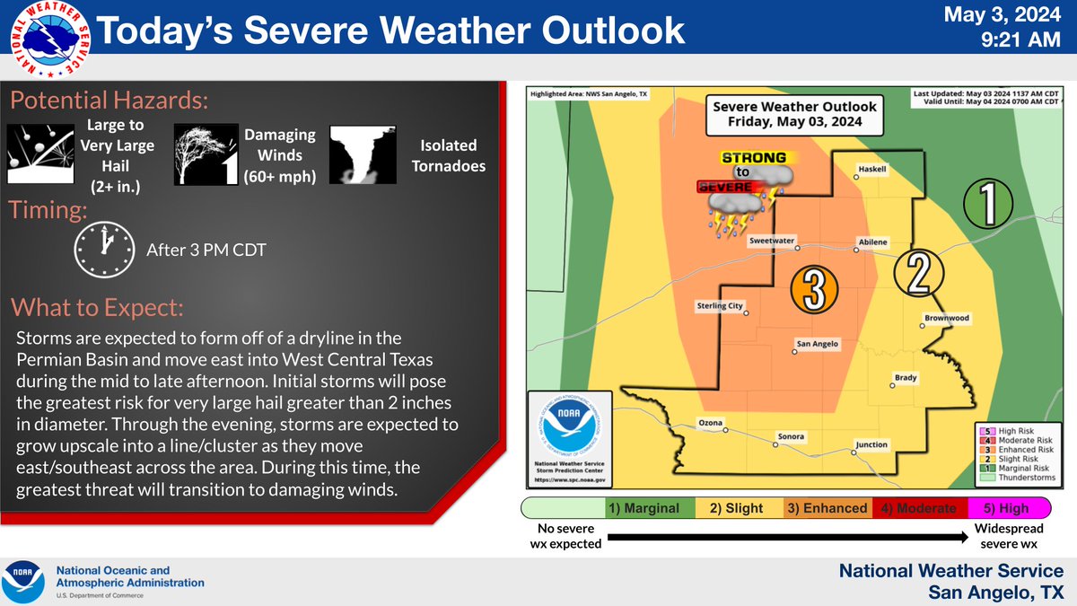
Latest outlook brings the enhanced severe potential farther west and includes Crockett county for the slight risk/enhanced severe. #txwx #sjtwx #abiwx

Latest outlook brings the enhanced severe potential farther west and includes Crockett county for the slight risk/enhanced severe.  #txwx #sjtwx #abiwx
Ginger Zee (@ginger_zee) 's Twitter Profile Photo

Timing is important for these severe storms as they’ll go well into the overnight from west to east! Nebraska, Kansas & Oklahoma 6 pm-12 am; Iowa, Missouri, Oklahoma & Arkansas 12 am-5 am — look at the Helpful maps from Mel Griffin
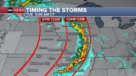
Timing is important for these severe storms as they’ll go well into the overnight from west to east! Nebraska, Kansas &amp; Oklahoma 6 pm-12 am; Iowa, Missouri, Oklahoma &amp; Arkansas 12 am-5 am — look at the Helpful maps from <a href="/WXmel6/">Mel Griffin</a>
Mel Griffin (@wxmel6) 's Twitter Profile Photo

Life threatening flash flooding possible this evening in parts of eastern TX and western LA; severe weather also a threat!

Mel Griffin (@wxmel6) 's Twitter Profile Photo

Houston is in cleanup mode after straight line winds up to 100mph caused widespread damage across the city....and more severe storms tonight along the Gulf Coast:

NWS Las Vegas (@nwsvegas) 's Twitter Profile Photo

High temperatures through the weekend will run 10-15 degrees above normal, with Thursday being the hottest day in the stretch. Numerous record high temperatures may be set.

High temperatures through the weekend will run 10-15 degrees above normal, with Thursday being the hottest day in the stretch. Numerous record high temperatures may be set.
NWS San Angelo (@nwssanangelo) 's Twitter Profile Photo

We've gone binary! We have made it to 111° as of 3:12 PM in San Angelo. Just last year this would've tied our all time record high for any day but after the scorcher we had late last June, now it's only the 3rd highest ever. If we had any cookies to bake, we would try 🌡️#txwx

NWS San Juan (@nwssanjuan) 's Twitter Profile Photo

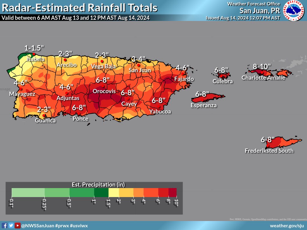
12 PM AST Aug 14: Radar-Estimated Rainfall Totals between 6 AM Aug 13 and 12 PM AST Aug 14, 2024. | Totales de lluvia estimados por radar entre las 6 AM del 13 de agosto y las 12 PM AST del 14 de agosto de 2024. #PRwx #USVIwx

12 PM AST Aug 14: Radar-Estimated Rainfall Totals between 6 AM Aug 13 and 12 PM AST Aug 14, 2024. | Totales de lluvia estimados por radar entre las 6 AM del 13 de agosto y las 12 PM AST del 14 de agosto de 2024. #PRwx #USVIwx
ABC News (@abc) 's Twitter Profile Photo

Hurricane Milton is barreling toward Florida, bringing ferocious rain, wind and rising waters. It's expected to bring a potentially record-breaking storm surge. ABC News meteorologist @wxmel6 explains what a storm surge is — and why it's so dangerous. trib.al/Y5LGJNc

NWS Weather Prediction Center (@nwswpc) 's Twitter Profile Photo

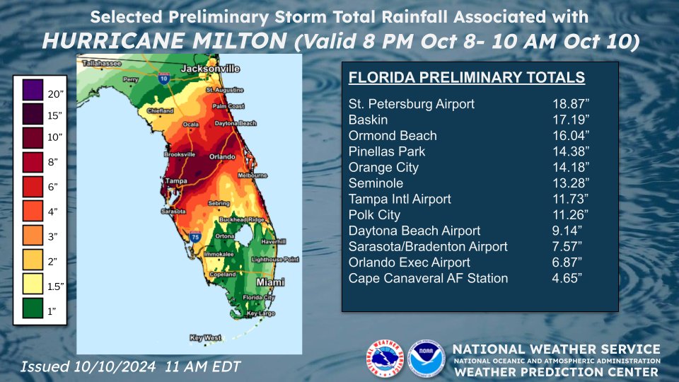
🌧️ Select rainfall totals associated with #Milton as of this morning. All rainfall reports should be considered preliminary. For a list of the highest wind and rainfall reports visit: wpc.ncep.noaa.gov/discussions/nf…

🌧️ Select rainfall totals associated with #Milton as of this morning. All rainfall reports should be considered preliminary.

For a list of the highest wind and rainfall reports visit: wpc.ncep.noaa.gov/discussions/nf…
NWS Albuquerque (@nwsalbuquerque) 's Twitter Profile Photo

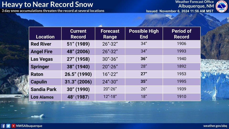
How heavy will the snow be? Let's look at some records and the forecast for the northeast, where we expect some of the heaviest snow. At least three all time records have a good chance of being broken. #nmwx

How heavy will the snow be? Let's look at some records and the forecast for the northeast, where we expect some of the heaviest snow.  At least three all time records have a good chance of being broken. #nmwx
NWS Boulder (@nwsboulder) 's Twitter Profile Photo

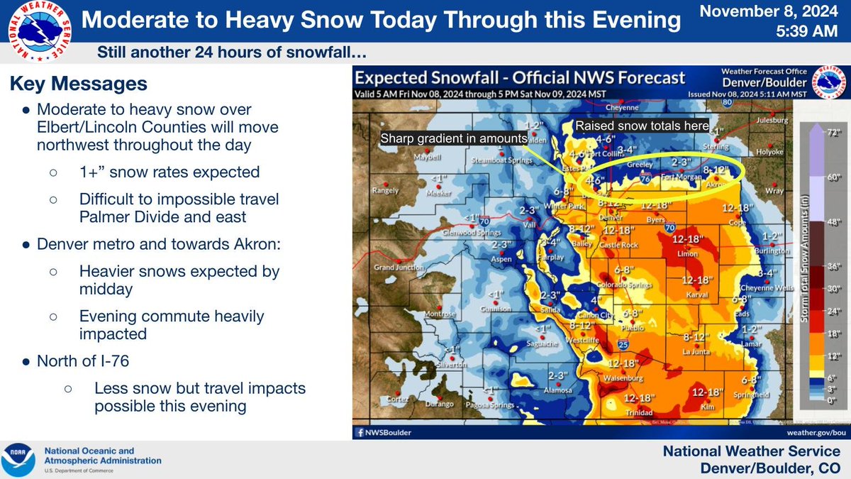
Continued heavy snow leading to extreme three-day totals across the Palmer Divide and Lincoln County. Difficult to impossible travel in those areas. PM commute impacted across metro Denver/Boulder. Check cotrip.org for the latest road conditions #cowx

Continued heavy snow leading to extreme three-day totals across the Palmer Divide and Lincoln County.  Difficult to impossible travel in those areas.  PM commute impacted across metro Denver/Boulder.  Check cotrip.org for the latest road conditions #cowx
NWS Los Angeles (@nwslosangeles) 's Twitter Profile Photo

HEADS UP!!! A LIFE-THREATENING, DESTRUCTIVE, Widespread Windstorm is expected Tue afternoon-Weds morning across much of Ventura/LA Co. Areas not typically windy will be impacted. See graphic for areas of greatest concern. Stay indoors, away from windows, expect poweroutages. #LA

HEADS UP!!! A LIFE-THREATENING, DESTRUCTIVE, Widespread Windstorm is expected Tue afternoon-Weds morning across much of Ventura/LA Co. Areas not typically windy will be impacted. See graphic for areas of greatest concern. Stay indoors, away from windows, expect poweroutages. #LA
Ginger Zee (@ginger_zee) 's Twitter Profile Photo

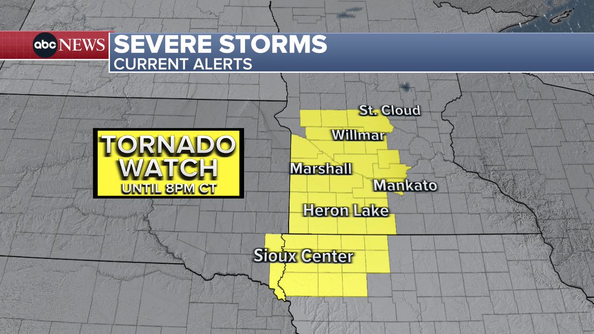
Monday 12:45 pm CDT Tornado Watch for parts of MN, IA, SD through 8PM CT.   A few tornadoes are likely with a couple intense tornadoes possible. widespread very large hail up to 3” in diameter. Damaging winds to 80mph are also possible. @wxmel6

Monday 12:45 pm CDT

Tornado Watch for parts of MN, IA, SD through 8PM CT.
 
A few tornadoes are likely with a couple intense tornadoes possible. widespread very large hail up to 3” in diameter. Damaging winds to 80mph are also possible. @wxmel6