NWS Paducah, KY(@NWSPaducah) 's Twitter Profile Photo

Showers and a few thunderstorms are expected to continue through this evening. It will be more on than off - but the kind of rain that will get you wet running to the car! Locally heavy rain and some briefly gusty winds are possible.

Showers and a few thunderstorms are expected to continue through this evening. It will be more on than off - but the kind of rain that will get you wet running to the car! Locally heavy rain and some briefly gusty winds are possible.
account_circle
NWS Paducah, KY(@NWSPaducah) 's Twitter Profile Photo

A Dense Fog Advisory has been issued for southern Illinois, southeast Missouri, and the Purchase Area of west Kentucky until 9 AM this morning. Areas of dense fog will reduce visibilities to a quarter mile or less.

A Dense Fog Advisory has  been issued for southern Illinois, southeast Missouri, and the Purchase Area of west Kentucky until 9 AM this morning. Areas of dense fog will reduce visibilities to a quarter mile or less.
account_circle
NWS Paducah, KY(@NWSPaducah) 's Twitter Profile Photo

Widespread showers and thunderstorms will push through the region today and exit the area overnight.
Localized heavy rainfall will be possible throughout the region. Above normal temperatures the next 7 days.

Widespread showers and thunderstorms will push through the region today and exit the area overnight.
Localized heavy rainfall will be possible throughout the region. Above normal temperatures the next 7 days.
account_circle
NWS Paducah, KY(@NWSPaducah) 's Twitter Profile Photo

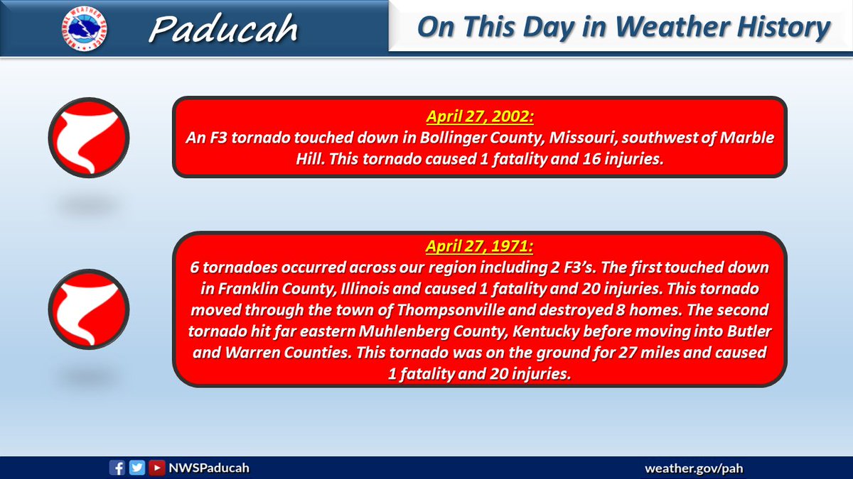
On this date in Weather History: An F3 tornado struck Hopkinsville, KY back on April 29, 1963. Meanwhile, way back in 1909 an F4 tornado hit southern Illinois.

On this date in Weather History: An F3 tornado struck Hopkinsville, KY back on April 29, 1963. Meanwhile, way back in 1909 an F4 tornado hit southern Illinois.
account_circle
NWS Paducah, KY(@NWSPaducah) 's Twitter Profile Photo

On this date in Weather History: Several tornado events occurred on April 30 in previous years, including an F4 that struck southern Illinois back in 1940. Meanwhile, the St. Francis River at Patterson, MO experienced their highest crest on record back on April 30, 2017.

On this date in Weather History: Several tornado events occurred on April 30 in previous years, including an F4 that struck southern Illinois back in 1940. Meanwhile, the St. Francis River at Patterson, MO experienced their highest crest on record back on April 30, 2017.
account_circle
NWS Paducah, KY(@NWSPaducah) 's Twitter Profile Photo

Happy Monday morning from NWS Paducah! Looks like we had a pretty good frost here with a morning low of 35 degrees. Did you have frost in your town? Let us know if you did. Have a great day!

Happy Monday morning from NWS Paducah! Looks like we had a pretty good frost here with a morning low of 35 degrees. Did you have frost in your town? Let us know if you did. Have a great day!
account_circle
Missouri State Emergency Management Agency(@MoSEMA_) 's Twitter Profile Photo

We appreciate the opportunity to meet and further strengthen our collaboration with National Weather Service forecast offices serving Missouri:
National Weather ServiceStLouis 's Kevin Deitsch
National Weather ServiceSpringfield's Steve Runnels,
National Weather ServiceKansasCity John Kurtz &
National Weather ServicePaducah's Christine Wielgos & Steve Eddy

We appreciate the opportunity to meet and further strengthen our collaboration with @NWS forecast offices serving Missouri: 
@NWSStLouis 's @KDeitsch_wx 
@NWSSpringfield's Steve Runnels, 
@NWSKansasCity John Kurtz & 
@NWSPaducah's Christine Wielgos & Steve Eddy
#WeServeMO
account_circle
NWS Paducah, KY(@NWSPaducah) 's Twitter Profile Photo

On this date in Weather History: Severe thunderstorms produced 8 tornadoes, including 3 F3’s, back on April 28, 2002.

On this date in Weather History: Severe thunderstorms produced 8 tornadoes, including 3 F3’s, back on April 28, 2002.
account_circle
NWS Quad Cities(@NWSQuadCities) 's Twitter Profile Photo

Yesterday we took a break from forecasting and instead shared and learned from each other in a seasonal-readiness training day. It was a rare time ALL of our staff were together. We are so proud of that!🙌

Thank you NWS Paducah, KY for handling our forecast yesterday! 🤝

Yesterday we took a break from forecasting and instead shared and learned from each other in a seasonal-readiness training day. It was a rare time ALL of our staff were together. We are so proud of that!🙌

Thank you @NWSPaducah for handling our forecast yesterday! 🤝 #IAwx #KYwx
account_circle
NWS Paducah, KY(@NWSPaducah) 's Twitter Profile Photo

It will be warm through the week, with some locations reaching the upper 80s for highs Wednesday and Thursday. Showers and thunderstorms will move east into southeast Missouri Thursday afternoon and then spread over the entire region Thursday night and Friday.

It will be warm through the week, with some locations reaching the upper 80s for highs Wednesday and Thursday. Showers and thunderstorms will move east into southeast Missouri Thursday afternoon and then spread over the entire region Thursday night and Friday.
account_circle
NWS Paducah, KY(@NWSPaducah) 's Twitter Profile Photo

Showers and thunderstorms move into Southeast Missouri late this evening, with the line progressing eastward through the night. A few storms in SEMO may be strong but severe weather potential will be on a declining trend before the line arrives. Locally heavy rain is possible.

Showers and thunderstorms move into Southeast Missouri late this evening, with the line progressing eastward through the night. A few storms in SEMO may be strong but severe weather potential will be on a declining trend before the line arrives. Locally heavy rain is possible.
account_circle
NWS Paducah, KY(@NWSPaducah) 's Twitter Profile Photo

On this date in Weather History: April 24 was an active day in previous years. Past events included strong tornadoes in 2002 and 1970, an intense macroburst in 2010 (weather.gov/media/pah/Top1…), and an extremely rare late season snowstorm in 1910 (weather.gov/pah/SnowApr24-…).

On this date in Weather History: April 24 was an active day in previous years. Past events included strong tornadoes in 2002 and 1970, an intense macroburst in 2010 (weather.gov/media/pah/Top1…), and an extremely rare late season snowstorm in 1910 (weather.gov/pah/SnowApr24-…).
account_circle
NWS Paducah, KY(@NWSPaducah) 's Twitter Profile Photo

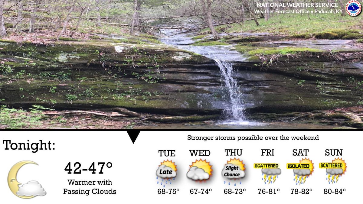
A weak cold front will bring the next chance of rain late Tuesday into Tuesday night. The pattern then turns unsettled and unseasonably warm Friday through the weekend with daily chances of storms.

A weak cold front will bring the next chance of rain late Tuesday into Tuesday night. The pattern then turns unsettled and unseasonably warm Friday through the weekend with daily chances of storms.
account_circle
NWS Paducah, KY(@NWSPaducah) 's Twitter Profile Photo

Rain chances accompany a cold front's passage tonight, and return again over the weekend. Seasonal spring-time temperatures will warm into the 80s and 60s by week's end.

Rain chances accompany a cold front's passage tonight, and return again over the weekend. Seasonal spring-time temperatures will warm into the 80s and 60s by week's end.
account_circle
NWS Paducah, KY(@NWSPaducah) 's Twitter Profile Photo

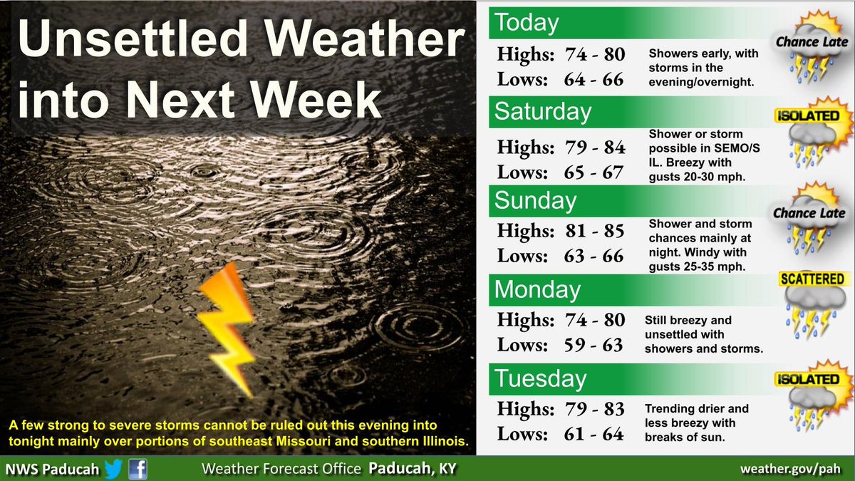
While the weather pattern will be unsettled through the weekend, the daylight hours on Saturday and Sunday look to be fairly dry and unseasonably warm. The greatest risk for rain holds off until Sunday night into Monday as a cold front slowly approaches.

While the weather pattern will be unsettled through the weekend, the daylight hours on Saturday and Sunday look to be fairly dry and unseasonably warm. The greatest risk for rain holds off until Sunday night into Monday as a cold front slowly approaches.
account_circle
NWS Paducah, KY(@NWSPaducah) 's Twitter Profile Photo

While scattered showers and thunderstorms will be possible tonight through the weekend, the majority of the daytime hours on Saturday and Sunday look dry. The highest chance for rain and heavier rainfall amounts looks to hold off until Sunday night and into Monday.

While scattered showers and thunderstorms will be possible tonight through the weekend, the majority of the daytime hours on Saturday and Sunday look dry. The highest chance for rain and heavier rainfall amounts looks to hold off until Sunday night and into Monday.
account_circle