NWS Quad Cities(@NWSQuadCities) 's Twitter Profileg
NWS Quad Cities

@NWSQuadCities

Official Twitter account for the National Weather Service Quad Cities. Details: https://t.co/N9WuG1YHsk

Also Facebook: https://t.co/lEeF3htB3C

ID:598764653

linkhttp://www.weather.gov/dvn calendar_today03-06-2012 23:55:35

25,9K Tweets

24,6K Followers

191 Following

NWS Quad Cities(@NWSQuadCities) 's Twitter Profile Photo

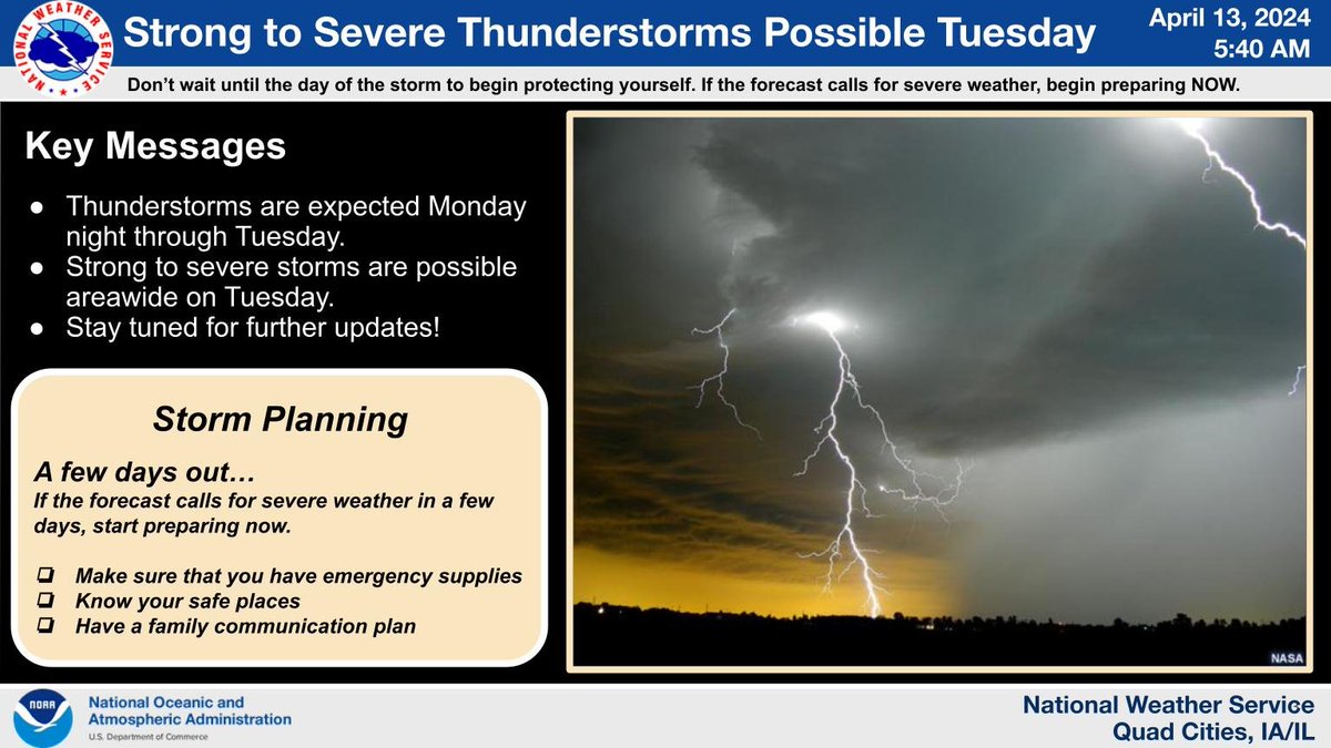
Thunderstorms are expected Monday night through Tuesday. Strong to severe storms remain possible across the entire area on Tuesday. Begin preparing now. Make sure you have emergency supplies. Know your safe places. Have a family communication plan. Stay tuned for updates!

Thunderstorms are expected Monday night through Tuesday. Strong to severe storms remain possible across the entire area on Tuesday. Begin preparing now. Make sure you have emergency supplies. Know your safe places. Have a family communication plan. Stay tuned for updates!
account_circle
NWS Quad Cities(@NWSQuadCities) 's Twitter Profile Photo

The Average Date of the Last Spring Freeze (32°) has arrived in the southern part of our area. By late this month, most of the area will have seen its Average Date of the Last Spring Freeze. As always, continue to monitor for freezing temperatures at weather.gov/dvn/FREEZE.

The Average Date of the Last Spring Freeze (32°) has arrived in the southern part of our area. By late this month, most of the area will have seen its Average Date of the Last Spring Freeze. As always, continue to monitor for freezing temperatures at weather.gov/dvn/FREEZE.
account_circle
NWS Quad Cities(@NWSQuadCities) 's Twitter Profile Photo

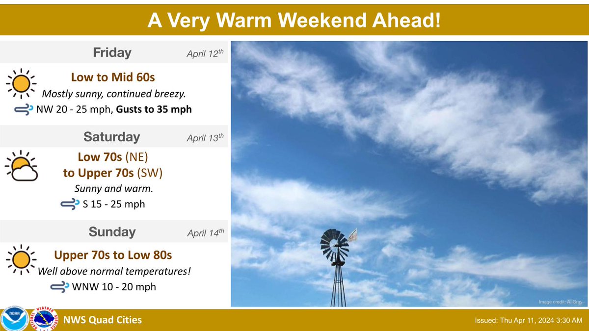
Plenty of sunshine and temperatures well above normal will be seen through Monday. Highs will be in the 70s to mid 80s, which is more typical for early to mid-June!

Plenty of sunshine and temperatures well above normal will be seen through Monday. Highs will be in the 70s to mid 80s, which is more typical for early to mid-June!
account_circle
NWS Quad Cities(@NWSQuadCities) 's Twitter Profile Photo

With the potential for much of the area to reach 80 degrees or warmer by Sunday, here is the climatology for the average date to first reach 80 degrees in the year. As it turns out, 80 degrees on Sunday April 14th won't be that far off of normal.

With the potential for much of the area to reach 80 degrees or warmer by Sunday, here is the climatology for the average date to first reach 80 degrees in the year. As it turns out, 80 degrees on Sunday April 14th won't be that far off of normal.
account_circle
NWS Quad Cities(@NWSQuadCities) 's Twitter Profile Photo

Thunderstorms are expected Monday Night through Tuesday. Strong to severe storms are possible areawide on Tuesday. Begin preparing now. Make sure you have emergency supplies. Know your safe places. Have a family communication plan. Stay tuned for further updates!

Thunderstorms are expected Monday Night through Tuesday. Strong to severe storms are possible areawide on Tuesday. Begin preparing now. Make sure you have emergency supplies. Know your safe places. Have a family communication plan. Stay tuned for further updates!
account_circle
NWS Quad Cities(@NWSQuadCities) 's Twitter Profile Photo

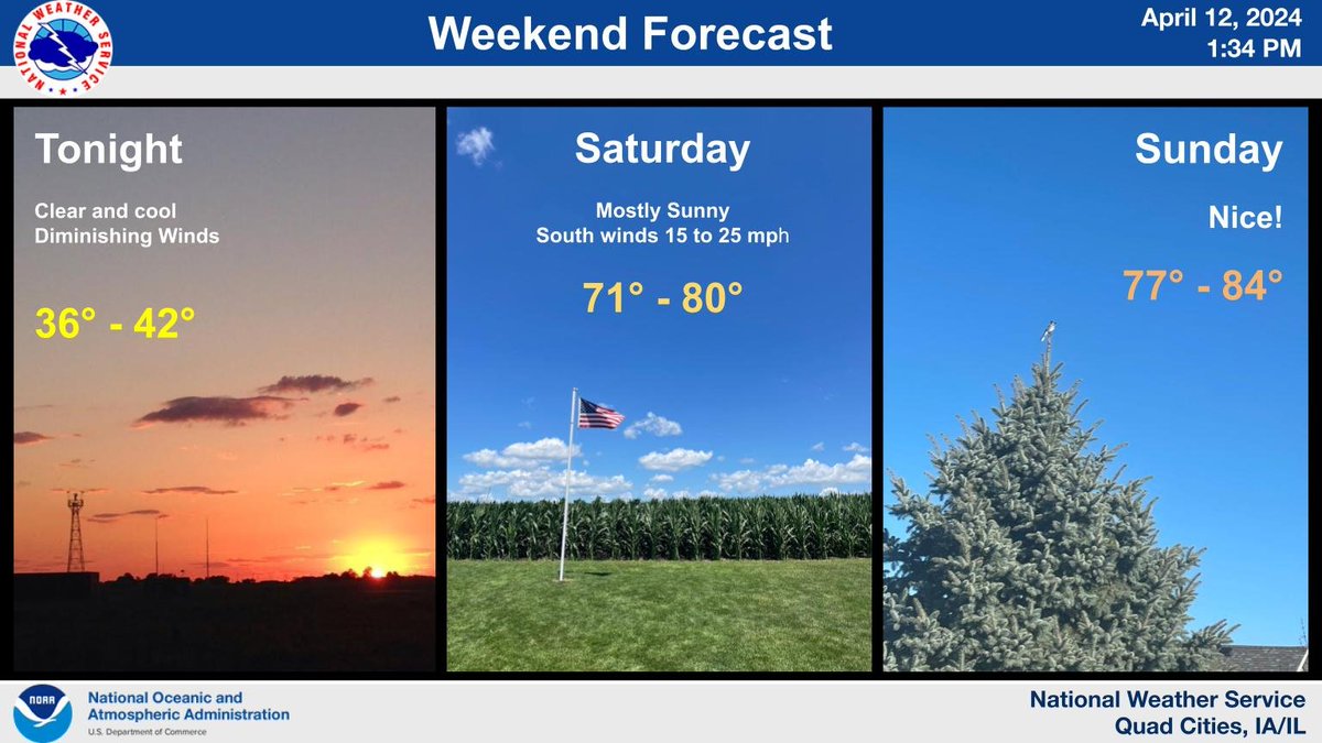
Sunny skies will prevail through Sunday. Today, winds will be from the northwest with occasional gusts up to 40 MPH! Highs will top out in the upper 50s to mid 60s. Warmer temperatures are expected over the weekend, with 70s on Saturday and mid 70s to lower 80s Sunday!

Sunny skies will prevail through Sunday. Today, winds will be from the northwest with occasional gusts up to 40 MPH! Highs will top out in the upper 50s to mid 60s. Warmer temperatures are expected over the weekend, with 70s on Saturday and mid 70s to lower 80s Sunday!
account_circle
NWS Quad Cities(@NWSQuadCities) 's Twitter Profile Photo

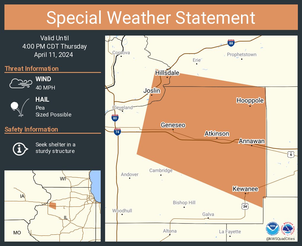
[530 pm] - showers and storms are slowly weakening as they move slowly southeast this evening. Stronger storm cores will be capable of producing lightning, small hail, wind gusts up to 40 MPH and funnel clouds.

[530 pm] - showers and storms are slowly weakening as they move slowly southeast this evening. Stronger storm cores will be capable of producing lightning, small hail, wind gusts up to 40 MPH and funnel clouds. #iawx #ilwx #mowx
account_circle
NWS Quad Cities(@NWSQuadCities) 's Twitter Profile Photo

[340pm] - We are monitoring showers and storms as they move slowly southeast this afternoon. Storms will be capable of producing lightning, wind gusts up to 40 MPH and funnel clouds.

[340pm] - We are monitoring showers and storms as they move slowly southeast this afternoon. Storms will be capable of producing lightning, wind gusts up to 40 MPH and funnel clouds. #iawx #ilwx #mowx
account_circle
NWS Quad Cities(@NWSQuadCities) 's Twitter Profile Photo

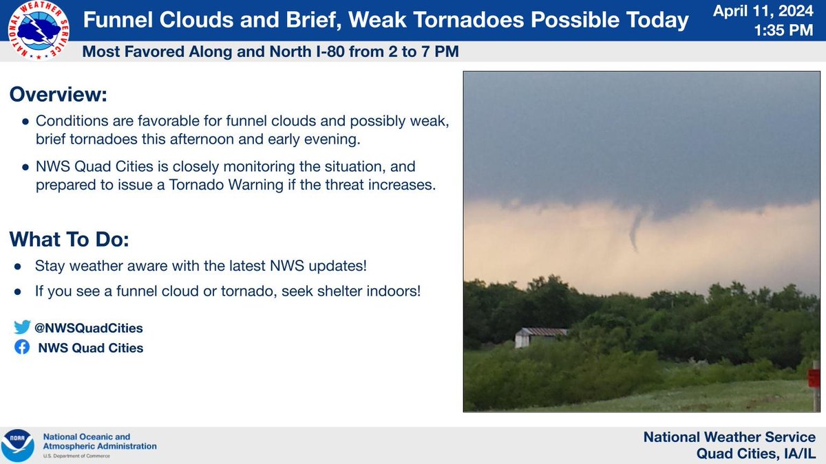
Conditions are favorable for funnel clouds and possibly weak, brief tornadoes this afternoon and early evening, especially along and north of I-80. NWS Quad Cities is closely monitoring the situation, and prepared to issue a Tornado Warning if the threat increases.

Conditions are favorable for funnel clouds and possibly weak, brief tornadoes this afternoon and early evening, especially along and north of I-80. NWS Quad Cities is closely monitoring the situation, and prepared to issue a Tornado Warning if the threat increases.
account_circle
NWS Quad Cities(@NWSQuadCities) 's Twitter Profile Photo

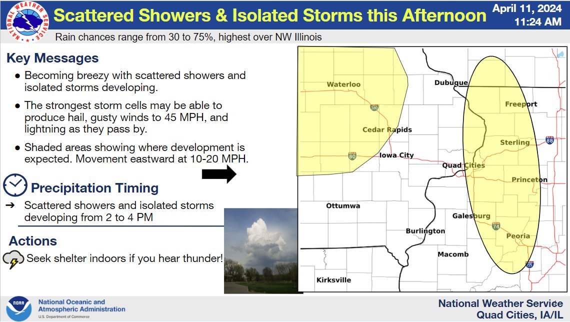
Scattered showers & T-storms developing this afternoon & evening. The stronger storms may be able to produce hail, lightning & gusty winds to 45 MPH. The highest coverage is expected across northwest IL, but another area of formation may be across northeast into east central IA.

Scattered showers & T-storms developing this afternoon & evening. The stronger storms may be able to produce hail, lightning & gusty winds to 45 MPH. The highest coverage is expected across northwest IL, but another area of formation may be across northeast into east central IA.
account_circle
NWS Quad Cities(@NWSQuadCities) 's Twitter Profile Photo

The latest drought update shows there was widespread 1 class improvement over eastern IA 🙴 far northwest 🙴 west IL from a week ago thanks to rounds of heavy rainfall. This while portions of northeast/east central IA still had lingering areas of extreme drought.

The latest drought update shows there was widespread 1 class improvement over eastern IA 🙴 far northwest 🙴 west IL from a week ago thanks to rounds of heavy rainfall. This while portions of northeast/east central IA still had lingering areas of extreme drought.
account_circle
NWS Quad Cities(@NWSQuadCities) 's Twitter Profile Photo

☀️🌡️A large upper level ridge will build into the Plains and Midwest late in the week, leading to well above normal temperatures. Highs are forecast to be near 20 degrees above normal by Sunday! Dry conditions are expected through this period.

☀️🌡️A large upper level ridge will build into the Plains and Midwest late in the week, leading to well above normal temperatures. Highs are forecast to be near 20 degrees above normal by Sunday! Dry conditions are expected through this period. #iawx #ilwx #mowx
account_circle
NWS Quad Cities(@NWSQuadCities) 's Twitter Profile Photo

🌧️ A trough digging into the Midwest and Great Lakes today will result in scattered showers and isolated storms, mainly during the afternoon and evening. The highest chances for rain are to the northeast of the Quad Cities.

🌧️ A trough digging into the Midwest and Great Lakes today will result in scattered showers and isolated storms, mainly during the afternoon and evening. The highest chances for rain are to the northeast of the Quad Cities. #iawx #ilwx #mowx
account_circle
NWS Quad Cities(@NWSQuadCities) 's Twitter Profile Photo

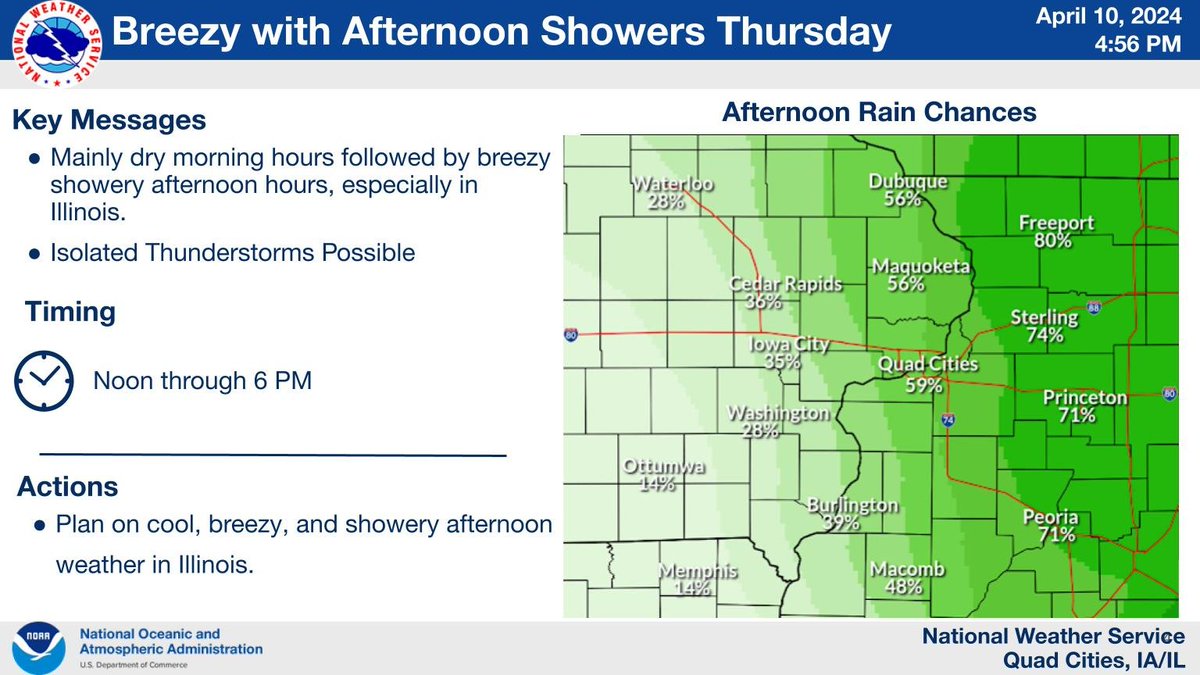
Following a mainly dry morning, a cool, breezy, and showery afternoon is expected, especially in Illinois Thursday. After highs in the lower 60s, temperatures in the afternoon will cool to the 50s, as showers begin to dot the area. A rumble of thunder is possible.

Following a mainly dry morning, a cool, breezy, and showery afternoon is expected, especially in Illinois Thursday. After highs in the lower 60s, temperatures in the afternoon will cool to the 50s, as showers begin to dot the area. A rumble of thunder is possible.
account_circle
NWS Quad Cities(@NWSQuadCities) 's Twitter Profile Photo

⛈️ Expect increasing clouds tonight with scattered showers and isolated storms on Thursday. The bulk of the steadier rain will stay east of the outlook area.

🌬️ Breezy NW winds are also expected Thursday through Friday.

⛈️ Expect increasing clouds tonight with scattered showers and isolated storms on Thursday. The bulk of the steadier rain will stay east of the outlook area. 🌬️ Breezy NW winds are also expected Thursday through Friday. #iawx #ilwx #mowx
account_circle