Glenn Hurricane Schwartz (@hurricanenbc10) 's Twitter Profile
Glenn Hurricane Schwartz

@hurricanenbc10

Retired Meteorologist... in Philly for 27 yrs....50 as a met!

Now a CCC...climate crisis communicator as extremes become more common & severe.

See website...

ID: 343523535

linkhttp://www.thehurricaneschwartz.com calendar_today27-07-2011 18:08:30

8,8K Tweet

18,18K Takipçi

371 Takip Edilen

Jeff Berardelli (@weatherprof) 's Twitter Profile Photo

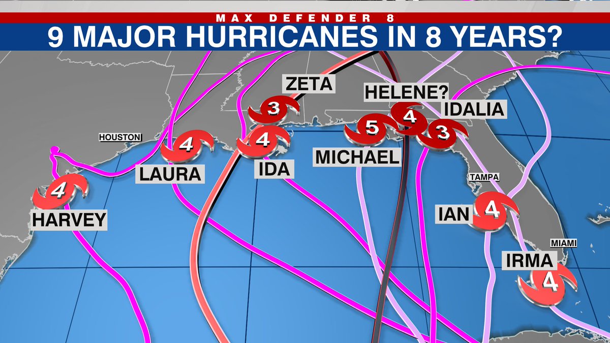
Update: now that NHC has increased the anticipated strength of #Helene to a Cat 4, I have updated this graphic. 9 major hurricane landfalls in the Gulf in just 8 years! We deserve a break!! WFLA NEWS

Update: now that NHC has increased the anticipated strength of #Helene to a Cat 4, I have updated this graphic. 9 major hurricane landfalls in the Gulf in just 8 years! We deserve a break!! <a href="/WFLA/">WFLA NEWS</a>
Jeff Berardelli (@weatherprof) 's Twitter Profile Photo

Waves and surge updated for #Helene Expecting some 50 ft waves in the Gulf and storm surge has now increased to a scary peak of up to 20 feet at the apex of the Big Bend. Nature Coast has also been increased by ~2 feet WFLA NEWS

Glenn Hurricane Schwartz (@hurricanenbc10) 's Twitter Profile Photo

The future of homeowner's insurance in Florida is grim. You think rates have skyrocketed? As they say: "You ain't seen nothin' yet"

Glenn Hurricane Schwartz (@hurricanenbc10) 's Twitter Profile Photo

Andrew....at one point late last week I saw a post that mentioned the AI version of the Euro showed suppressed...faster..and weaker solution than even Euro ensembles. Is that right? And what does that mean for the future?

Glenn Hurricane Schwartz (@hurricanenbc10) 's Twitter Profile Photo

Slightly? Check out the post-storm report on Jan 25 2000 surprise snowstorm. ONE missing upper-air ob led to forecasts of 1" lead to 10-20" from NC to NY. AI couldn't have caught it without the data.

Glenn Hurricane Schwartz (@hurricanenbc10) 's Twitter Profile Photo

Andrew...take a look at the Jan 25 2000 surprise snowstorm that changed a 1" forecast to a foot or more from NC to NYC. ONE upper air station was missing and led to the monumental bust. It could clearly happen again.

Glenn Hurricane Schwartz (@hurricanenbc10) 's Twitter Profile Photo

I can't remember a bust that big over such a wide area in my 50 years of forecasting. And the post-storm report specified the missing upper air ob as the key.