City of Dallas Office of Emergency Management(@DallasOEM) 's Twitter Profileg
City of Dallas Office of Emergency Management

@DallasOEM

Official Twitter for the City of Dallas Office of Emergency Management. Call 911 for emergencies and 311 for non-emergencies.

https://t.co/EooOfD03Q4

ID:18161602

linkhttp://dallasoem.com calendar_today16-12-2008 13:05:48

12,8K Tweets

21,6K Followers

408 Following

NWS Fort Worth(@NWSFortWorth) 's Twitter Profile Photo

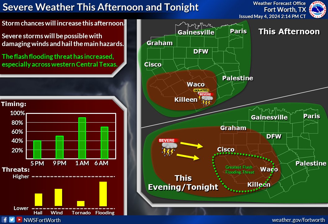
Storm chances will be on the rise later this afternoon and continue through the night. Severe storms will be possible with mainly a damaging wind and large hail threat.

Storm chances will be on the rise later this afternoon and continue through the night. Severe storms will be possible with mainly a damaging wind and large hail threat. #dfwwx #ctxwx
account_circle
NWS Fort Worth(@NWSFortWorth) 's Twitter Profile Photo

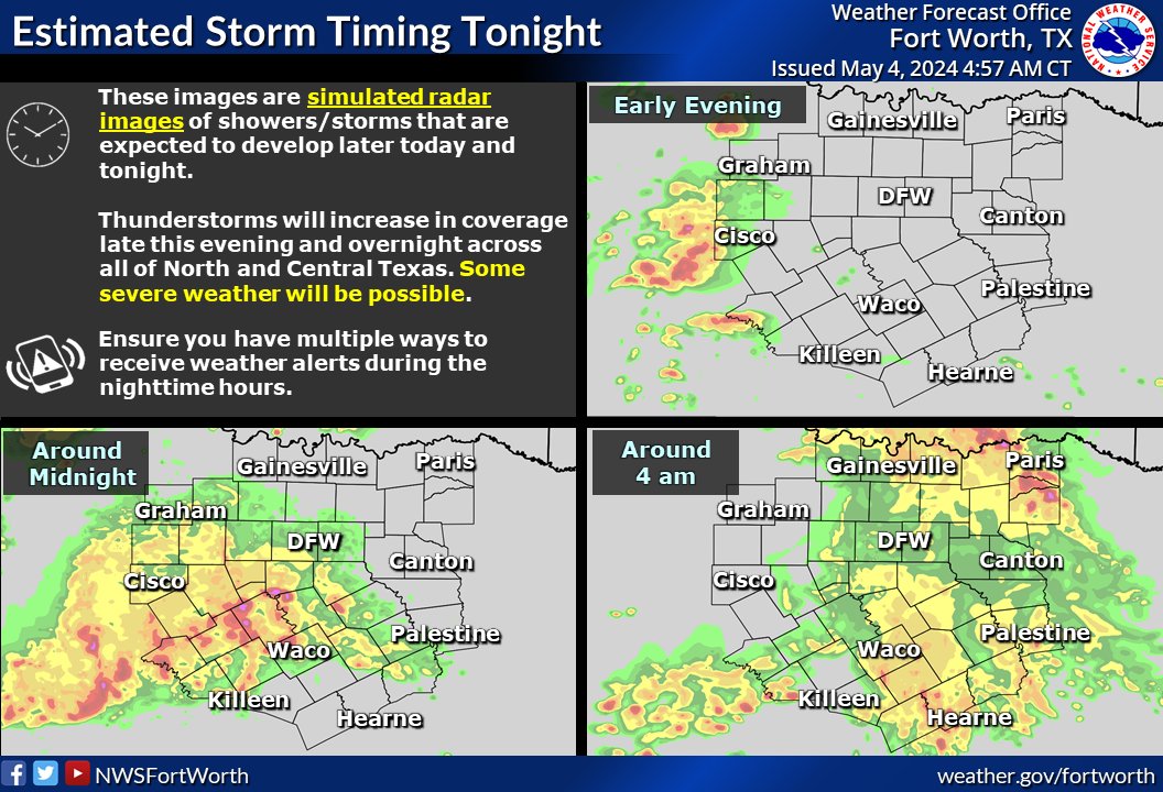
Thunderstorms will increase in coverage late this evening and overnight as a complex of thunderstorms moves across the region. Severe weather will be possible mainly west of I-35. The main threats will be heavy rain, hail, and damaging winds.

Thunderstorms will increase in coverage late this evening and overnight as a complex of thunderstorms moves across the region. Severe weather will be possible mainly west of I-35. The main threats will be heavy rain, hail, and damaging winds. #dfwwx #ctxwx
account_circle
Trinity River Corridor(@mytrinityriver) 's Twitter Profile Photo

Rain is in forecast this weekend. During inclement weather, avoid high water and flooded roadways. Turn Around. Don’t Drown. Visit weather.gov/safety/flood for flood safety tips. To report flooding concerns, Dallas residents may call 3-1-1

311 Dallas City of Dallas Office of Emergency Management City of Dallas

Rain is in forecast this weekend. During inclement weather, avoid high water and flooded roadways. Turn Around. Don’t Drown. Visit weather.gov/safety/flood for flood safety tips. To report flooding concerns, Dallas residents may call 3-1-1 @311Dallas @DallasOEM @CityOfDallas
account_circle
NWS Fort Worth(@NWSFortWorth) 's Twitter Profile Photo

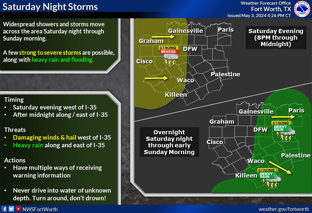
Widespread showers & thunderstorms will move through North and Central Texas Saturday night into early Sunday morning. Some storms may be severe across the western counties, while a threat for heavy rain & flooding will occur across the eastern counties.

Widespread showers & thunderstorms will move through North and Central Texas Saturday night into early Sunday morning. Some storms may be severe across the western counties, while a threat for heavy rain & flooding will occur across the eastern counties. #ctxwx #dfwwx #texomawx
account_circle
NWS Fort Worth(@NWSFortWorth) 's Twitter Profile Photo

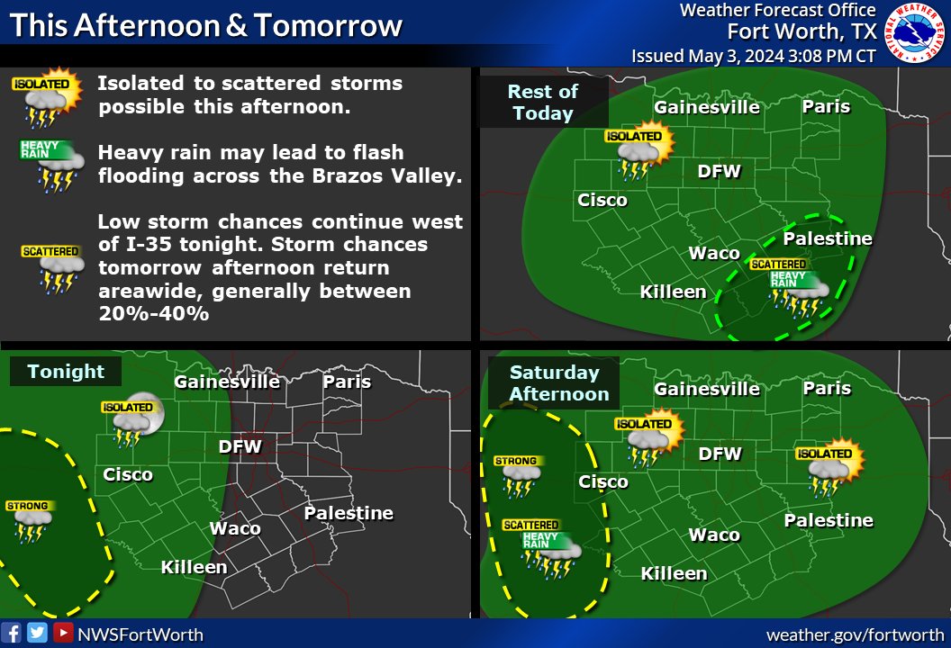
Heavy rain may lead to flash flooding this afternoon/evening across the Brazos Valley. Elsewhere, a few isolated storms will be possible through sunset. Low storm chances continue tonight and tomorrow. Coverage should remain isolated to scattered.

Heavy rain may lead to flash flooding this afternoon/evening across the Brazos Valley. Elsewhere, a few isolated storms will be possible through sunset. Low storm chances continue tonight and tomorrow. Coverage should remain isolated to scattered. #dfwwx #ctxwx
account_circle
NWS Fort Worth(@NWSFortWorth) 's Twitter Profile Photo

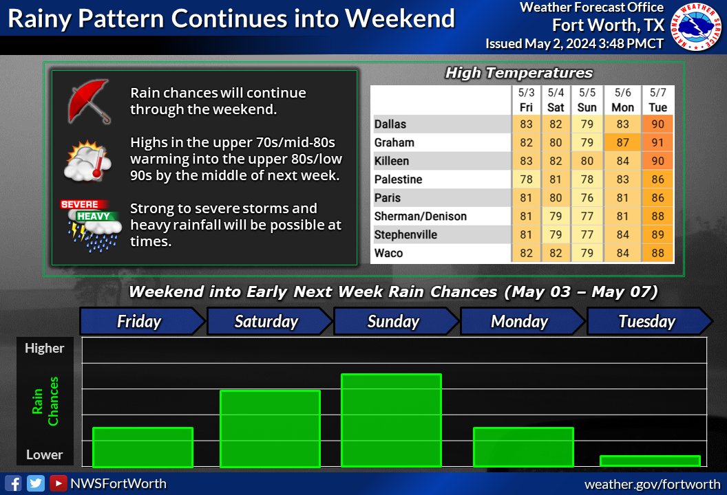
Periodic chances for rain are expected through the weekend. Severe storms and heavy rainfall will be possible at times. If you encounter flooded roadways, Turn Around, Don't Drown!

Periodic chances for rain are expected through the weekend. Severe storms and heavy rainfall will be possible at times. If you encounter flooded roadways, Turn Around, Don't Drown! #dfwwx #ctxwx
account_circle
NWS Fort Worth(@NWSFortWorth) 's Twitter Profile Photo

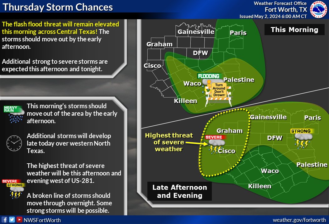
The flood threat will remain elevated this morning for parts of Central and East Texas. Never drive through flooded roads!

Additional storms are expected late in the day. The best chance of severe wx is over Wrn North and Central Texas late this afternoon.

The flood threat will remain elevated this morning for parts of Central and East Texas. Never drive through flooded roads! Additional storms are expected late in the day. The best chance of severe wx is over Wrn North and Central Texas late this afternoon. #txwx
account_circle
NWS Fort Worth(@NWSFortWorth) 's Twitter Profile Photo

Isolated storms are developing in Central TX this afternoon & will continue to develop into the evening. A few of these may become severe. The main round of storms arrives overnight, (~10 PM - 7 AM). The severe threat is highest west of I-35 with these storms.

Isolated storms are developing in Central TX this afternoon & will continue to develop into the evening. A few of these may become severe. The main round of storms arrives overnight, (~10 PM - 7 AM). The severe threat is highest west of I-35 with these storms. #dfwwx #ctxwx #txwx
account_circle
NWS Fort Worth(@NWSFortWorth) 's Twitter Profile Photo

In addition to the severe threat, there is an increased threat for flooding tonight into Thu morning, especially where heavy rain caused flooding issues over the past several days. Use extra caution at low water crossings & areas of poor drainage like urban & construction zones.

In addition to the severe threat, there is an increased threat for flooding tonight into Thu morning, especially where heavy rain caused flooding issues over the past several days. Use extra caution at low water crossings & areas of poor drainage like urban & construction zones.
account_circle
NWS Fort Worth(@NWSFortWorth) 's Twitter Profile Photo

Storm chances return later today into tonight. The threat for severe weather and flooding has increased, especially tonight. Here's the latest timing of the storms. ⚠️Make sure to have multiple ways to receive alerts before you go to bed tonight.

Storm chances return later today into tonight. The threat for severe weather and flooding has increased, especially tonight. Here's the latest timing of the storms. ⚠️Make sure to have multiple ways to receive alerts before you go to bed tonight. #dfwwx #ctxwx
account_circle
NWS Fort Worth(@NWSFortWorth) 's Twitter Profile Photo

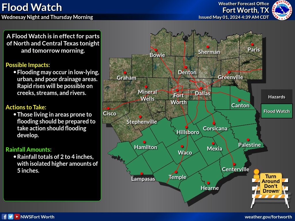
Thunderstorm coverage will increase Wednesday night into Thursday morning. Heavy rainfall, hail, and gusty winds are the main hazards. Soils are saturated across the region, so heavy rainfall could lead to new/renewed flooding concerns. As always, Turn Around, Don't Drown!

Thunderstorm coverage will increase Wednesday night into Thursday morning. Heavy rainfall, hail, and gusty winds are the main hazards. Soils are saturated across the region, so heavy rainfall could lead to new/renewed flooding concerns. As always, Turn Around, Don't Drown! #txwx
account_circle
NWS Fort Worth(@NWSFortWorth) 's Twitter Profile Photo

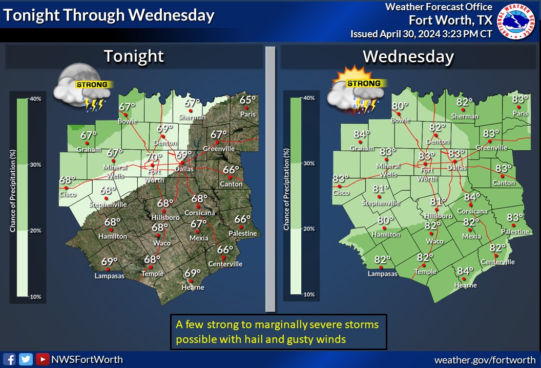
There is a low chance of storms across the northwest tonight. A few strong to marginally severe storms will be possible with hail and gusty winds. Storm chances will increase slightly region-wide on Wednesday. Highs Wednesday will be in the lower and middle 80s.

There is a low chance of storms across the northwest tonight. A few strong to marginally severe storms will be possible with hail and gusty winds. Storm chances will increase slightly region-wide on Wednesday. Highs Wednesday will be in the lower and middle 80s. #ctxwx #dfwwx
account_circle
NWS Fort Worth(@NWSFortWorth) 's Twitter Profile Photo

The late week and weekend pattern is still looking unsettled with daily storm chances. The best chance for storms will be late Wednesday/Thursday and late Saturday/Sunday. Heavy rain and a few strong/severe storms are possible Wednesday night/Thursday.

The late week and weekend pattern is still looking unsettled with daily storm chances. The best chance for storms will be late Wednesday/Thursday and late Saturday/Sunday. Heavy rain and a few strong/severe storms are possible Wednesday night/Thursday. #txwx
account_circle
NWS Fort Worth(@NWSFortWorth) 's Twitter Profile Photo

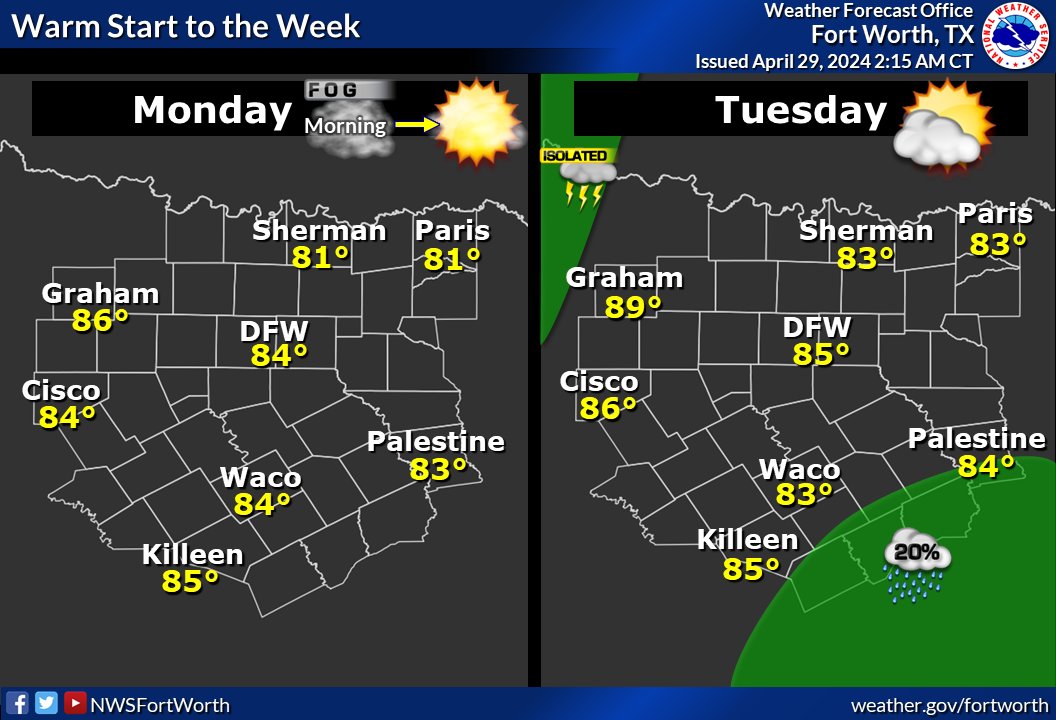
A short break in the active pattern is expected through Tuesday. Mostly clear skies are expected tonight with some patchy fog, although not as dense as Monday morning. Sunny skies and temps in the 80s are expected Tuesday with isolated storms west.

A short break in the active pattern is expected through Tuesday. Mostly clear skies are expected tonight with some patchy fog, although not as dense as Monday morning. Sunny skies and temps in the 80s are expected Tuesday with isolated storms west. #txwx
account_circle
NWS Fort Worth(@NWSFortWorth) 's Twitter Profile Photo

An active weather pattern will persist through the rest of the week. Thursday's rain chances will be the highest with a few strong/severe storms possible. Highs will cool into the 70s Friday and Saturday before bouncing back up Sunday.

An active weather pattern will persist through the rest of the week. Thursday's rain chances will be the highest with a few strong/severe storms possible. Highs will cool into the 70s Friday and Saturday before bouncing back up Sunday.
account_circle
NWS Fort Worth(@NWSFortWorth) 's Twitter Profile Photo

Patchy dense fog is expected across the majority of the region this morning. The fog will clear in the mid to late morning with sunny skies expected this afternoon. Another warm day is forecast Tuesday. There is a low chance of isolated showers across the southeast.

Patchy dense fog is expected across the majority of the region this morning. The fog will clear in the mid to late morning with sunny skies expected this afternoon. Another warm day is forecast Tuesday. There is a low chance of isolated showers across the southeast. #dfwwx #ctxwx
account_circle