Craig Ceecee, Ph.D.(@CC_StormWatch) 's Twitter Profileg
Craig Ceecee, Ph.D.

@CC_StormWatch

Meteorologist (from @msstate x2) focused on tornado protection and owner of Find Your Tornado Shelter LLC. @nwas and @ametsoc member. #STEM advocate. Mark 9:23.

ID:855153350672822272

linkhttp://findyourtornadoshelter.com calendar_today20-04-2017 20:17:01

74,4K Tweets

19,3K Followers

18,7K Following

Craig Ceecee, Ph.D.(@CC_StormWatch) 's Twitter Profile Photo

A watch is also in effect until 7 am for parts of North and Central Texas, including the Metroplex. Similarly, some embedded cells in the squall line could produce a few tornadoes overnight. An isolated supercell could also develop ahead of the line. wx

A #tornado watch is also in effect until 7 am for parts of North and Central Texas, including the #DFW Metroplex. Similarly, some embedded cells in the squall line could produce a few tornadoes overnight. An isolated supercell could also develop ahead of the line. #TXwx #DFWwx
account_circle
Craig Ceecee, Ph.D.(@CC_StormWatch) 's Twitter Profile Photo

A watch is in effect until 7 am for NW Arkansas and SE Oklahoma. The squall line is slowly moving east and with it could be a few embedded tornadoes. An isolated storm could also develop ahead of it overnight.

A #tornado watch is in effect until 7 am for NW Arkansas and SE Oklahoma. The squall line is slowly moving east and with it could be a few embedded tornadoes. An isolated storm could also develop ahead of it overnight. #OKwx #ARwx
account_circle
Craig Ceecee, Ph.D.(@CC_StormWatch) 's Twitter Profile Photo

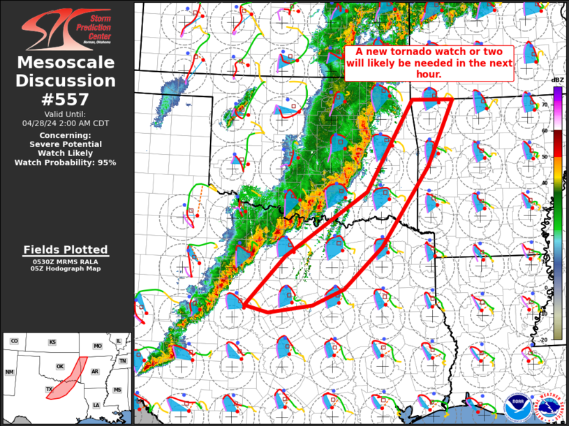
A new watch is coming soon for NW Arkansas, far eastern Oklahoma and North Texas, including the Metroplex. The squall line will continue to move east with embedded tornadoes likely overnight. A few supercells may also pop up ahead of the line.

A new #tornado watch is coming soon for NW Arkansas, far eastern Oklahoma and North Texas, including the Metroplex. The squall line will continue to move east with embedded tornadoes likely overnight. A few supercells may also pop up ahead of the line. #ARwx #OKwx #TXwx #DFWwx
account_circle
Craig Ceecee, Ph.D.(@CC_StormWatch) 's Twitter Profile Photo

This is a confirmed on the ground according to emergency management. It’s northeast of Morris and moving towards Haskell and Taft. Wake up anyone in the path!

This is a confirmed #tornado on the ground according to emergency management. It’s northeast of Morris and moving towards Haskell and Taft. Wake up anyone in the path! #OKwx
account_circle
Craig Ceecee, Ph.D.(@CC_StormWatch) 's Twitter Profile Photo

First an intense . Now rainfall rates of 3 to 5 inches per hour and major flash flooding likely. Sulphur can't catch a break. This will make it even harder for search and rescue.

First an intense #tornado. Now rainfall rates of 3 to 5 inches per hour and major flash flooding likely. Sulphur can't catch a break. This will make it even harder for search and rescue. #OKwx #flashflood
account_circle
Craig Ceecee, Ph.D.(@CC_StormWatch) 's Twitter Profile Photo

A new watch is in place for SW Missouri and extreme SE Kansas through 7 am. A few tornadoes remain likely overnight (a couple strong??) into the early morning both from embedded circulations in the squall line and any supercells ahead of it.

A new #tornado watch is in place for SW Missouri and extreme SE Kansas through 7 am. A few tornadoes remain likely overnight (a couple strong??) into the early morning both from embedded circulations in the squall line and any supercells ahead of it. #KSwx #MOwx
account_circle
Craig Ceecee, Ph.D.(@CC_StormWatch) 's Twitter Profile Photo

The threat should continue past midnight across eastern Oklahoma. The greatest concern is in the US 75 corridor - strong to violent tornadoes could continue with any supercells, and embedded tornadoes also likely in the squall line.

The #tornado threat should continue past midnight across eastern Oklahoma. The greatest concern is in the US 75 corridor - strong to violent tornadoes could continue with any supercells, and embedded tornadoes also likely in the squall line. #OKwx
account_circle
Craig Ceecee, Ph.D.(@CC_StormWatch) 's Twitter Profile Photo

As there are multiple storms moving through the same area, we can't forget about the threat. Flash flooding is likely in the same areas being hit hard by tornadoes, which makes it especially challenging for rescue operations. Not good.

account_circle
Craig Ceecee, Ph.D.(@CC_StormWatch) 's Twitter Profile Photo

If storms build into SE Oklahoma, there are several shelters there. Note there are quite a concentration near Atoka - those were built first after the 2011 tornadoes there, and @Reba helped out in the funding for them.

If storms build into SE Oklahoma, there are several #tornado shelters there. Note there are quite a concentration near Atoka - those were built first after the 2011 tornadoes there, and @Reba helped out in the funding for them. #OKwx
account_circle
Craig Ceecee, Ph.D.(@CC_StormWatch) 's Twitter Profile Photo

You have to give professional chasers credit. Quite a few of them have abandoned their storm chases after seeing towns get hit hard by tornadoes to join the search and rescue. That could be saving lives right now. We are likely seeing lives at least change forever tonight.

account_circle
Craig Ceecee, Ph.D.(@CC_StormWatch) 's Twitter Profile Photo

I hope this reached out to quite a few people. It's too late now to travel, but the additional time probably helped.

account_circle
Craig Ceecee, Ph.D.(@CC_StormWatch) 's Twitter Profile Photo

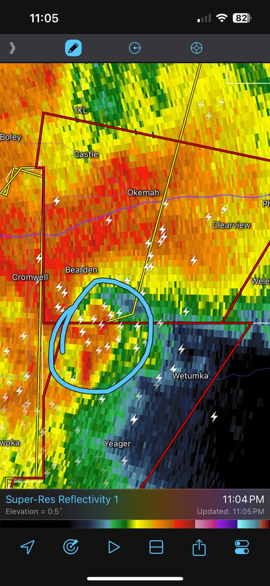
Bearden and Okemah, you need to be in shelter now. This has been an extremely strong and is still on the ground. Very dangerous situation ongoing. Get as far inside as you can and helmets on. Underground if possible. Abandon mobile homes and weaker structures.

Bearden and Okemah, you need to be in shelter now. This has been an extremely strong #tornado and is still on the ground. Very dangerous situation ongoing. Get as far inside as you can and helmets on. Underground if possible. Abandon mobile homes and weaker structures. #OKwx
account_circle
Aaron Coffey(@ACWxMan83) 's Twitter Profile Photo

REQUESTING ALL LOCAL EMERGENCY ASSISTANCE TO SULPHUR, OKLAHOMA and DOLBERG, OKLAHOMA. SULPHUR OKLAHOMA has taken a DIRECT HIT from a tornado and a life-threatening situation has developed. Remember to steer clear of downed power lines if at all possible!!

account_circle
Craig Ceecee, Ph.D.(@CC_StormWatch) 's Twitter Profile Photo

For those driving on I-40, the shelter at Okemah High School is nearby for you. Get off at Exit 221, go north and turn right at Date St. where the Sonic is. It's a good option that is right there. A violent tornado is coming in.

For those driving on I-40, the #tornado shelter at Okemah High School is nearby for you. Get off at Exit 221, go north and turn right at Date St. where the Sonic is. It's a good option that is right there. A violent tornado is coming in. #OKwx
account_circle
Craig Ceecee, Ph.D.(@CC_StormWatch) 's Twitter Profile Photo

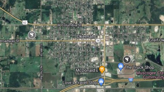
There are two shelters in Okemah, both at schools. You have less than 20 minutes to get there. If you have time, you should go to them - this is an intense tornado ongoing.

There are two #tornado shelters in Okemah, both at schools. You have less than 20 minutes to get there. If you have time, you should go to them - this is an intense tornado ongoing. #OKwx
account_circle
Craig Ceecee, Ph.D.(@CC_StormWatch) 's Twitter Profile Photo

I hope some of the messages I sent today got to people, especially in Oklahoma and Kansas, and saved lives. Property can be replaced but lives cannot. That is why I have the shelter map and project.

account_circle