Angie Lassman (@angielassman) 's Twitter Profile
Angie Lassman

@angielassman

@ametsoc Certified Broadcast Meteorologist at @NBC 🦚 insta: angielassman

ID: 2545034534

linkhttp://www.angielassman.com calendar_today04-06-2014 02:25:15

17,17K Tweet

8,8K Takipçi

2,2K Takip Edilen

Bryan Bennett (@weatherbryan) 's Twitter Profile Photo

(UPDATE: THU 1PM) ANTICIPATING RECORD SURGE TONIGHT: Bottom Line: The peak surge flooding in the Tampa Bay Area is going to rise between 4 & 6 feet higher than it is right now at 1pm. You can check the graphic, below, to see how much higher the water will get in your area.

(UPDATE: THU 1PM) ANTICIPATING RECORD SURGE TONIGHT:
Bottom Line: The peak surge flooding in the Tampa Bay Area is going to rise between 4 & 6 feet higher than it is right now at 1pm.  You can check the graphic, below, to see how much higher the water will get in your area.
Greg Diamond (@gdimeweather) 's Twitter Profile Photo

A chilling message. Over 10" of rain has already fallen from the "PRE" event in the mountains of western North Carolina and Helene is still hundreds of miles away. By Saturday, some spots may see 30, yes 30 inches of rain in two days

Jeff Berardelli (@weatherprof) 's Twitter Profile Photo

Once again, NOAA has raised the predicted water levels approx 1 ft. Here are the new forecasts vs records. Remember forecasts have an uncertainty of +- 2 ft. Stay safe everyone!! WFLA NEWS

Once again, NOAA has raised the predicted water levels approx 1 ft. Here are the new forecasts vs records. Remember forecasts have an uncertainty of +- 2 ft.
Stay safe everyone!! <a href="/WFLA/">WFLA NEWS</a>
𝘑𝘢𝘮𝘦𝘴 𝘈𝘺𝘥𝘦𝘭𝘰𝘵𝘵 📡🌪️🤓🍷🏴‍☠️ (@jamesaydelott) 's Twitter Profile Photo

The initial track forecast on Hurricane #Helene from the forecasters at National Hurricane Center was less than 40 miles off the actual landfall point -- Three and a half days ahead of landfall. Outstanding work by the best hurricane forecasters in the business. James Spann

The initial track forecast on Hurricane #Helene from the forecasters at <a href="/NHC_Atlantic/">National Hurricane Center</a> was less than 40 miles off the actual landfall point -- Three and a half days ahead of landfall.
Outstanding work by the best hurricane forecasters in the business.
<a href="/spann/">James Spann</a>
Jim Cantore (@jimcantore) 's Twitter Profile Photo

Knowing what’s about to happen or what could happen, then seeing it unfold into heartache and devastation is the hardest part of our job.

John Morales (@johnmoralestv) 's Twitter Profile Photo

I debated whether to share this. I did apologize on the air. But I invite you to read my introspection on Bulletin of the Atomic Scientists of how extreme weather 📈 driven by global warming has changed me. Frankly, YOU should be shaken too, and demand #ClimateActionNow. thebulletin.org/2024/09/hurric…

Tomer Burg (@burgwx) 's Twitter Profile Photo

Hurricane Milton's intensification rate is among the fastest in the satellite era records (1980-present) for a 24-hour window (80kt/24hr), and tied for the fastest for a 42, 48 and 54 hour window:

Hurricane Milton's intensification rate is among the fastest in the satellite era records (1980-present) for a 24-hour window (80kt/24hr), and tied for the fastest for a 42, 48 and 54 hour window:
Matthew Dominick (@dominickmatthew) 's Twitter Profile Photo

We flew over Hurricane Milton about 90 minutes ago. Here is the view out the Dragon Endeavour window. Expect lots of images from this window as this is where I’m sleeping while we wait to undock and return to Earth. Timelapse coming in a separate post. 1/6400 sec, f8, ISO 500

We flew over Hurricane Milton about 90 minutes ago. Here is the view out the Dragon Endeavour window. Expect lots of images from this window as this is where I’m sleeping while we wait to undock and return to Earth. 

Timelapse coming in a separate post. 

1/6400 sec, f8, ISO 500
Dylan Federico (@dylanfedericowx) 's Twitter Profile Photo

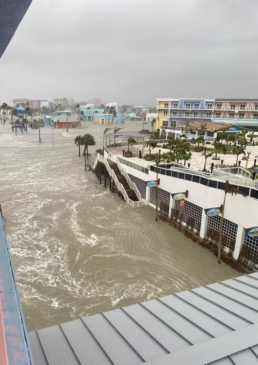
MAJOR STORM SURGE moving into Fort Myers Beach. This is at Margaritaville facing north towards Times Square. 📸 Beach Talk Radio #MILTON #flwx

MAJOR STORM SURGE moving into Fort Myers Beach.

This is at Margaritaville facing north towards Times Square. 

📸 Beach Talk Radio

#MILTON #flwx
Matthew Cappucci (@matthewcappucci) 's Twitter Profile Photo

THIS IS INSANE! St. Petersburg has reported 5.09 inches of rain in ONE HOUR and 9.04 inches in3 hours. That’s more rare than a thousand year rain event! Thresholds for 1,000-year rain there: 5.56”/1 hour 7.16”/2 hours 8.50”/3 hours MyRadar Weather

THIS IS INSANE! St. Petersburg has reported 5.09 inches of rain in ONE HOUR and 9.04 inches in3 hours.

That’s more rare than a thousand year rain event!

Thresholds for 1,000-year rain there:
5.56”/1 hour
7.16”/2 hours 
8.50”/3 hours <a href="/MyRadarWX/">MyRadar Weather</a>
Kathryn Prociv (@kathrynprociv) 's Twitter Profile Photo

#Hurricane #Milton produced 35+ preliminary #tornado reports and 126 #tornado warnings. Here are your Top 5 most-prolific tornado-producing tropical cyclones. #Beryl already cracked the Top 5 earlier this year. Hurricane Ivan 2004 (118 tornadoes) Hurricane Beulah 1967 (115

#Hurricane #Milton produced 35+ preliminary #tornado reports and 126 #tornado warnings. Here are your Top 5 most-prolific tornado-producing tropical cyclones. #Beryl already cracked the Top 5 earlier this year. 

Hurricane Ivan 2004 (118 tornadoes)
Hurricane Beulah 1967 (115
TODAY (@todayshow) 's Twitter Profile Photo

The Macy's Thanksgiving Day Parade is only four weeks away and preparation for the big event is already underway. Angie Lassman is at MetLife Stadium with more.

Bill Karins 💧 (@billkarins) 's Twitter Profile Photo

For just the 2nd time in 156 years, Boston has reached 80 degrees in November. The all-time November high temperature record stands at 83° in 1950. Dozens of other cities blowing away daily record highs on the East Coast.

For just the 2nd time in 156 years, Boston has reached 80 degrees in November. The all-time November high temperature record stands at 83° in 1950. Dozens of other cities blowing away daily record highs on the East Coast.
TODAY (@todayshow) 's Twitter Profile Photo

Today is a critical day for firefighters in Los Angeles with those strong, gusty Santa Ana winds back in the forecast. Angie Lassman has more for #SundayTODAY. today.com/video/dangerou…

TODAY (@todayshow) 's Twitter Profile Photo

With forecasts of a busy hurricane season ahead, Angie Lassman has our #SundayFocus on how federal cuts to the National Weather Service will hurt their ability to forecast deadly storms. #SundayTODAY today.com/video/hurrican…

John Morales (@johnmoralestv) 's Twitter Profile Photo

Good friend Angie Lassman with the latest on the cuts at NOAA & NWS on this morning’s NBC TODAY. After my brief cameo, the U.S. Secretary of Commerce states that the National Weather Service is “at full capacity” despite staff reductions of 600. today.com/video/hurrican…