Diana LaFleur (@zacsquiggles) 's Twitter Profile
Diana LaFleur

@zacsquiggles

I am a children's pastor, nature photographer, avid birdwatcher, and a free lance humor columnist and owned by 4 parrots. NO PORN! I WILL BLOCK YOU!

ID: 2243880164

calendar_today13-12-2013 13:02:40

31,31K Tweet

3,3K Takipçi

4,4K Takip Edilen

NWS Green Bay (@nwsgreenbay) 's Twitter Profile Photo

Much of today will be dry until later this aftn when snow arrives in central & north-central WI. Periods of snow continues thru early Mon. By early Mon, forecast snow totals: 4"-8". A narrow band to cause locally higher amounts, but there is uncertainty with this feature. #wiwx

Much of today will be dry until later this aftn when snow arrives in central & north-central WI. Periods of snow continues thru early Mon. By early Mon, forecast snow totals: 4"-8". A narrow band to cause locally higher amounts, but there is uncertainty with this feature. #wiwx
NWS Green Bay (@nwsgreenbay) 's Twitter Profile Photo

Precipitation transitions back to snow this evening and overnight. Heavier snow is expected during this phase of the system. Snow amounts will likely be highest across northern WI, with totals ranging from 7 to 14 inches. East-central Wisconsin to get 1 to 4 inches. #wiwx

Precipitation transitions back to snow this evening and overnight. Heavier snow is expected during this phase of the system. Snow amounts will likely be highest across northern WI, with totals ranging from 7 to 14 inches. East-central Wisconsin to get 1 to 4 inches. #wiwx
NWS Green Bay (@nwsgreenbay) 's Twitter Profile Photo

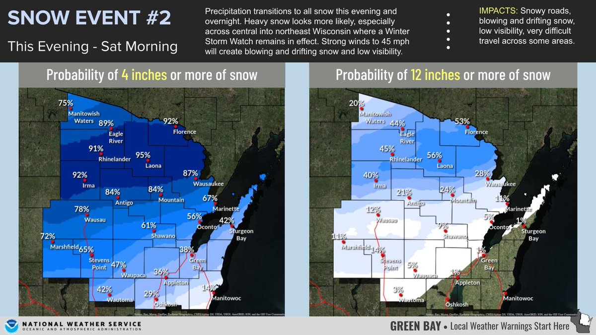
(920 PM) Latest trends are showing the narrow band of heavy snow more than likely will shift 20 to 30 miles to the north later on tonight thru Saturday morning. Here are the updated snowfall totals thru Saturday morning and the latest winter weather advisories. #wiwx

(920 PM) Latest trends are showing the narrow band of heavy snow more than likely will shift 20 to 30 miles to the north later on tonight thru Saturday morning. Here are the updated snowfall totals thru Saturday morning and the latest winter weather advisories. #wiwx
👉Birdhism.bsky.social (@birdhism) 's Twitter Profile Photo

Flavio Meira Silva 🦜🇧🇷🔺️ Oh yeah, that’s mine. If you’d like to support me and see more chubby birds, please visit birdhism.com and learn something new about our feathered friends.

The Roost (@theroost10) 's Twitter Profile Photo

Check out Morty’s June 2023 Beneath the Cage Grate column! #birds #parrots #blogs theroostonline.blog/2023/06/04/bot…

NWS Green Bay (@nwsgreenbay) 's Twitter Profile Photo

Strong to severe thunderstorms will remain possible on Friday as a cold front drops south across the region. The greatest risk of severe weather will occur over central to east-central Wisconsin between 2 pm and 6 pm. #wiwx

Strong to severe thunderstorms will remain possible on Friday as a cold front drops south across the region.  The greatest risk of severe weather will occur over central to east-central Wisconsin between 2 pm and 6 pm.  #wiwx
NWS Green Bay (@nwsgreenbay) 's Twitter Profile Photo

Update | Winter Storm: Fri-Sat ⚠️ Snow totals of 6 -12" are expected across much of the region. Highest across eastern WI ⚠️ Expect snow to start spreading SW to NE beginning early Fri AM. ⚠️Worst conditions are expected late Fri aftn/night as NE winds gust over 40 mph.#wiwx

Update | Winter Storm: Fri-Sat
⚠️ Snow totals of 6 -12" are expected across much of the region. Highest across eastern WI
⚠️ Expect snow to start spreading SW to NE beginning early Fri AM. 
⚠️Worst conditions are expected late Fri aftn/night as NE winds gust over 40 mph.#wiwx
NWS Green Bay (@nwsgreenbay) 's Twitter Profile Photo

Looking ahead to what's coming behind Fri-Sat winter storm much colder temps will be arriving Sunday with highs in the single digits. Wind chill temps are expected to be well below 0 to begin next week with low wind chills approaching negative 20-30 degrees at times. #wiwx

Looking ahead to what's coming behind Fri-Sat winter storm much colder temps will be arriving Sunday with highs in the single digits. Wind chill temps are expected to be well below 0 to begin next week with low wind chills approaching negative 20-30 degrees at times. #wiwx
NWS Green Bay (@nwsgreenbay) 's Twitter Profile Photo

Following the winter storm, a surge of arctic air push into the area. High temps mainly in the single digits above zero Sunday-Tuesday. Morning lows well below zero. Dangerous wind chills as low as -20 to -35 at times. Ice jams. #wiwx

Following the winter storm, a surge of arctic air push into the area. High temps mainly in the single digits above zero Sunday-Tuesday. Morning lows well below zero. Dangerous wind chills as low as -20 to -35 at times. Ice jams. #wiwx