Yaqueline
@yaque04804330
Aficionada del clima y de los fenómenos Meteorológicos - Informática en progreso - Conocer sobre la meteorología es mi pasión - Amo la lectura 📖
ID: 1395221953145974784
https://meteorologiayclima2746.blogspot.com/ 20-05-2021 03:37:20
3,3K Tweet
651 Followers
669 Following
 's Twitter Profile Photo")
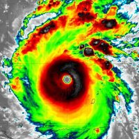
![[Huracán Enri 5 PM]
Mantiene vientos de 160 mph y su movimiento hacia el oeste a 280 grados. Se mueve más lento a 15 mph/24 kmh con una presión de 915 mb.
El llegó a la latitud 20 Norte con longitud 64 Oeste, que es a 135 millas de Anguila y 175 millas de San Juan.
El gobierno](https://pbs.twimg.com/media/GygHHXvXgAAghj2.jpg "CycloforumsPR (@cycloforumspr) on Twitter photo [Huracán Enri 5 PM]
Mantiene vientos de 160 mph y su movimiento hacia el oeste a 280 grados. Se mueve más lento a 15 mph/24 kmh con una presión de 915 mb.
El llegó a la latitud 20 Norte con longitud 64 Oeste, que es a 135 millas de Anguila y 175 millas de San Juan.
El gobierno")
 's Twitter Profile Photo")
 's Twitter Profile Photo")
 on Twitter photo 20AGO2025
Se observa nuestro país con lluvias en varias partes, tome en cuenta que viene acompañado de actividad eléctrica y vientos
Atentos y precaución")
 's Twitter Profile Photo")
![DATOS REVISADOS: Sismo mag. 6.0, frente a costa de Ahuachapán. A 80.0 km al suroeste de Barra de Santiago. Prof. 20 km. [2025-08-23, 03:14:23]](https://pbs.twimg.com/media/GzBszFuWYAAWNYz.jpg "Ministerio de Medio Ambiente (@medioambientesv) on Twitter photo DATOS REVISADOS: Sismo mag. 6.0, frente a costa de Ahuachapán. A 80.0 km al suroeste de Barra de Santiago. Prof. 20 km. [2025-08-23, 03:14:23]")
 on Twitter photo 24AGO2025
Después de desaparecerme unos días de este espacio, he vuelto nuevamente, para avisarles que se está vigilando esta X (color naranja), por el momento se mantiene en vigilancia a este sistema bajo el nombre de INVEST 99L
2 días: 40%
7 días: 40%")
 on Twitter photo Que la tranquilidad del final de agosto en el Atlántico y África, no genere sobreconfianza con septiembre.
ADM")
 's Twitter Profile Photo")
 on Twitter photo On this day in 2020, the state of Louisiana was about to endure their strongest Hurricane landfall in 164 years.")
 's Twitter Profile Photo")
 on Twitter photo Que la tranquilidad de final de Agosto no te deje ciego.
La Perspectiva del CPC indica medianas probabilidades para la primera semana de septiembre 3 al 10, ~20%.
La tercera semana del 10 al 16 ~40/60% de desarrollo tropical en el MDR.
¿Abrocharse el cinturón? 🌀")
 on Twitter photo 20 years ago, the NHC’s forecast cone for KATRINA finally began to narrow down eastern Louisiana as the landfall site.
Meanwhile, KATRINA had just strengthened into a Category 3 major hurricane. The intensity forecast called for a 125 kt (145 mph) Category 4 peak intensity —")
 's Twitter Profile Photo")
 's Twitter Profile Photo")
 on Twitter photo Almost at the peak of season, September 10th. Over the past decade, we've had destructive storms on or after that date (Matthew, Irma, Maria, Florence, Michael, Sally, Delta, Zeta, Ian, Helene, Milton...to name a few). Hope for the best, always stay alert and updated.")
 's Twitter Profile Photo")
 on Twitter photo 20 years ago tomorrow... this was the view in the Gulf:
#Katrina")
 's Twitter Profile Photo")
 on Twitter photo Hurricane #Katrina (2005) at peak intensity in the Gulf of Mexico, 20 years ago today.
Terra MODIS | 2005-08-28 17Z
IR (band 31) eye temp: 23.7°C
WV (band 27) eye temp: -20.2°C")
 on Twitter photo This photo, 20 years later, remains one of the greatest images ever taken inside Hurricane KATRINA.
The Hurricane Hunters view of KATRINA’s eye, with the eyewall visible. At the time, it packed winds of 150 kts (175 mph) and a pressure of 902 mb.")
 's Twitter Profile Photo")
 on Twitter photo 20 Years Ago Today: This image of Hurricane Katrina was captured at Category 5 intensity in the Gulf of Mexico. A near-perfectly symmetrical monster storm, heading straight for Southeast Louisiana.")
 on Twitter photo 2PM; El NHC aumenta a 50%las probabilidades de desarrollo a la onda tropical a sur de CV, 10% en 48 horas. Seguimos vigilando 🌀.")