Max Golembo (@wx_max) 's Twitter Profile
Max Golembo

@wx_max

Senior Meteorologist/Weather Producer for ABC News and Good Morning America. UAlbany Grad

ID: 1346942144

calendar_today12-04-2013 14:21:25

54,54K Tweet

4,4K Followers

5,5K Following

National Hurricane Center (@nhc_atlantic) 's Twitter Profile Photo

11am EDT Mon Aug 11th - Tropical Storm #Erin has formed in the far eastern tropical Atlantic just west of the Cabo Verde Islands. Maximum sustained winds are 45 mph & intensification is forecast as it moves westward across the open tropical Atlantic. hurricanes.gov

11am EDT Mon Aug 11th - Tropical Storm #Erin has formed in the far eastern tropical Atlantic just west of the Cabo Verde Islands.

Maximum sustained winds are 45 mph & intensification is forecast as it moves westward across the open tropical Atlantic.

hurricanes.gov
NWS Las Vegas (@nwsvegas) 's Twitter Profile Photo

Monsoon, where are you?!?! The weather pattern much of the summer has favored dry conditions thanks to an active jet stream across the PacNW. This has kept monsoon moisture well to our east, but has also kept the summer cooler than recent years. #cawx #nvwx #azwx #vegasweather

Monsoon, where are you?!?! The weather pattern much of the summer has favored dry conditions thanks to an active jet stream across the PacNW. This has kept monsoon moisture well to our east, but has also kept the summer cooler than recent years. #cawx #nvwx #azwx #vegasweather
Michael Ferragamo (@ferragamowx) 's Twitter Profile Photo

Out of all 93 tropical cyclones to ever pass within 150 miles of #ERIN's current location, only 6 (or 6.5%) have ever made landfall in the US. They include: SEA ISLANDS 1893 NEW ENGLAND 1938 GLORIA 1985 IKE 2008 IRMA 2017 FLORENCE 2018 Historically speaking, it's pretty

Out of all 93 tropical cyclones to ever pass within 150 miles of #ERIN's current location, only 6 (or 6.5%) have ever made landfall in the US. They include:

SEA ISLANDS 1893
NEW ENGLAND 1938
GLORIA 1985
IKE 2008
IRMA 2017
FLORENCE 2018

Historically speaking, it's pretty
National Hurricane Center (@nhc_atlantic) 's Twitter Profile Photo

Aug 16: Images from NOAA Aircraft Operations Center and the NOAA Satellites Ocean Winds team show an intense eyewall in Hurricane #Erin This photo shows the ocean surface calm in the eye and roaring in the eyewall. For the latest forecast visit hurricanes.gov
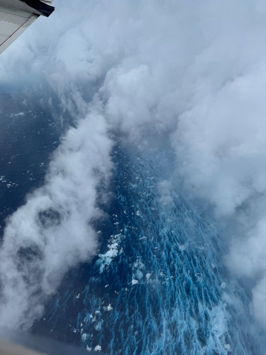
Aug 16: Images from <a href="/NOAA_HurrHunter/">NOAA Aircraft Operations Center</a> and the <a href="/NOAASatellites/">NOAA Satellites</a> Ocean Winds team show an intense eyewall in Hurricane #Erin This photo shows the ocean surface calm in the eye and roaring in the eyewall. For the latest forecast visit hurricanes.gov
National Weather Service (@nws) 's Twitter Profile Photo

A large portion of the Atlantic coastline will see the risk for high surf and rip currents increase this week due to #Erin. 🟥Risk of Rip Currents is High🟥 Life-threatening rip currents are likely. Swimming conditions are unsafe for all levels of swimmers. Stay out of the

A large portion of the Atlantic coastline will see the risk for high surf and rip currents increase this week due to #Erin. 

🟥Risk of Rip Currents is High🟥
Life-threatening rip currents are likely. Swimming conditions are unsafe for all levels of swimmers. Stay out of the
National Weather Service (@nws) 's Twitter Profile Photo

NWS is hiring! Additional top-priority hiring efforts for mission-critical positions have been posted on USAJobs.gov! Openings for Hydrologist positions (1315 series) were posted TODAY. Many of these positions are great opportunities for first-time hires into the NWS.

NWS is hiring! Additional top-priority hiring efforts for mission-critical positions have been posted on USAJobs.gov! Openings for Hydrologist positions (1315 series) were posted TODAY. Many of these positions are great opportunities for first-time hires into the NWS.
NHC_TAFB (@nhc_tafb) 's Twitter Profile Photo

Checking in on a tropical wave we are monitoring for tropical cyclone development. This wave currently has a a HIGH chance of becoming a tropical cyclone in the next 7 days. 🌀 Visit hurricanes.gov for more information!

NWS Tampa Bay (@nwstampabay) 's Twitter Profile Photo

The NHC is monitoring a tropical wave with a 90% chance of development in the next 7 days. While it's too early to determine if there's any threat to our area, it's a good reminder to be sure to get your information from reliable sources and be careful of social media hype! #flwx

The NHC is monitoring a tropical wave with a 90% chance of development in the next 7 days. While it's too early to determine if there's any threat to our area, it's a good reminder to be sure to get your information from reliable sources and be careful of social media hype! #flwx
Jeff Berardelli (@weatherprof) 's Twitter Profile Photo

Now 90% chance of development on Invest #91L. But there is an unusually large amount of uncertainty with both the level of development/ intensity and also the eventual track. At this point all that can be known with any certainty is that the Lesser Antilles will need to be on

Now 90% chance of development on Invest #91L. But there is an unusually large amount of uncertainty with both the level of development/ intensity and also the eventual track. At this point all that can be known with any certainty is that the Lesser Antilles will need to be on
Ben Noll (@bennollweather) 's Twitter Profile Photo

The risk for a tropical system near the Caribbean islands later next week is rising, with most ECMWF ensemble members favoring a more southerly track. It's currently uncertain how strong it will be. People across the islands and United States should monitor this closely.

The risk for a tropical system near the Caribbean islands later next week is rising, with most ECMWF ensemble members favoring a more southerly track.

It's currently uncertain how strong it will be.

People across the islands and United States should monitor this closely.
National Hurricane Center (@nhc_atlantic) 's Twitter Profile Photo

8 pm ET Sep 4: A tropical depression is likely to form over the central tropical Atlantic by this weekend. The system could be near the Lesser Antilles by the middle to latter part of next week. Formation chances: Next 2 days:🟠 Medium (60%) Next 7 days:🔴 High (90%) Visit

8 pm ET Sep 4: A tropical depression is likely to form over the central tropical Atlantic by this weekend. The system could be near the Lesser Antilles by the middle to latter part of next week.

Formation chances:
Next 2 days:🟠 Medium (60%)
Next 7 days:🔴 High (90%)

Visit
NWS Mount Holly (@nws_mountholly) 's Twitter Profile Photo

A thunderstorm is approaching south Philadelphia. At this time, the primary threats are lightning and brief downpours. A Severe Thunderstorm Warning is not currently in effect. #PAwx