Weather Peens
@weatherpeens
weather-related things that vaguely resemble peens. powered by an extensive network of spotters providing field reports. based on research by @johnny_reina
ID: 1039583878636298240
11-09-2018 18:38:05
389 Tweet
6,6K Followers
69 Following
 's Twitter Profile Photo")
 on Twitter photo Severe thunderstorms are possible this afternoon and evening from northeast Colorado into southwest Nebraska and far northwest Kansas. Strong to isolated severe thunderstorms are also possible this afternoon and evening across parts of the eastern Great Basin/northern")
 's Twitter Profile Photo")
 's Twitter Profile Photo")
 on Twitter photo #WPC_MD 0974 affecting south Texas through the middle Texas coast, #txwx, wpc.ncep.noaa.gov/metwatch/metwa…")
 's Twitter Profile Photo")
 's Twitter Profile Photo")
 on Twitter photo 11:41pm CST #SPC Day1 Outlook spc.noaa.gov/products/outlo…")
 's Twitter Profile Photo")
 on Twitter photo Widespread travel problems will unfold and bitterly cold air will follow in many areas. bit.ly/3DB9dLT")
 's Twitter Profile Photo")
 on Twitter photo Winter Weather Advisories have been issued for all of north-central and northeast Wisconsin. Most locations to see 3-6\" of snow. We are still watching for the potential of a narrow snow band that could impact the area with locally greater than 6\" of snow. #wiwx")
 's Twitter Profile Photo")
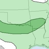
 on Twitter photo Looks like this storm is going to aggressively penetrate the Deep South. Stay alert.")
 on Twitter photo 12:30pm CDT #SPC Day2 Outlook Enhanced Risk: ACROSS A BROAD AREA CENTERED OVER THE OHIO/MID MISSISSIPPI/TENNESSEE VALLEYS spc.noaa.gov/products/outlo…")
 on Twitter photo 12:47am CDT #SPC Day2 Outlook Slight Risk: in the Upper OH Valley and central Appalachians spc.noaa.gov/products/outlo…")
 on Twitter photo 2:23am CDT #SPC Day3 Outlook Slight Risk: in IA/northern MO/eastern NE spc.noaa.gov/products/outlo…")
 's Twitter Profile Photo")
 on Twitter photo wxtwt jumpscare")
 on Twitter photo HP #WeatherPeen intercepted over Ropesville, TX by the WeatherPeens chase team")
 on Twitter photo 11:51pm CDT #SPC Day1 #FireWX Critical: portions of northern california spc.noaa.gov/products/fire_…")
 's Twitter Profile Photo")
 on Twitter photo Thunderstorms along the I-70 corridor in northwest Kansas will slowly track northward through 7:30 pm MDT this evening (Monday August 18, 2025). Torrential rainfall and 50-60 mph wind gusts can be expected with any storms. #kswx #cowx #newx")