Jesse Ferrell (@weathermatrix) 's Twitter Profile
Jesse Ferrell

@weathermatrix

Jesse Ferrell, AccuWeather Meteorologist & Digital producer. Opinions my own.

WeatherMatrix, Since 1996: "The Weather is Always Interesting."

ID: 14834076

linkhttps://weathermatrix.accuweather.com calendar_today19-05-2008 15:45:32

47,47K Tweet

9,9K Followers

1,1K Following

Jesse Ferrell (@weathermatrix) 's Twitter Profile Photo

From the size of this waterspout and the lightning nearby, this was likely a supercell tornado over water. facebook.com/watch/?v=15232…

Giovanni Rizzotti (@gio_wx) 's Twitter Profile Photo

2 hours later and this supercell is STILL going with strong rotation going in and out. Currently located south of Mishkeegogamang, Ontario. This is gonna be one long, extensive satellite imagery review… #onstorm

2 hours later and this supercell is STILL going with strong rotation going in and out. Currently located south of Mishkeegogamang, Ontario. This is gonna be one long, extensive satellite imagery review… #onstorm
AccuWeather (@accuweather) 's Twitter Profile Photo

Americans may disagree on whether to call them fireflies or lightning bugs, but the weather has made for a great year for the blinking bugs. 🪲✨ bit.ly/4lo4cX7

NWS Las Vegas (@nwsvegas) 's Twitter Profile Photo

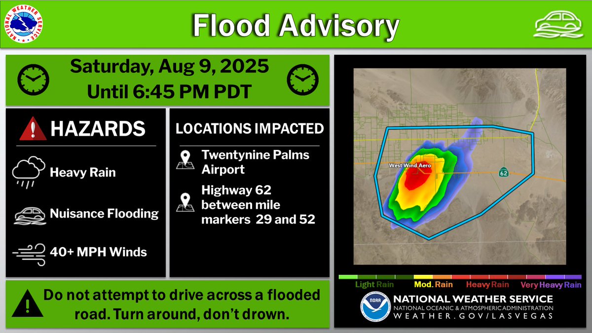
⚠️Flood Advisory⚠️ 📍Southern San Bernardino County in California, including the Twentynine Palms Airport ⏰Until 6:45 pm PDT 🌧️Radar indicates that up to half an inch of rain has fallen within 30 minutes, which will be capable of producing nuisance flooding on HWY 62. #CAwx

⚠️Flood Advisory⚠️

📍Southern San Bernardino County in California, including the Twentynine Palms Airport
⏰Until 6:45 pm PDT

🌧️Radar indicates that up to half an inch of rain has fallen within 30 minutes, which will be capable of producing nuisance flooding on HWY 62. #CAwx
Jesse Ferrell (@weathermatrix) 's Twitter Profile Photo

Hail as large as 3" across was reported with this storm which at one time had a Destructive tag in the Severe Thunderstorm Warning near Limon, CO.

Jesse Ferrell (@weathermatrix) 's Twitter Profile Photo

Tornado near Wray, home of the insane tornado Reed Timmer, PhD filmed in 2016 (youtube.com/watch?v=bjb7Qt…) "At 551 PM MDT, a confirmed tornado was located 9 miles south of Wray, moving southeast at 25 mph."

Tornado near Wray, home of the insane tornado <a href="/ReedTimmerUSA/">Reed Timmer, PhD</a> filmed in 2016 (youtube.com/watch?v=bjb7Qt…)

"At 551 PM MDT, a confirmed tornado was located 9 miles south of Wray, moving southeast at 25 mph."
Met Office (@metoffice) 's Twitter Profile Photo

Smoke from Canadian wildfires is clearly visible in this morning’s satellite imagery 🛰️ and it could lead to some striking sunrises and sunsets over the next couple of days 🌄

Andy Hazelton (@andyhazelton) 's Twitter Profile Photo

Still a lot of uncertainty in the long term track of #97L, partially tied to both the initial strength/trajectory of the system and also the strength of the West Atlantic ridging in about a week. Ensemble spread ranges from a quick recurve east of Bermuda to a trek into the

Still a lot of uncertainty in the long term track of #97L, partially tied to both the initial strength/trajectory of the system and also the strength of the West Atlantic ridging in about a week. Ensemble spread ranges from a quick recurve east of Bermuda to a trek into the
Chris |☇uball (@chriskuball) 's Twitter Profile Photo

Five years ago today… the 2020 Derecho cut across Iowa and the Midwest. This is one of the most intense wind setups from Midwest thunderstorms ever. The strongest wind in Iowa raged from Carroll, eastward along the US30/I80 corridor. The derecho intensified as it moved east

Five years ago today… the 2020 Derecho cut across Iowa and the Midwest.  This is one of the most intense wind setups from Midwest thunderstorms ever. 

The strongest wind in Iowa raged from Carroll, eastward along the US30/I80 corridor.  The derecho intensified as it moved east
Jacob Feuerstein (@jacob_feuer) 's Twitter Profile Photo

Extreme rain event centered on Milwaukee overnight, more than 14” locally recorded with additional downpours moving through. Probably one of the biggest in state history. Very well forecasted by the local WFO and the WPC, who issued a moderate risk despite so-so model support.

Extreme rain event centered on Milwaukee overnight, more than 14” locally recorded with additional downpours moving through. Probably one of the biggest in state history. Very well forecasted by the local WFO and the WPC, who issued a moderate risk despite so-so model support.
Zach Nice (@supercane7) 's Twitter Profile Photo

And another morning ASCAT pass right after I post! This morning it looks like #97L still has a well defined LLC and is now producing winds to TS force. TS #Erin should be designated this morning.

And another morning ASCAT pass right after I post! This morning it looks like #97L still has a well defined LLC and is now producing winds to TS force. TS #Erin should be designated this morning.
Jesse Ferrell (@weathermatrix) 's Twitter Profile Photo

Most but not all ECMWF & Google models keep the hurricane offshore but it's still too close for comfort. Once it gets close to Bermuda, there are two scenarios. Bernie will be doing a video on these and we'll be discussing here soon: accuweather.com/en/hurricane/f…

Most but not all ECMWF &amp; Google models keep the hurricane offshore but it's still too close for comfort. Once it gets close to Bermuda, there are two scenarios. Bernie will be doing a video on these and we'll be discussing here soon: accuweather.com/en/hurricane/f…