Taylor Stephenson, CBM (@tstephwx) 's Twitter Profile
Taylor Stephenson, CBM

@tstephwx

Certified Broadcast Meteorologist at 13News Now | From GA to VA ✈️| @ousom alumna | AKA💕💚| #IfTayDontSayIt #ThenItsNotTrue | Views are my own!

ID: 915726481908797440

linkhttp://13newsnow.com calendar_today04-10-2017 23:53:01

2,2K Tweet

1,1K Takipçi

770 Takip Edilen

Food Network (@foodnetwork) 's Twitter Profile Photo

We are deeply saddened to share the news that beloved chef, Anne Burrell, passed away this morning. Anne was a remarkable person and culinary talent – teaching, competing and always sharing the importance of food in her life and the joy that a delicious meal can bring. Our

We are deeply saddened to share the news that beloved chef, Anne Burrell, passed away this morning. Anne was a remarkable person and culinary talent – teaching, competing and always sharing the importance of food in her life and the joy that a delicious meal can bring. Our
Kamilah Williams (@kayintheknow) 's Twitter Profile Photo

Big news—today’s my first day as a reporter at WTKR News 3 🎥 Excited to call Hampton Roads home and start covering the amazing stories in Portsmouth. Let’s go! 💪🎤 #WTKR #PortsmouthVA #HamptonRoads #ReporterLife

Big news—today’s my first day as a reporter at <a href="/WTKR3/">WTKR News 3</a> 🎥
Excited to call Hampton Roads home and start covering the amazing stories in Portsmouth. Let’s go! 💪🎤
#WTKR #PortsmouthVA #HamptonRoads #ReporterLife
DIAMOND DUNES (@diamonddunes) 's Twitter Profile Photo

A short lived, radioactive and unstable element. Solid at room temp and the second highest atomic number!! SHOUTS OUT TO SIS! I’ll be excited to understand what it can do .. keep researching folks 🥰🥰🥰

National Weather Service (@nws) 's Twitter Profile Photo

NWS is hiring! The first of several top-priority, mission-critical positions posted Friday on USAJobs.gov! Others will follow soon. Visit USAJobs.gov and search “NWS” to learn more.

NWS is hiring! The first of several top-priority, mission-critical positions posted Friday on USAJobs.gov!

Others will follow soon. Visit USAJobs.gov and search “NWS” to learn more.
NWS Bay Area 🌉 (@nwsbayarea) 's Twitter Profile Photo

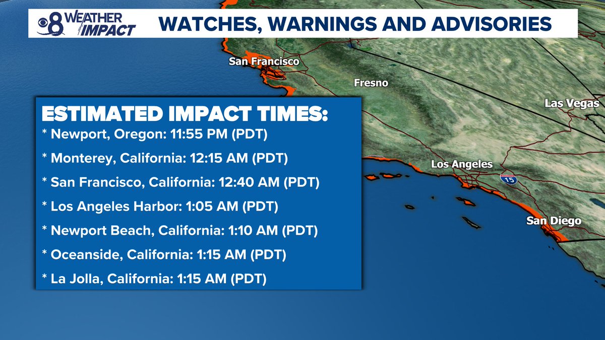
⚠️TSUNAMI WATCH in effect for the California coast. Estimated time of arrival as early as 12:15 AM on July 30. People along the coast: Stand by for further updates. #KnowYourZone at conservation.ca.gov/cgs/tsunami/ma… #CAwx #Tsunami

⚠️TSUNAMI WATCH in effect for the California coast. Estimated time of arrival as early as 12:15 AM on July 30. People along the coast: Stand by for further updates. #KnowYourZone at conservation.ca.gov/cgs/tsunami/ma… #CAwx #Tsunami
Matthew Cappucci (@matthewcappucci) 's Twitter Profile Photo

A few things we know: – BIGGEST quake in 14 years (8.8 is incredible) – MEGATHRUST quake (Pacific plate slides beneath Okhotsk plate – Very favorable for damaging tsunami – Tsunami already observed in Kamchatka Peninsula – Vertical displacement of sea floor

Hurricane Hunters (@53rdwrs) 's Twitter Profile Photo

Last night, the 53rd Weather Reconnaissance Squadron flew into the eye of Hurricane Erin—and captured imagery of the breathtaking stadium effect. These missions provide critical data to the NHC to improve forecasts, helping keep communities safe before the storm makes

Michael Ferragamo (@ferragamowx) 's Twitter Profile Photo

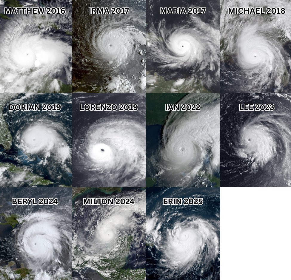
Here’s all eleven Category 5 Atlantic hurricanes since 2016 — the most ever recorded in a 9-year timeframe in our database (since 1851). A remarkable period of recent intense activity, especially considering the Atlantic saw no Category 5 hurricanes from 2008-2015.

Here’s all eleven Category 5 Atlantic hurricanes since 2016 — the most ever recorded in a 9-year timeframe in our database (since 1851).

A remarkable period of recent intense activity, especially considering the Atlantic saw no Category 5 hurricanes from 2008-2015.
NWS Wakefield (@nwswakefieldva) 's Twitter Profile Photo

Even though #HurricaneErin will not make landfall, we will still experience multiple hazards across the area. As Erin’s wind field expands, tropical-storm-force gusts of 40 to 50 mph are expected along the coast, which could result in tree damage and power outages. #vawx #ncwx

Even though #HurricaneErin will not make landfall, we will still experience multiple hazards across the area. As Erin’s wind field expands, tropical-storm-force gusts of 40 to 50 mph are expected along the coast, which could result in tree damage and power outages. #vawx #ncwx
SamWalkerOBXNews.com🎙📻📰🥍🦓 (@samwalkerobx) 's Twitter Profile Photo

Brian McArthur got a little up close and personal with the overwash on N.C. 12 at the north end of Hatteras village this evening! #yestv #Erin #ncwx #obx

Jamie Arnold WMBF (@jamiearnoldwmbf) 's Twitter Profile Photo

And there goes Erin fading away into the North Atlantic. It never made it to category 6. It didn’t suddenly veer left into Florida. It wasn’t created by HAARP. It wasn’t directed into the Carolinas by laser beams from radars. It wasn’t seeded for sinister purposes. It’s not

And there goes Erin fading away into the North Atlantic.  It never made it to category 6.  It didn’t suddenly veer left into Florida.  It wasn’t created by HAARP.  It wasn’t directed into the Carolinas by laser beams from radars.  It wasn’t seeded for sinister purposes.  It’s not
AccuWeather (@accuweather) 's Twitter Profile Photo

NASA images show Hurricane Erin spinning 600 miles off the Northeast coast today — in nearly the same spot Erin was on Sept. 11, 2001. 🌀

NASA images show Hurricane Erin spinning 600 miles off the Northeast coast today — in nearly the same spot Erin was on Sept. 11, 2001. 🌀
NWS Wakefield (@nwswakefieldva) 's Twitter Profile Photo

We are closely watching the development of this system. There are still a lot of uncertainties regarding its future path & potential impacts, so stay tuned as we work to refine the details. Be cautious of what information you follow/look at online as models continue to change.