Remote Sensing MDPI (@remotesens_mdpi) 's Twitter Profile
Remote Sensing MDPI

@remotesens_mdpi

No. 1 #remotesensing #openaccess journal in Remote Sensing Category in #WoS, published by @MDPIOpenAccess; IF 2023 4.2; CiteScore 2023 8.3; #mdpiremotesensing

ID: 3376897745

linkhttp://www.mdpi.com/journal/remotesensing calendar_today15-07-2015 05:11:07

14,14K Tweet

20,20K Takipรงi

906 Takip Edilen

Remote Sensing MDPI (@remotesens_mdpi) 's Twitter Profile Photo

๐Ÿ‘‰๐Ÿ‘‰ MVG-Net: #LiDAR #PointCloud Semantic #Segmentation Network Integrating Multi-View #Images โœ๏ธ Yongchang Liu et al. ๐Ÿ”— brnw.ch/21wTVo7

๐Ÿ‘‰๐Ÿ‘‰ MVG-Net: #LiDAR #PointCloud Semantic #Segmentation Network Integrating Multi-View #Images

โœ๏ธ Yongchang Liu et al.
๐Ÿ”— brnw.ch/21wTVo7
Remote Sensing MDPI (@remotesens_mdpi) 's Twitter Profile Photo

๐Ÿ”ฅ๐ŸŒณ Fire-Net: Rapid Recognition of #Forest #Fires in #UAV Remote Sensing #Imagery Using Embedded #Devices โœ๏ธ Shouliang Li et al. ๐Ÿ”— brnw.ch/21wTVog

๐Ÿ”ฅ๐ŸŒณ Fire-Net: Rapid Recognition of #Forest #Fires in #UAV Remote Sensing #Imagery Using Embedded #Devices

โœ๏ธ Shouliang Li et al.
๐Ÿ”— brnw.ch/21wTVog
Remote Sensing MDPI (@remotesens_mdpi) 's Twitter Profile Photo

๐Ÿ‘‹๐Ÿ‘‹ Automatic Detection of Quasi-Periodic #Emissions from #Satellite Observations by Using #DETR #Method โœ๏ธ Zilin Ran et al. ๐Ÿ”— brnw.ch/21wTVok

๐Ÿ‘‹๐Ÿ‘‹ Automatic Detection of Quasi-Periodic #Emissions from #Satellite Observations by Using #DETR #Method

โœ๏ธ Zilin Ran et al.
๐Ÿ”— brnw.ch/21wTVok
Remote Sensing MDPI (@remotesens_mdpi) 's Twitter Profile Photo

๐Ÿ–ผ๏ธ๐Ÿ–ผ๏ธ Optimization of #RemoteSensing #Image- #Segmentation Decoder Based on Multi-Dilation and Large-Kernel #Convolution โœ๏ธ Guohong Liu et al. ๐Ÿ”— brnw.ch/21wTVop

๐Ÿ–ผ๏ธ๐Ÿ–ผ๏ธ Optimization of #RemoteSensing #Image- #Segmentation Decoder Based on Multi-Dilation and Large-Kernel #Convolution

โœ๏ธ Guohong Liu et al.
๐Ÿ”— brnw.ch/21wTVop
Remote Sensing MDPI (@remotesens_mdpi) 's Twitter Profile Photo

๐Ÿ‘‰๐Ÿ‘‰ A Novel Sample Generation Method for #DeepLearning #Lithological Mapping with Airborne #TASI #Hyperspectral Data in Northern Liuyuan, Gansu, #China โœ๏ธ Huize Liu et al. ๐Ÿ”— brnw.ch/21wTVot

๐Ÿ‘‰๐Ÿ‘‰ A Novel Sample Generation Method for #DeepLearning #Lithological Mapping with Airborne #TASI #Hyperspectral Data in Northern Liuyuan, Gansu, #China

โœ๏ธ Huize Liu et al.
๐Ÿ”— brnw.ch/21wTVot
Remote Sensing MDPI (@remotesens_mdpi) 's Twitter Profile Photo

โ€ผ๏ธโ€ผ๏ธ Performance Analysis of an #Aerial Remote Sensing Platform Based on Real-Time #Satellite #Communication and Its Application in Natural #Disaster #Emergency Response โœ๏ธ Xiangli He et al. ๐Ÿ”— brnw.ch/21wTVP8

โ€ผ๏ธโ€ผ๏ธ Performance Analysis of an #Aerial Remote Sensing Platform Based on Real-Time #Satellite #Communication and Its Application in Natural #Disaster #Emergency Response

โœ๏ธ Xiangli He et al.
๐Ÿ”— brnw.ch/21wTVP8
Remote Sensing MDPI (@remotesens_mdpi) 's Twitter Profile Photo

๐Ÿ“ƒ๐Ÿ“ƒ Spatial Models of #Solar and Terrestrial #Radiation Budgets and #MachineLearning: A #Review โœ๏ธ Juliรกn Guillermo Garcรญa Pedreros et al. ๐Ÿ”— brnw.ch/21wTVPe

๐Ÿ“ƒ๐Ÿ“ƒ Spatial Models of #Solar and Terrestrial #Radiation Budgets and #MachineLearning: A #Review

โœ๏ธ Juliรกn Guillermo Garcรญa Pedreros et al.
๐Ÿ”— brnw.ch/21wTVPe
Remote Sensing MDPI (@remotesens_mdpi) 's Twitter Profile Photo

๐ŸŒณ๐ŸŒฒ Evaluating #Tree #Species Mapping: Probability Sampling Validation of Pure and Mixed Species Classes Using Convolutional #NeuralNetworks and #Sentinel2 Time Series โœ๏ธ Tobias Schadauer et al. ๐Ÿ”— brnw.ch/21wTVPm

๐ŸŒณ๐ŸŒฒ Evaluating #Tree #Species Mapping: Probability Sampling Validation of Pure and Mixed Species Classes Using Convolutional #NeuralNetworks and #Sentinel2 Time Series

โœ๏ธ Tobias Schadauer et al.
๐Ÿ”— brnw.ch/21wTVPm
Remote Sensing MDPI (@remotesens_mdpi) 's Twitter Profile Photo

๐Ÿ–ผ๏ธ๐Ÿ–ผ๏ธ MGCET: MLP-mixer and #Graph #Convolutional Enhanced Transformer for #Hyperspectral Image #Classification โœ๏ธ Mohammed A. A. Al-qaness et al. ๐Ÿ”— brnw.ch/21wTVPu

๐Ÿ–ผ๏ธ๐Ÿ–ผ๏ธ MGCET: MLP-mixer and #Graph #Convolutional Enhanced Transformer for #Hyperspectral Image #Classification

โœ๏ธ Mohammed A. A. Al-qaness et al.
๐Ÿ”— brnw.ch/21wTVPu
Remote Sensing MDPI (@remotesens_mdpi) 's Twitter Profile Photo

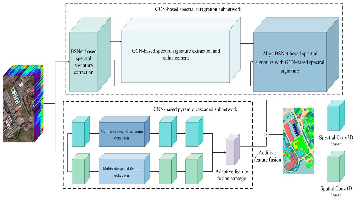
๐Ÿ–ผ๏ธ๐Ÿ–ผ๏ธ #Pyramid Cascaded Convolutional #NeuralNetwork with Graph Convolution for #Hyperspectral Image #Classification โœ๏ธ Haizhu Pan et al. ๐Ÿ”— brnw.ch/21wTVPN

๐Ÿ–ผ๏ธ๐Ÿ–ผ๏ธ #Pyramid Cascaded Convolutional #NeuralNetwork with Graph Convolution for #Hyperspectral Image #Classification

โœ๏ธ Haizhu Pan et al.
๐Ÿ”— brnw.ch/21wTVPN
Remote Sensing MDPI (@remotesens_mdpi) 's Twitter Profile Photo

๐Ÿ‘‰๐Ÿ‘‰ An Effective and Lightweight Full-Scale #Target #Detection Network for #UAV Images Based on Deformable #Convolutions and Multi-Scale Contextual #Feature Optimization โœ๏ธ Wanwan Yu et al. ๐Ÿ”— brnw.ch/21wTVQE

๐Ÿ‘‰๐Ÿ‘‰ An Effective and Lightweight Full-Scale #Target #Detection Network for #UAV Images Based on Deformable #Convolutions and Multi-Scale Contextual #Feature Optimization

โœ๏ธ Wanwan Yu et al.
๐Ÿ”— brnw.ch/21wTVQE
Remote Sensing MDPI (@remotesens_mdpi) 's Twitter Profile Photo

โš“โš“ #Cascaded-Filter-Based Reverberation Suppression #Method of Short-Pulse Continuous #Wave for Active #Sonar โœ๏ธ Yonglin Cui et al. ๐Ÿ”— brnw.ch/21wTVRA

โš“โš“ #Cascaded-Filter-Based Reverberation Suppression #Method of Short-Pulse Continuous #Wave for Active #Sonar

โœ๏ธ Yonglin Cui et al.
๐Ÿ”— brnw.ch/21wTVRA
Remote Sensing MDPI (@remotesens_mdpi) 's Twitter Profile Photo

๐Ÿ‘‹๐Ÿ‘‹ An Innovative Internal #Calibration Strategy and Implementation for LT-1 #Bistatic Spaceborne #SAR โœ๏ธ Yuanbo Jiao et al. ๐Ÿ”— brnw.ch/21wTVUt

๐Ÿ‘‹๐Ÿ‘‹ An Innovative Internal #Calibration Strategy and Implementation for LT-1 #Bistatic Spaceborne #SAR

โœ๏ธ Yuanbo Jiao et al.
๐Ÿ”— brnw.ch/21wTVUt
Remote Sensing MDPI (@remotesens_mdpi) 's Twitter Profile Photo

๐ŸŒก๏ธ๐ŸŒก๏ธ #Geometric Factor #Correction Algorithm Based on #Temperature and Humidity Profile #Lidar โœ๏ธ Bowen Zhang et al. ๐Ÿ”— brnw.ch/21wTVVG

๐ŸŒก๏ธ๐ŸŒก๏ธ #Geometric Factor #Correction Algorithm Based on #Temperature and Humidity Profile #Lidar

โœ๏ธ Bowen Zhang et al.
๐Ÿ”— brnw.ch/21wTVVG
Remote Sensing MDPI (@remotesens_mdpi) 's Twitter Profile Photo

๐ŸŒŠ๐ŸงŠ Two Decades of #Arctic #Sea- #Ice Thickness from #Satellite Altimeters: Retrieval Approaches and Record of #Changes (2003โ€“2023) โœ๏ธ Sahra Kacimi and Ron Kwok ๐Ÿ”— brnw.ch/21wTVXh

๐ŸŒŠ๐ŸงŠ Two Decades of #Arctic #Sea- #Ice Thickness from #Satellite Altimeters: Retrieval Approaches and Record of #Changes (2003โ€“2023)

โœ๏ธ Sahra Kacimi and Ron Kwok
๐Ÿ”— brnw.ch/21wTVXh
Remote Sensing MDPI (@remotesens_mdpi) 's Twitter Profile Photo

๐ŸŒ๐ŸŒ Successful Tests on Detecting Pre- #Earthquake #Magnetic Field #Signals from #Space โœ๏ธ Homayoon Alimoradi et al. ๐Ÿ”— brnw.ch/21wTW02

๐ŸŒ๐ŸŒ Successful Tests on Detecting Pre- #Earthquake #Magnetic Field #Signals from #Space

โœ๏ธ Homayoon Alimoradi et al.
๐Ÿ”— brnw.ch/21wTW02
Remote Sensing MDPI (@remotesens_mdpi) 's Twitter Profile Photo

๐Ÿšข๐Ÿ›ณ๏ธ #Optical-to- #SAR Translation Based on CDA-GAN for High-Quality Training Sample Generation for #Ship #Detection in SAR Amplitude #Images โœ๏ธ Baolong Wu et al. ๐Ÿ”— brnw.ch/21wTW1l

๐Ÿšข๐Ÿ›ณ๏ธ #Optical-to- #SAR Translation Based on CDA-GAN for High-Quality Training Sample Generation for #Ship #Detection in SAR Amplitude #Images

โœ๏ธ Baolong Wu et al.
๐Ÿ”— brnw.ch/21wTW1l
Remote Sensing MDPI (@remotesens_mdpi) 's Twitter Profile Photo

๐Ÿ‘‰๐Ÿ‘‰ Refined #Landslide Susceptibility #Mapping Considering #LandUse Changes and #InSAR Deformation: A Case Study of Yulin City, Guangxi โœ๏ธ Pengfei Li et al. ๐Ÿ”— brnw.ch/21wTW5n

๐Ÿ‘‰๐Ÿ‘‰ Refined #Landslide Susceptibility #Mapping Considering #LandUse Changes and #InSAR Deformation: A Case Study of Yulin City, Guangxi

โœ๏ธ Pengfei Li et al.
๐Ÿ”— brnw.ch/21wTW5n
Remote Sensing MDPI (@remotesens_mdpi) 's Twitter Profile Photo

๐Ÿข๐Ÿค Visual #Localization Method for Unmanned #AerialVehicles in #Urban Scenes Based on Shape and #Spatial Relationship Matching of #Buildings โœ๏ธ Yu Liu et al. ๐Ÿ”— brnw.ch/21wTW7H

๐Ÿข๐Ÿค Visual #Localization Method for Unmanned #AerialVehicles in #Urban Scenes Based on Shape and #Spatial Relationship Matching of #Buildings

โœ๏ธ Yu Liu et al.
๐Ÿ”— brnw.ch/21wTW7H
Remote Sensing MDPI (@remotesens_mdpi) 's Twitter Profile Photo

๐ŸŒฟ๐ŸŒฟ Synergy of #UAV- #LiDAR Data and #Multispectral Remote Sensing Images for Allometric Estimation of #PhragmitesAustralis Aboveground #Biomass in Coastal #Wetland โœ๏ธ Chentian Ge et al. ๐Ÿ”— brnw.ch/21wTW8S

๐ŸŒฟ๐ŸŒฟ Synergy of #UAV- #LiDAR Data and #Multispectral Remote Sensing Images for Allometric Estimation of #PhragmitesAustralis Aboveground #Biomass in Coastal #Wetland

โœ๏ธ Chentian Ge et al.
๐Ÿ”— brnw.ch/21wTW8S