pythongis (@pythongis) 's Twitter Profile
pythongis

@pythongis

ID: 1232593784329904129

linkhttps://pythongis.org calendar_today26-02-2020 09:10:42

13 Tweet

276 Takipรงi

0 Takip Edilen

Henrikki Tenkanen ๐ŸŒ htenkanen.bsky.social (@tenkahen) 's Twitter Profile Photo

Feeling excited to reveal our new book project "Introduction to Python for Geographic Data Analysis" together with @vuoggis & @dave_whipp which will introduce the basics of Python programming & geographic data analysis for all geo-minded people.๐Ÿค“๐ŸŒPublished in 2021 by CRC Press

Feeling excited to reveal our new book project "Introduction to Python for Geographic Data Analysis" together with @vuoggis &amp; @dave_whipp which will introduce the basics of Python programming &amp; geographic data analysis for all geo-minded people.๐Ÿค“๐ŸŒPublished in 2021 by <a href="/CRCPress/">CRC Press</a>
Henrikki Tenkanen ๐ŸŒ htenkanen.bsky.social (@tenkahen) 's Twitter Profile Photo

What is even cooler is that all the materials will also be available for FREE to anyone at pythongis.org! We also develop all the materials openly in GitHub and hope for engagement with wider community โค๏ธ #openeducation #opensoftware #openscience #opendata

What is even cooler is that all the materials will also be available for FREE to anyone at pythongis.org! We also develop all the materials openly in GitHub and hope for engagement with wider community โค๏ธ #openeducation #opensoftware #openscience #opendata
Henrikki Tenkanen ๐ŸŒ htenkanen.bsky.social (@tenkahen) 's Twitter Profile Photo

The book has four parts: 1) Python essentials, 2) Introduction to GIS with Python, 3) Geographic data analysis applications, and 4) Appendices. We combine our online courses: geo-python.github.io & autogis.github.io into a single ultimate learning-package for beginners.

The book has four parts: 1) Python essentials, 2) Introduction to GIS with Python, 3) Geographic data analysis applications, and 4) Appendices. We combine our online courses: geo-python.github.io &amp; autogis.github.io into a single ultimate learning-package for beginners.
Henrikki Tenkanen ๐ŸŒ htenkanen.bsky.social (@tenkahen) 's Twitter Profile Photo

Part 1: New to Python? In this part will teach you the fundamental concepts of #programming using #Python. No previous experience required! Our materials draw inspiration from various geographical phenomena, hence itโ€™s a perfect starting point if youโ€™re a โ€œgeo-mindedโ€ person!

Part 1: New to Python? In this part will teach you the fundamental concepts of #programming using #Python. No previous experience required! Our materials draw inspiration from various geographical phenomena, hence itโ€™s a perfect starting point if youโ€™re a โ€œgeo-mindedโ€ person!
Henrikki Tenkanen ๐ŸŒ htenkanen.bsky.social (@tenkahen) 's Twitter Profile Photo

In Part 2 we will provide essential skills and building blocks for processing, analyzing and visualizing geographic data using modern open source Python packages such as GeoPandas #shapely #rasterio to mention a few.

In Part 2 we will provide essential skills and building blocks for processing, analyzing and visualizing geographic data using modern open source Python packages such as <a href="/geopandas/">GeoPandas</a> #shapely #rasterio to mention a few.
Henrikki Tenkanen ๐ŸŒ htenkanen.bsky.social (@tenkahen) 's Twitter Profile Photo

Part 3 will introduce several real-world examples of how to apply geographic data analysis in Python. It assumes that you understand the key concepts presented in previous parts.

Part 3 will introduce several real-world examples of how to apply geographic data analysis in Python. It assumes that you understand the key concepts presented in previous parts.
Henrikki Tenkanen ๐ŸŒ htenkanen.bsky.social (@tenkahen) 's Twitter Profile Photo

Part 4 will include useful information on how to work efficiently with Python: how to use version control with git, how to write and use Python script files and manage your projects, and tips for testing and debugging your code.

Part 4 will include useful information on how to work efficiently with Python: how to use version control with git, how to write and use Python script files and manage your projects, and tips for testing and debugging your code.
Vuokko Heikinheimo (@vuoggis) 's Twitter Profile Photo

Stay tuned for updated materials about #Python for Geographic Data Analysis! Very happy to be part of this #pythonGISbook project with Henrikki Tenkanen ๐ŸŒ htenkanen.bsky.social and @dave_whipp. All materials are developed openly online, and the book will come out in 2021.

pythongis (@pythongis) 's Twitter Profile Photo

Introducing you to the basics of Python programming & geographic data analysis! Latest version available at pythongis.org, physical copy in 2021 by CRC Press

Introducing you to the basics of Python programming &amp; geographic data analysis! Latest version available at pythongis.org, physical copy in 2021 by <a href="/CRCPress/">CRC Press</a>
Henrikki Tenkanen ๐ŸŒ htenkanen.bsky.social (@tenkahen) 's Twitter Profile Photo

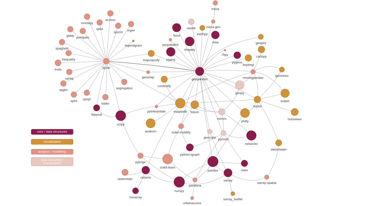
My first attempt to map the #GeoPython #PythonGIS ecosystem (currently n=69) for our pythongis project (vector+raster) ๐Ÿค“ ๐‡๐ž๐ฅ๐ฉ ๐ง๐ž๐ž๐๐ž๐: What packages do I miss? I'm sure there are plenty of interesting libraries escaping my radar ๐Ÿง GeoPandas The Python Spatial Analysis Library (PySAL) Xarray
My first attempt to map the #GeoPython #PythonGIS ecosystem (currently n=69) for our <a href="/pythongis/">pythongis</a> project (vector+raster) ๐Ÿค“ ๐‡๐ž๐ฅ๐ฉ ๐ง๐ž๐ž๐๐ž๐: What packages do I miss? I'm sure there are plenty of interesting libraries escaping my radar ๐Ÿง <a href="/geopandas/">GeoPandas</a> <a href="/pysal_devs/">The Python Spatial Analysis Library (PySAL)</a> <a href="/xarray_dev/">Xarray</a>
Henrikki Tenkanen ๐ŸŒ htenkanen.bsky.social (@tenkahen) 's Twitter Profile Photo

#2 attempt to map the #GeoPython #PythonGIS ecosystem for our pythongis project. Currently 123 libraries covering a broader spectrum of pkgs. Thanks a lot for everyone who answered the call and helped! ๐Ÿ™๐Ÿ˜Ž Will produce separate for vector+raster & interactive ones to play with.

#2 attempt to map the #GeoPython #PythonGIS ecosystem for our <a href="/pythongis/">pythongis</a> project. Currently 123 libraries covering a broader spectrum of pkgs. Thanks a lot for everyone who answered the call and helped! ๐Ÿ™๐Ÿ˜Ž Will produce separate for vector+raster &amp; interactive ones to play with.