LCPS GIS (@lcps_gis) 's Twitter Profile
LCPS GIS

@lcps_gis

Loudoun County Public Schools Geospatial Science program

ID: 2913847498

calendar_today10-12-2014 14:03:25

241 Tweet

119 Takipçi

86 Takip Edilen

josephkerski (@josephkerski) 's Twitter Profile Photo

1 year after the #mars lander you can still explore the planet with this 3D Mars mapping toolset and data! community.esri.com/t5/education-b…

josephkerski (@josephkerski) 's Twitter Profile Photo

Teaching and learning about geo-ethics with the Geoprivacy video series | Spatial Reserves. #ethics #gis ⁦Esri GIS Education⁩ spatialreserves.wordpress.com/2022/06/06/tea…

LCPS GIS (@lcps_gis) 's Twitter Profile Photo

Congratulations Ravin from Riverside High School project on Visualizing Space Debris and Predicting Future Collisions! 1st place winner for JMU's Annual GSS Map Contest! storymaps.arcgis.com/stories/311592… Esri GIS Education Geospatial Semester

Esri (@esri) 's Twitter Profile Photo

Our new Wildfire Aware app tracks #wildfires across the US and reports on their impacts to people, property, and the natural environment. 🔹Explore your community: esri.social/USbW50KKU8x

Esri Disaster Response Program (@esridrp) 's Twitter Profile Photo

We are monitoring #HurricaneIan. Find live maps and apps on the DRP #GIS resource Hub: esri.social/gk2V50KTrz1 and monitor status of our live data feeds here: esri.social/mNsj50KTrz3 To request assistance visit: esri.social/Ppvs50KTrz2 #EsriDRP #PublicSafety Esri

We are monitoring #HurricaneIan. Find live maps and apps on the DRP #GIS resource Hub: esri.social/gk2V50KTrz1  and monitor status of our live data feeds here: esri.social/mNsj50KTrz3 
To request assistance visit: esri.social/Ppvs50KTrz2 

#EsriDRP #PublicSafety <a href="/Esri/">Esri</a>
Esri (@esri) 's Twitter Profile Photo

As Earth’s temperatures rise, scientists predict an increase in the intensity of storms, like Hurricane Ian. Here's how they form, and how they affect the people and environments in their paths. esri.social/x0O350KYr2n

GIS Day (@gisday) 's Twitter Profile Photo

To whoever said, "the more things change, the more they stay the same," Landsat would like a word. Use this tool show to how remote sensing helps geographers detect change over time. 🛰 ow.ly/Zg6E50LsbE9

Esri (@esri) 's Twitter Profile Photo

Create an aspect-slope map in #ArcGISPro. This one of Crater Lake National Park illuminates the caldera walls that formed 7,700 years ago when the ancient volcano Mount Mazama collapsed. esri.social/c2TJ50MG6ef

Create an aspect-slope map in #ArcGISPro. This one of Crater Lake National Park illuminates the caldera walls that formed 7,700 years ago when the ancient volcano Mount Mazama collapsed. esri.social/c2TJ50MG6ef
Esri (@esri) 's Twitter Profile Photo

Heat maps are notoriously sensitive to scale. Here are four things you should consider when creating heat maps so they work across all scale levels. esri.social/qJyk50MIsqI #JavaScript

Esri (@esri) 's Twitter Profile Photo

For #EarthWeek, we're highlighting some standout organizations and people who are working tirelessly to create a more sustainable, livable, and just planet. 🌎 Join us as we celebrate these heroes. 🔹Animation by John Nelson

Esri (@esri) 's Twitter Profile Photo

To protect biodiversity, we first need to know where to start. NatureServe's Map of Biodiversity Importance (MoBI) shows the critical areas that are currently not protected. 🔸Explore the maps: esri.social/lw1T50NJLpg #EarthWeek
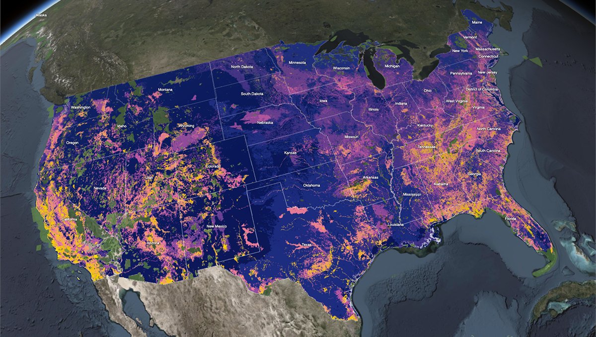
To protect biodiversity, we first need to know where to start. <a href="/natureserve/">NatureServe</a>'s Map of Biodiversity Importance (MoBI) shows the critical areas that are currently not protected. 

🔸Explore the maps: esri.social/lw1T50NJLpg #EarthWeek