Greg Cocks 🇺🇦 💧🗺️🌏🧭 (@gregcocks_kiwi) 's Twitter Profile Photo

#3D #Elevation [#3DEP] Data Crucial To Supporting The #Nation’s #Infrastructure And Maintaining #EconomicSecurity - usgs.gov/news/featured-… - #GIS #spatial #mapping #LiDAR #opendata #remotesensing #topography #economy #economicbenefits #pointcloud #IfSAR #datacollaboration USGS

#3D #Elevation [#3DEP] Data Crucial To Supporting The #Nation’s #Infrastructure And Maintaining #EconomicSecurity
-
usgs.gov/news/featured-…
-
#GIS #spatial #mapping #LiDAR #opendata #remotesensing #topography #economy #economicbenefits #pointcloud #IfSAR #datacollaboration
<a href="/USGS/">USGS</a>
Greg Cocks 🇺🇦 💧🗺️🌏🧭 (@gregcocks_kiwi) 's Twitter Profile Photo

Assessing #Landslide #Risk in #PrinceWilliamSound - usgs.gov/news/featured-… - #GIS #spatial #mapping #remotesensing #ifsar #elevation #engineeringgeology #massmovement #hazard #tsunami #climatechange #slopestability #coast #coastal #monitoring #geomorphology #geomorphometry USGS

Assessing #Landslide #Risk in #PrinceWilliamSound
-
usgs.gov/news/featured-…
-
#GIS #spatial #mapping #remotesensing #ifsar #elevation #engineeringgeology #massmovement #hazard #tsunami #climatechange #slopestability #coast #coastal #monitoring #geomorphology #geomorphometry
<a href="/USGS/">USGS</a>
İntikamMeleği (@karanliginkizi7) 's Twitter Profile Photo

#İFŞALAR #İFŞALAR #İFŞAR PAÇAYI KURTARMA DERDİ İLE #İTİRAFLAR #İTİRAFLAR #İTİRAFLAR 😉 DEMEK Kİ !? #KOKUYU ALANLAR da ! #SATIŞLAR BAŞLAMIŞ !? BÜLBÜLLER #ŞAKIMAYA BAŞLAMIŞ !😉 YAKINDA ! KORO HALİNDE PEŞ PEŞE #ÖTMELERDE BAŞLAYACACAK !?

Greg Cocks 🇺🇦 💧🗺️🌏🧭 (@gregcocks_kiwi) 's Twitter Profile Photo

Extensibility #UNet #NeuralNetwork #Model For #Hydrographic #FeatureExtraction & Implications #Hydrologic #Modeling doi.org/10.3390/rs1312… #GIS #spatial #mapping #ML #hydrology #remotesensing #topography #deeplearning #AI #ifSAR #elevation #ANN #HPC #DEM #opendata #3dep USGS

Extensibility #UNet #NeuralNetwork #Model For #Hydrographic #FeatureExtraction &amp; Implications #Hydrologic #Modeling

doi.org/10.3390/rs1312…

#GIS #spatial #mapping #ML #hydrology #remotesensing #topography #deeplearning #AI #ifSAR #elevation #ANN #HPC #DEM #opendata #3dep
<a href="/USGS/">USGS</a>
Greg Cocks 🇺🇦 💧🗺️🌏🧭 (@gregcocks_kiwi) 's Twitter Profile Photo

How #3DHydrography [#3DHP] Can Set The #Rivers Straight [#USGS] - geoweeknews.com/news/3d-hydrog… - #GIS #spatial #mapping #3D #EDH #hydrology #3dhp #elevation #3dep #lidar #ifsar #DEM #water #hydrology #nhd #nhdplushr #opendata #USA #waterresources #appliedscience #model #modeling USGS

How #3DHydrography [#3DHP] Can Set The #Rivers Straight [#USGS]
-
geoweeknews.com/news/3d-hydrog…
-
#GIS #spatial #mapping #3D #EDH #hydrology #3dhp #elevation #3dep #lidar #ifsar #DEM #water #hydrology #nhd #nhdplushr #opendata #USA #waterresources #appliedscience #model #modeling
<a href="/USGS/">USGS</a>
Greg Cocks 🇺🇦 💧🗺️🌏🧭 (@gregcocks_kiwi) 's Twitter Profile Photo

What Is The Difference Between #LiDAR Data And A Digital Elevation #Model (#DEM)? | What is #3DEP? - usgs.gov/faqs/what-diff… - usgs.gov/3d-elevation-p… - #GIS #spatial #mapping #opendata #spatialdata #USA #IfSAR #radar #digitalterrain #DTM #dataresources #pointcloud USGS

What Is The Difference Between #LiDAR Data And A Digital Elevation #Model (#DEM)? | What is #3DEP?
-
usgs.gov/faqs/what-diff…
-
usgs.gov/3d-elevation-p…
-
#GIS #spatial #mapping #opendata #spatialdata #USA #IfSAR #radar #digitalterrain #DTM #dataresources #pointcloud
<a href="/USGS/">USGS</a>
Greg Cocks 🇺🇦 💧🗺️🌏🧭 (@gregcocks_kiwi) 's Twitter Profile Photo

#Fluvial #Geomorphology Equivalent Of ‘Ontogeny Recapitulates Phylogeny’? usgs.gov/3d-elevation-p… #GIS #spatial #mapping #Alaska #USA #3DEP #opendata #elevation #iFSAR #remotesensing #hydrology #geology #landforms #appliedscience #arctic #arcticocean #beaufortsea #gischat USGS

#Fluvial #Geomorphology Equivalent Of ‘Ontogeny Recapitulates Phylogeny’?

usgs.gov/3d-elevation-p…

#GIS #spatial #mapping #Alaska #USA #3DEP #opendata #elevation #iFSAR #remotesensing #hydrology #geology #landforms #appliedscience #arctic #arcticocean #beaufortsea #gischat
<a href="/USGS/">USGS</a>
Greg Cocks 🇺🇦 💧🗺️🌏🧭 (@gregcocks_kiwi) 's Twitter Profile Photo

#Accuracy & #Consistency of #3DElevationProgram Data - A Systematic Analysis doi.org/10.3390/rs1404… #GIS #spatial #mapping #opendata #openaccess #elevation #DEM #LiDAR #IFSAR #CONUS #Alaska #dataaccess #metrics #precision #accuracyassessment #specifications #standards USGS

#Accuracy &amp; #Consistency of #3DElevationProgram Data - A Systematic Analysis

doi.org/10.3390/rs1404…

#GIS #spatial #mapping #opendata #openaccess #elevation #DEM #LiDAR #IFSAR #CONUS #Alaska #dataaccess #metrics #precision #accuracyassessment #specifications #standards
<a href="/USGS/">USGS</a>
Greg Cocks 🇺🇦 💧🗺️🌏🧭 (@gregcocks_kiwi) 's Twitter Profile Photo

What Is A #DigitalElevationModel (#DEM)?- A Practical #Guide equatorstudios.com/what-is-a-digi… #GIS #spatial #mapping #elevation #spatialdata #spatialanalysis #LiDAR #remotesensing #model #modeling #IFSAR #onlinelearning #tutorial #landform #bathymetry #geomorphology #geology #landforms

What Is A #DigitalElevationModel (#DEM)?- A Practical #Guide

equatorstudios.com/what-is-a-digi…

#GIS #spatial #mapping #elevation #spatialdata #spatialanalysis #LiDAR #remotesensing #model #modeling #IFSAR #onlinelearning #tutorial #landform #bathymetry #geomorphology #geology #landforms
Greg Cocks 🇺🇦 💧🗺️🌏🧭 (@gregcocks_kiwi) 's Twitter Profile Photo

I do get these #remotesensing acronyms, and LiDAR is even capitalised correctly... Thanks for the #CheatSheet Randall Munroe! ~looking up #IFSAR now~ xkcd.com/2759/ #GIS #spatial #mapping #mappymeme #gischat #lidar #sonar #laser #maser #sonar #radar

I do get these #remotesensing acronyms, and LiDAR is even capitalised correctly... Thanks for the #CheatSheet <a href="/xkcd/">Randall Munroe</a>! 
~looking up #IFSAR now~
xkcd.com/2759/
#GIS #spatial #mapping #mappymeme #gischat #lidar #sonar #laser #maser #sonar #radar
Greg Cocks 🇺🇦 💧🗺️🌏🧭 (@gregcocks_kiwi) 's Twitter Profile Photo

Christopher Beddow #3DEP #elevation program, for the #USA, excellent #LiDAR for CONUS (#ifsar for Alaska) as you can see in the map below, available free of charge and without use restrictions (and now in Google Earth too!) #opendata #GIS #spatial #mapping #gischat USGS usgs.gov/3d-elevation-p…

<a href="/cbed32/">Christopher Beddow</a> #3DEP #elevation program, for the #USA, excellent #LiDAR for CONUS (#ifsar for Alaska) as you can see in the map below, available free of charge and without use restrictions (and now in <a href="/googleearth/">Google Earth</a> too!)
#opendata #GIS #spatial #mapping #gischat <a href="/USGS/">USGS</a> 
usgs.gov/3d-elevation-p…
Greg Cocks 🇺🇦 💧🗺️🌏🧭 (@gregcocks_kiwi) 's Twitter Profile Photo

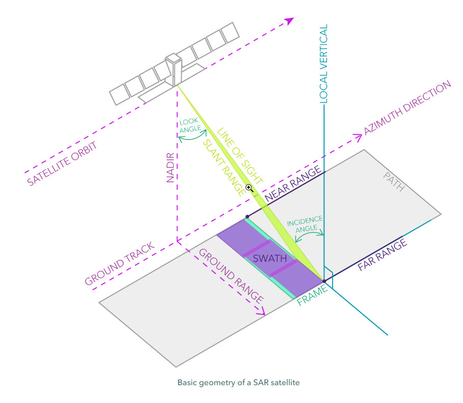
Guide - Fundamentals Of Synthetic Aperture Radar (SAR) - storymaps.arcgis.com/stories/20d8cd… - #GIS #spatial #mapping #remotesensing #satellite #SAR #ifSAR #guide #gischat #radar #syntheticapertureradar #earthobservation #sensor #explaination

Guide - Fundamentals Of Synthetic Aperture Radar (SAR)
-
storymaps.arcgis.com/stories/20d8cd…
-
#GIS #spatial #mapping #remotesensing #satellite #SAR #ifSAR #guide #gischat #radar #syntheticapertureradar #earthobservation #sensor #explaination
Greg Cocks 🇺🇦 💧🗺️🌏🧭 (@gregcocks_kiwi) 's Twitter Profile Photo

Helping put together some #iFSAR #elevation data for hydrologic analyses in a HUC8 in #Alaska... -- usgs.gov/3d-elevation-p… -- #GIS #spatial #mapping #remotesensing #USA #water #hydrology #3DEP #NHD #NHDPlusHR #water #spatialanalysis #opendata #datasets #glacial #gischat USGS

Helping put together some #iFSAR #elevation data for hydrologic analyses in a HUC8 in #Alaska...
--
usgs.gov/3d-elevation-p…
--
 #GIS #spatial #mapping #remotesensing #USA #water #hydrology #3DEP #NHD #NHDPlusHR #water #spatialanalysis #opendata #datasets #glacial #gischat
<a href="/USGS/">USGS</a>
DBAE UPM (@dbae_upm) 's Twitter Profile Photo

SFTRC article of the week (4/2023) #SmartFarming #erosioninducedlandslidesusceptibilitymap #datafusionDEM #ifsar #lidar #AgriculturalEngineering @ Faculty of Engineering, Universiti Putra Malaysia instagram.com/p/CoBUYIfPx52/…

Greg Cocks 🇺🇦 💧🗺️🌏🧭 (@gregcocks_kiwi) 's Twitter Profile Photo

3DEP 1m DEMs Now Available In Google Earth Engine developers.google.com/earth-engine/d… usgs.gov/3d-elevation-p… #GIS #spatial #mapping #opendata #USA #elevation #3DEP #GoogleEarthEngine #DEMs #remotesensing #LiDAR #ifSAR #bareearth #spatialanalysis USGS Google Google Earth Made by Google

3DEP 1m DEMs Now Available In Google Earth Engine
developers.google.com/earth-engine/d…  
usgs.gov/3d-elevation-p…  
#GIS #spatial #mapping #opendata #USA #elevation #3DEP #GoogleEarthEngine #DEMs #remotesensing #LiDAR #ifSAR #bareearth #spatialanalysis 
<a href="/USGS/">USGS</a> <a href="/Google/">Google</a> <a href="/googleearth/">Google Earth</a> <a href="/madebygoogle/">Made by Google</a>
Dewberry (@thedewberryway) 's Twitter Profile Photo

Al Karlin describes our work with the Southwest Florida Water Management District to construct digital elevation models to support updating hydrologic and hydraulic models for the Withlacoochee River: dewberry.com/insights-news/… #geospatial #lidar #data #3DEP #IfSAR #technology

Al Karlin describes our work with the Southwest Florida Water Management District to construct digital elevation models to support updating hydrologic and hydraulic models for the Withlacoochee River: 
dewberry.com/insights-news/…
#geospatial #lidar #data #3DEP #IfSAR #technology
Woolpert (@woolpert) 's Twitter Profile Photo

“We need this information to combat the effects of natural disasters that come with climate change and to protect the quality and availability of our water supply as the Earth evolves." USGS #mapping #lidar #ifsar #EDH #hydrography #geospatial #climate woolpert.com/news/press-rel…