Mukunya Arthur Andersen(@andy_kanshe) 's Twitter Profile Photo

Leveraging the power of sports for disaster response management and remote mapping! Kudos to OpenStreetMap Uganda for their efforts in promoting through sports in and . Let's map out a better future together! 🏞️⚽️

Leveraging the power of sports for disaster response management and remote mapping! Kudos to @osmuganda for their efforts in promoting #CommunityEngagement through sports in #GIS #QGIS and #disasterresponse. Let's map out a better future together! 🏞️⚽️ #SportsForChange #MapItOut
account_circle
David Abernathy(@dabernathy) 's Twitter Profile Photo

Just published an article (open access, of course) on teaching GIS with software, , , and open pedagogy. onlinelibrary.wiley.com/doi/full/10.11…

account_circle
ぴっかりん(@ra0kley) 's Twitter Profile Photo

Microsoftが公開している建物フットプリントをダウンロードして、幕張周辺をQGISで表示させてみた。
(背景地図はOpenStreetMap)
高解像度の光学衛星画像からのAI判読だから、きちんと形状に合っていなかったり、細かい建物が検出できていなかったりするな。

Microsoftが公開している建物フットプリントをダウンロードして、幕張周辺をQGISで表示させてみた。
(背景地図はOpenStreetMap)
高解像度の光学衛星画像からのAI判読だから、きちんと形状に合っていなかったり、細かい建物が検出できていなかったりするな。
account_circle
ぴっかりん(@ra0kley) 's Twitter Profile Photo

MicrosoftがODbLライセンスで公開している建物フットプリント、欧米を中心に高さ属性を追加データ公開されているし、2Dだけど日本の建物フットプリントも公開しているじゃん!!

blogs.bing.com/maps/2023-06/B…

account_circle
svg(@newgeographer2) 's Twitter Profile Photo

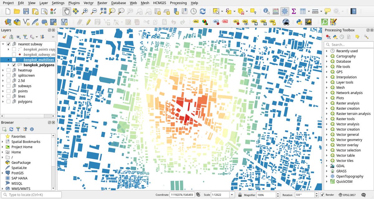
Globalmaptiles How to color by distance to multiple points with an aggregate function in :

ramp_color('YlOrRd',scale_linear(distance(aggregate(layer:='bangkok_subway_stations',aggregate:='collect',expression:=$geometry),$geometry),0,500,1,0))

@globalmaptiles How to color by distance to multiple points with an aggregate function in #qgis:

ramp_color('YlOrRd',scale_linear(distance(aggregate(layer:='bangkok_subway_stations',aggregate:='collect',expression:=$geometry),$geometry),0,500,1,0))
account_circle
Mudasar Hussain(@Mudasar41511381) 's Twitter Profile Photo

🌍 Exploring Pakistan's Geology with GIS 🗺️
I am thrilled to share with you a geological map of Pakistan that I created using QGIS, a powerful geographic information system (GIS) tool. This map showcases the fascinating geological formations that make up this beautiful country.

🌍 Exploring Pakistan's Geology with GIS 🗺️
I am thrilled to share with you a geological map of Pakistan that I created using QGIS, a powerful geographic information system (GIS) tool. This map showcases the fascinating geological formations that make up this beautiful country.
account_circle