
#LaPalmaEruption 🌋
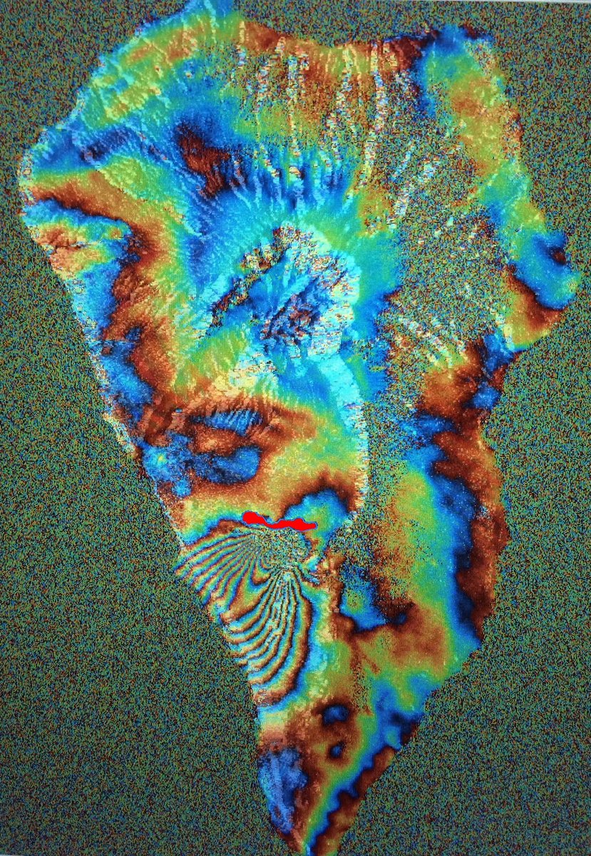
Signal of soil deformation in the fissure eruption of #CumbreVieja
Using data from the #Interferogram of the #Sentinel1 of Нет войне - Pablo J. González from September 14 and 20 and the data of Copernicus EMS of the affected area (red), it results in this map
#EMSR546

1⃣ Aerial view: #lava flows destroying banana plantations by the coast of #LaPalma #CanaryIslands
2⃣ Copernicus EMS updates #EMSR546 as of 19 October: extent of the lava flow: 866.1 ha / 2185 destroyed buildings
🌋 #CumbreVieja #VolcandeLaPalma
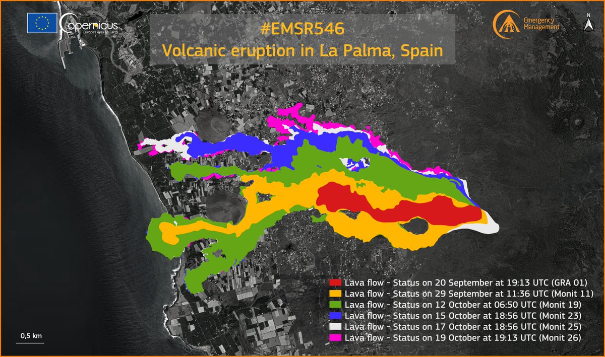

Joan Anton Català Amigó El suplement Catalunya Ràdio M'encantaria que expliquessis perquè no som capaços de fer mapes de l'evolució de la lava a temps real (no dia a dia com fa #EMSR546 ) que servirien per combatre #fakenews com aquesta youtube.com/watch?v=GijD5f…

[13/11/2021 18:44] Secuencia completa del crecimiento de la colada de lava, con datos de Copernicus EMS #EMSR546 , hasta ayer día 13 de noviembre a las 18:44.
#VigilanciaLaPalma #ErupciónLaPalma #VolcandeLaPalma #LaPalma

Updates from #LaPalma : Copernicus EMS has released an updated product #EMSR546 showing an area of 497 ha covered by the #lava flow
1,186 buildings destroyed (since the beginning of the eruption)
🌋Posting here also map by Iban Ameztoy for a regional overview of #LaPalma Eruption
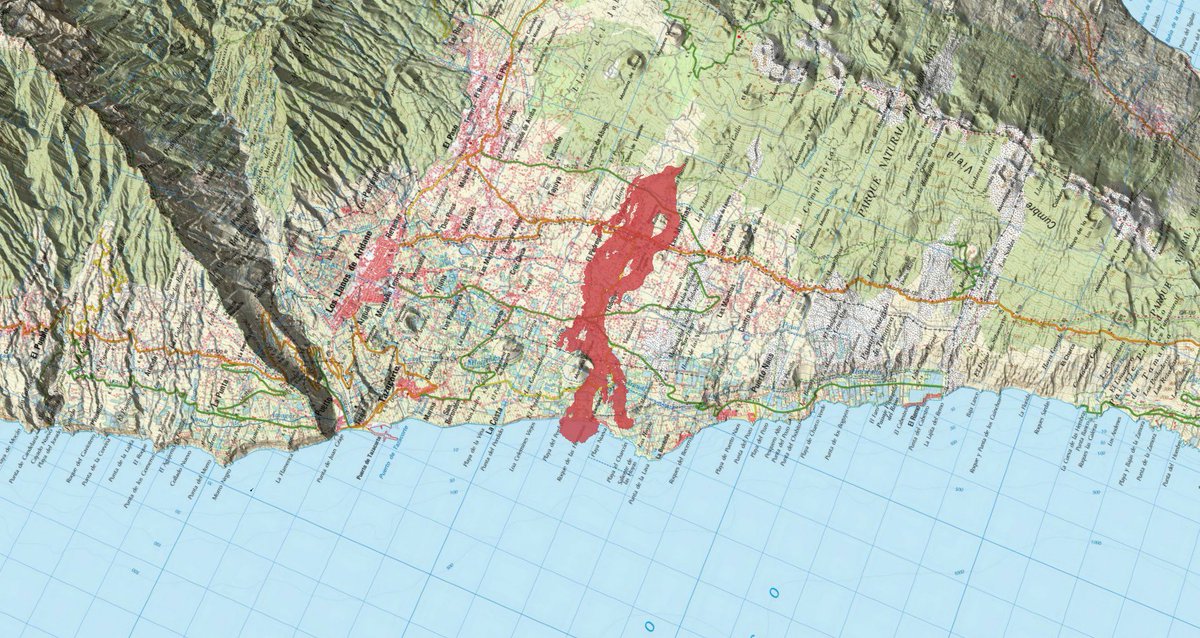
RT Copernicus EMS: #EMSR546 #ErupciónLaPalma #CumbreVieja
Our #RapidMappingTeam has released its 4⃣2⃣nd updated map
It is based on Airbus Space
As of 2 November at 12:13 UTC:
▶️Extent of the lava flow: 997.9 ha (+10.0 ha in ~17h)
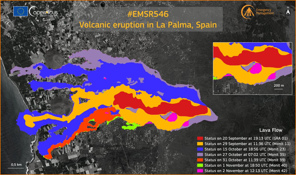

Copernicus EMS Instituto Geográfico Nacional-O.A.CNIG GRAFCAN Actualizo la animación con la evolución de la colada de lava, a las 20:44 de ayer día 23, según #EMSR546 .
Ocupa ya una superficie de 190.7 hectáreas, destruyendo 420 construcciones y dañando posiblemente a otras 32.
#erupcionlapalma #VolcandeLaPalma #LaPalma

3D virtual flight taking images of today's drone
🌋 #ErupciónLaPalma .
It has affected 849🏡
2122 buildings destroyed according to data from 🇪🇺 @ CopernicusEMS ( #EMSR546 )
ℹ️🔗https: //t.co/FYsNrTHx4y
#LaPalma #CumbreVieja #CanaryIslands #Canarias #GranCanaria #LaPalma volcan

Google Maps According to Copernicus ZIP file, the point of eruption is located at: $ cat EMSR546_AOI01_GRA_PRODUCT_observedEventP_r1_v1.json: [ -17.867643, 28.614819 ] emergency.copernicus.eu/mapping/downlo…


[11/13/2021 18:44] Complete sequence of lava flow growth, with data from Copernicus EMS
# EMSR546, until yesterday, November 13 at 18:44.
Raphael Grandin Alistair Hamill Those magnificent images ( there are many more of them ) are from COSMO-SkyMed satellites and they are attached to Copernicus EMS reports. You can find them under #EMSR546 tag. Here's one of reports as an example. Click the link and then click 200 dpi jpeg emergency.copernicus.eu/mapping/ems-pr…

#EMSR546 #ErupciónLaPalma
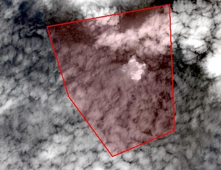
Today’s acquisition of optical imagery was again unfortunately very cloudy…
therefore proceeding with the production of 2️⃣6️⃣th updated mapping product using, for the
first time ever, radar imagery from the PAZ 🇪🇸 satellite
#LaPalma #CumbreVieja

10/09/2021] Complete sequence of lava flow growth, with data from #EMS #EMS R546, until October 8th.
#erupcionlapalma #VolcandeLaPalma #LaPalma #CumbreVieja #CanaryIslands #Canarias #GranCanaria #LaPalma volcan #volcan CumbreVieja #España #Spain #volcan o #volcan #lava

#EMSR546 #ErupciónLaPalma
Our #RapidMappingTeam released its 11th updated product for #LaPalma 🇪🇸🌋 using a Very High Resolution 🛰️image
855 destroyed 🏘️ have been detected, 201 more in 28 hours ‼️
A new VHR image will be acquired today at 12:14 UTC
alertamundialrt.info/2021/10/la-isl…


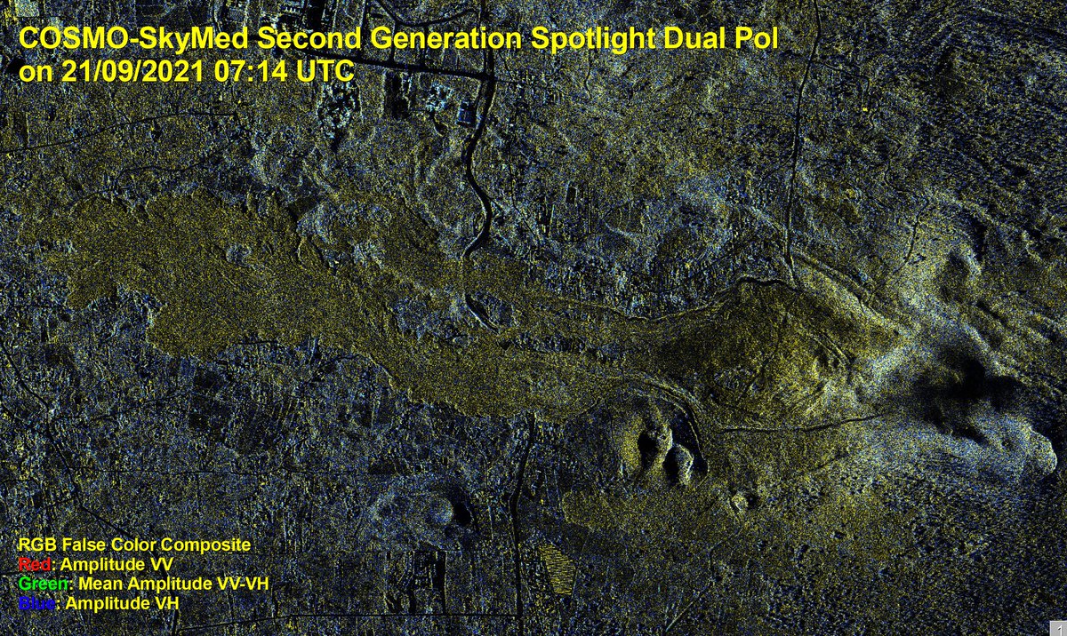
The Italian #CosmoSkyMED #SecondGeneration (Agenzia Spaziale ITA/Ministero Difesa) radar satellite, thanks to its dual polarization, has provided images to support Copernicus EMS #RapidMappingTeam , coordinated by e-GEOS, to generate maps of the eruption on the island of #LaPalma #EMSR546


Yesterday, the Italian #COSMOSkyMed -Second Generation radar satellite (Agenzia Spaziale ITA/Ministero Difesa) captured for Copernicus EMS #EMSR546 #VeryHighResolution #DualPol image of the #ErupciónLaPalma , showing how the lava front has advanced by 330 metres in just a few hours.

EU_ScienceHub Instituto Geográfico Nacional-O.A.CNIG DSN INVOLCAN EU Civil Protection & Humanitarian Aid 🇪🇺 Presidencia GobCan DG Protección Civil y Emergencias. España From this image it is possible to see where the lava is and where most probably will fall into the sea @Lapalma DSN INVOLCAN EU Civil Protection & Humanitarian Aid 🇪🇺 Presidencia GobCan DG Protección Civil y Emergencias. España #EMSR546


🗺 Nuevo mapa: [# EMSR546] #LaPalma Programa #Copernicus . #Erupción 🌋 #CabezaDeVaca #CumbreVieja #ElPaso
👇🔗 j.mp/3zNdCnm
![Verónica Castro (@castropveronica) on Twitter photo 2021-09-25 17:43:20 🗺 Nuevo mapa: [# EMSR546] #LaPalma Programa #Copernicus. #Erupción🌋 #CabezaDeVaca #CumbreVieja #ElPaso
👇🔗 j.mp/3zNdCnm 🗺 Nuevo mapa: [# EMSR546] #LaPalma Programa #Copernicus. #Erupción🌋 #CabezaDeVaca #CumbreVieja #ElPaso
👇🔗 j.mp/3zNdCnm](https://pbs.twimg.com/media/FAJgOHmVcAAz6-H.jpg)


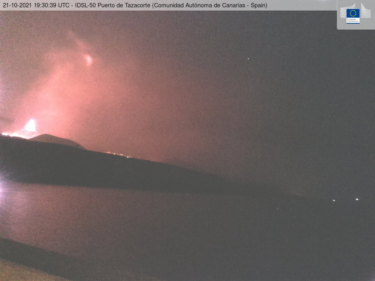
JRC EU_ScienceHub and Instituto Geográfico Nacional-O.A.CNIG installed the IDSL-50 at #LaPalma 👏 This device will allow to monitor the sea level at #CumbreViejaVolcano . A live webcam provides a view of the volcano sea area. webcritech.jrc.ec.europa.eu/TAD_server/Dev…
DSN INVOLCAN EU Civil Protection & Humanitarian Aid 🇪🇺 Presidencia GobCan DG Protección Civil y Emergencias. España #EMSR546
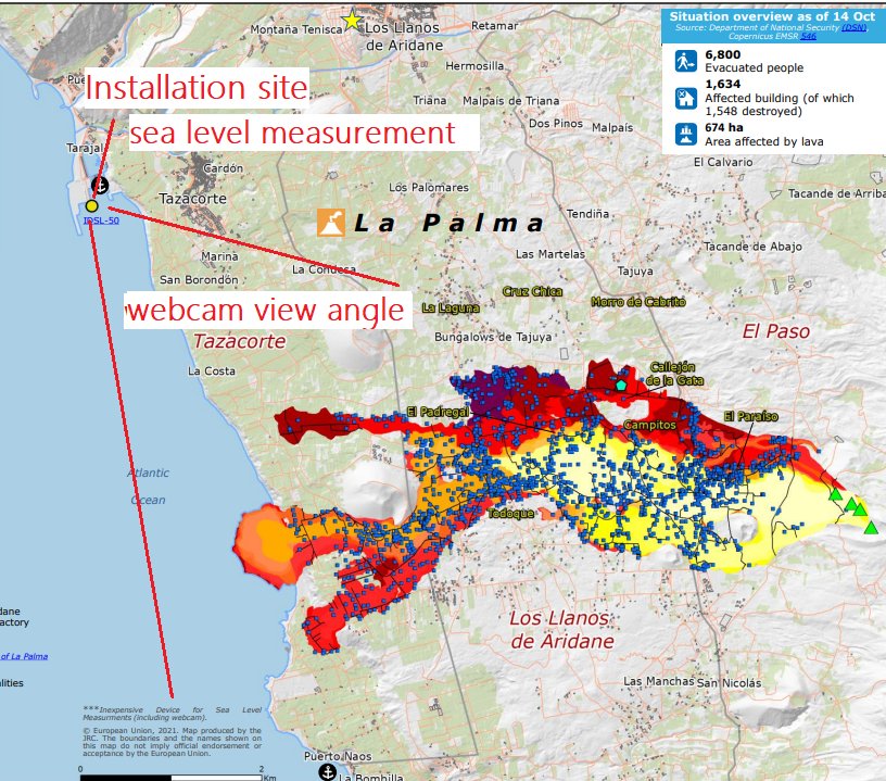
![Isabel Caballero de Frutos (@ICaballero28) on Twitter photo 2021-10-15 13:31:18 ℹ️Copernicus Emergency Management Service in #LaPalma 🌋🛰️
▶️[EMSR546] La Palma: Grading Product, Monitoring 21.
🗓️Published: 2021-10-15 12:24 (UTC) ℹ️Copernicus Emergency Management Service in #LaPalma 🌋🛰️
▶️[EMSR546] La Palma: Grading Product, Monitoring 21.
🗓️Published: 2021-10-15 12:24 (UTC)](https://pbs.twimg.com/media/FBvlmrbXsAETlHM.jpg)
![The Blessed Cat Daddy (@RandyWendt9) on Twitter photo 2021-10-06 04:35:00 [EMSR546] La Palma: Grading Product, Monitoring 14, version 2, release 1, RTP Map #01 [EMSR546] La Palma: Grading Product, Monitoring 14, version 2, release 1, RTP Map #01](https://pbs.twimg.com/media/FA_VIGnVgAgkvTe.jpg)