Tobias Hennemuth 🔥🌳🌲 (@t_hennemuth) 's Twitter Profile
Tobias Hennemuth 🔥🌳🌲

@t_hennemuth

#Firefighter, Waldbrandbekämpfer 🔥 Naturliebhaber und bergverliebt. Gerne vorbereitet. Mag den 🌳🌲und liebt seine 👩‍👧‍👧. #klimasoldat

ID: 756666369299648512

calendar_today23-07-2016 01:44:55

1,1K Tweet

565 Takipçi

2,2K Takip Edilen

FireMap.live 🔥🌎 (@disaster_db) 's Twitter Profile Photo

LA Fires in Satellite Images🛰️🧵 #EatonFire had already done horrific damage and many homes in smoldering ruins. The satellite photo below, taken over Marathon Road in Altadena, shows near-total devastation of homes on Wednesday. 📸 Image Source: MAXAR

LA Fires in Satellite Images🛰️🧵

#EatonFire  had already done horrific damage and many homes in smoldering ruins. The satellite photo below, taken over Marathon Road in Altadena, shows near-total devastation of homes on Wednesday.
📸 Image Source: MAXAR
Pau Costa Foundation (@paucostaf) 's Twitter Profile Photo

📢 Registration is open for the "Fire Weather Training"🔥to create basic weather forecasts, translate them into fire behaviour, and better understand more specialised analyses of meteorological information for wildfires. The deadline for registering is February 10 ⏳ 📅 March

📢 Registration is open for the "Fire Weather Training"🔥to create basic weather forecasts,  translate them into fire behaviour, and better understand more specialised analyses of meteorological information for wildfires. The deadline for registering is February 10 ⏳ 

📅 March
Copernicus EU (@copernicuseu) 's Twitter Profile Photo

A fast-moving fire broke out in the Hollywood Hills of California, USA, on 7 January 2025, threatening iconic Los Angeles landmarks and thousands of homes. Wildfires burning in Los Angeles are visible in this #Sentinel3 image acquired on 9 January 2025. copernicus.eu/en/media/image…

A fast-moving fire broke out in the Hollywood Hills of California, USA, on 7 January 2025, threatening iconic Los Angeles landmarks and thousands of homes. 

Wildfires burning in Los Angeles are visible in this #Sentinel3 image acquired on 9 January 2025.

copernicus.eu/en/media/image…
Pau Costa Foundation (@paucostaf) 's Twitter Profile Photo

Los múltiples incendios del sur de California 🔥están afectando una zona densamente poblada ubicada en la interfaz urbano-forestal 🏡Y hay que enfatizar que es importante que la sociedad tenga conciencia de los riesgos que comporta vivir en zonas próximas a masas forestales para

Los múltiples incendios del sur de California 🔥están afectando una zona densamente poblada ubicada en la interfaz urbano-forestal 🏡Y hay que enfatizar que es importante que la sociedad tenga conciencia de los riesgos que comporta vivir en zonas próximas a masas forestales para
Copernicus EMS (@copernicusems) 's Twitter Profile Photo

🔥#Wildfires continue to blaze in #California. According to #GWIS, the fire danger forecast for the next 24 hours across southern #California ranges from🟠very high to 🔴extreme. More details 👇 gwis.jrc.ec.europa.eu/apps/gwis_curr…

🔥#Wildfires continue to blaze in #California.

According to #GWIS, the fire danger forecast for the next 24 hours across southern #California ranges from🟠very high to 🔴extreme.

More details 👇
gwis.jrc.ec.europa.eu/apps/gwis_curr…
ESA Earth Observation (@esa_eo) 's Twitter Profile Photo

A new image showing the extent of the fires in California. Copernicus EU Sentinel-3 🛰️captured this view on 9 January: on the lower left of the image we can see the Palisades fire and on the top right is the Eaton fire - with smoke seen reaching Catalina Island and the Santa

A new image showing the extent of the fires in California.

<a href="/CopernicusEU/">Copernicus EU</a> Sentinel-3 🛰️captured this view on 9 January: on the lower left of the image we can see the Palisades fire and on the top right is the Eaton fire - with smoke seen reaching Catalina Island and the Santa
CAL FIRE (@cal_fire) 's Twitter Profile Photo

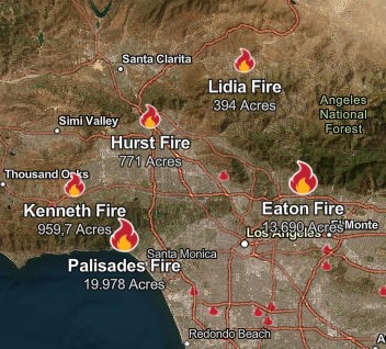
🔥Incident Updates (1/11/2025 PM) #EatonFire * North Pasadena and Altadena (LA County) * 14,117 acres, 15% contained fire.ca.gov/incidents/2025… #PalisadesFire * Pacific Palisades (LA County) * 23,654 acres, 11% contained fire.ca.gov/incidents/2025… #KennethFire * West Hills Area (LA

🔥Incident Updates (1/11/2025 PM)
#EatonFire
* North Pasadena and Altadena  (LA County)
* 14,117 acres, 15% contained
fire.ca.gov/incidents/2025…

#PalisadesFire
* Pacific Palisades (LA County)
* 23,654 acres, 11% contained
fire.ca.gov/incidents/2025…

#KennethFire
* West Hills Area (LA
FireMap.live 🔥🌎 (@disaster_db) 's Twitter Profile Photo

🚨 Interesting Data on AutoFire from Landsat 8 12 hours ago, our FireDB system detected 2 heat signatures at the River Ridge Golf Course using Landsat 8 satellite. These heat signatures suggest the presence of an electrical facility emitting significant heat, which Landsat 8

🚨 Interesting Data on AutoFire from Landsat 8 

12 hours ago, our FireDB system detected 2 heat signatures at the River Ridge Golf Course using Landsat 8 satellite. These heat signatures suggest the presence of an electrical facility emitting significant heat, which Landsat 8
Zeke Lunder ~ The Lookout (@wildland_zko) 's Twitter Profile Photo

Here is a Lookout post about the progression of the Palisades Fire. It has a link to the livestream video on the topic, a progression map, and a narrative about how the fire spread. We don't speculate on fire causes in general... the-lookout.org/2025/01/21/pro…

FirePhotoGirl (@firephotogirl) 's Twitter Profile Photo

Over 5k acres and it doesn’t seem to be slowing down one bit! Headed around the lake and pushing towards the 5 freeway. #lakehughesfire #breaking Shot from Lake Hughes Rd

Zeke Lunder ~ The Lookout (@wildland_zko) 's Twitter Profile Photo

The #HughesFire is burning in one of the most fire-prone landscapes in the United States. Hughes Fire shown in red. Outside of Hughes Fire, since 1930s: Blue areas have burned 1-2 times, Green 3-4, Orange 5-6, Red, 7 or more. #FireHistory

The #HughesFire is burning in one of the most fire-prone landscapes in the United States. 
Hughes Fire shown in red.
Outside of Hughes Fire, since 1930s:
Blue areas have burned 1-2 times, 
Green 3-4, 
Orange 5-6, 
Red, 7 or more.
#FireHistory
Kachelmannwetter (@kachelmannwettr) 's Twitter Profile Photo

Extreme "Wärme" derzeit im Nordpolarmeer (Arktik) mit einer Temperaturabweichung von 20 bis 25 Grad über dem Klimamittel. /LD kachelmannwetter.com/de/modellkarte…

The Hotshot Wake Up (@hotshotwake) 's Twitter Profile Photo

Insane footage from South Carolina last night. Crews say they were able to save these homes just outside The Reserve at Walkers Woods. The fire is estimated to be 1,200+ acres now. Aviation is overhead working the fire this morning.

The Hotshot Wake Up (@hotshotwake) 's Twitter Profile Photo

New York: A very large and fast moving fire has broken out on Long Island in the Hamptons. A huge response is underway. There are reports of a mile long front as it pushes across the landscape. Winds are reported at 35MPH and relative humidities in the low 20th percentile.

New York: A very large and fast moving fire has broken out on Long Island in the Hamptons. A huge response is underway. There are reports of a mile long front as it pushes across the landscape. 

Winds are reported at 35MPH and relative humidities in the low 20th percentile.
The Hotshot Wake Up (@hotshotwake) 's Twitter Profile Photo

More views of the wildfire ripping across Long Island, New York. Fire resources from across the state are responding to the fire near the Hamptons. The column can be seen in Connecticut and aviation is overhead. Current temps are 42 degrees with sustained winds pushing 30MPH+.

The Hotshot Wake Up (@hotshotwake) 's Twitter Profile Photo

The view from Manorville Fire Department punching into one of the fires burning on Long Island, New York. Solid work, looks like a fun rig you folks got there, good luck! 📷: Via Emeka Gift Official