S. Sunako (@sunako_s) 's Twitter Profile
S. Sunako

@sunako_s

PostDoc in Snow and Ice Research Center, NIED, Japan. Studying glaciers in the Himalayas.
researchmap.jp/ssunako?lang=en

ID: 3061515247

calendar_today04-03-2015 14:29:07

234 Tweet

84 Followers

158 Following

S. Sunako (@sunako_s) 's Twitter Profile Photo

服部文祥さんの「息子と狩猟に」を購入したが、収録されている「K2」が傑作だった (表題作も勿論良作)。 さて、今から晩飯食べる…かな…

S. Sunako (@sunako_s) 's Twitter Profile Photo

これまでレインスーツには頑固なネパール臭が染みついていたのに、この前観測点に行ってからは獣の糞尿臭 (猪?)も新たに加わった 。 加わったというか、もうホントにただ臭いだけなので買い替えようと思う。お役御免。

The Cryosphere (@egu_tc) 's Twitter Profile Photo

New research article: Surface composition of debris-covered glaciers across the Himalaya using linear spectral unmixing of Landsat 8 OLI imagery doi.org/10.5194/tc-15-…

ライブドアニュース (@livedoornews) 's Twitter Profile Photo

1000RT:【噴石などに注意を】熊本・阿蘇山が噴火 news.livedoor.com/article/detail… 午前11時43分ごろに噴火が発生。阿蘇山の噴火警戒レベルはレベル2(火口周辺規制)からレベル3(入山規制)に引き上げられた。

1000RT:【噴石などに注意を】熊本・阿蘇山が噴火
news.livedoor.com/article/detail…

午前11時43分ごろに噴火が発生。阿蘇山の噴火警戒レベルはレベル2(火口周辺規制)からレベル3(入山規制)に引き上げられた。
Mukesh Rai (@mukeshraee) 's Twitter Profile Photo

Our paper is just published in #AGUpubs Here we reflect on the black carbon (BC) transport mechanism, synergy on BC - boundary layer feedback, and radiative perturbation over the Pan-Third Pole. Access 👇 agupubs.onlinelibrary.wiley.com/doi/10.1029/20… Great shout out to Matplotlib.

Our paper is just published in  #AGUpubs
Here we reflect on the black carbon (BC) transport mechanism, synergy on BC - boundary layer feedback, and radiative perturbation over the Pan-Third Pole.
Access 👇
agupubs.onlinelibrary.wiley.com/doi/10.1029/20…
Great shout out to <a href="/matplotlib/">Matplotlib</a>.
S. Sunako (@sunako_s) 's Twitter Profile Photo

昨日グリーンランドから帰国。犬橇事始は長岡の本屋に置いてなかった。イラク水滸伝は無事購入。

国土地理院 (@gsi_chiriin) 's Twitter Profile Photo

【リリース】 高解像度の地形データの提供を開始します 最新の航空レーザ測量データを基に作成した #基盤地図情報(数値標高モデル)1mメッシュ(標高)の提供を11月30日(木)に開始します。HPでサンプルデータ公開中 ▼詳しくはこちら gsi.go.jp/gazochosa/gazo…

雪氷研究室/Cryosphere Research Lab, Nagoya Univ. (@hma_glaciers) 's Twitter Profile Photo

Wall Camp(標高5,060m)でのタイムラプス(2023/10/30)。 岩屑に覆われたトラカルディン氷河を見下ろし、奥には氷河湖が見えます。 朝6時半頃から夕方17時頃まで撮影しました。 月の入りから、徐々に日が昇って雲が湧き上がってくる様子が見られます。 #NU_Rolwaling2023

防災科学技術研究所(防災科研) (@c2010nied) 's Twitter Profile Photo

【能登半島地震雪氷災害関連情報の特設ページを公開】 ・防災科研雪氷防災研究センター調査報告(速報) ・さらなる土砂災害や雪崩に注意 ・屋根雪に注意 ・中越地震後の大雪で発生した関連災害の報告書 など、今後順次更新する予定です。 参考にしていただければ幸いです。 bosai.go.jp/seppyo/disaste…

Int. Glaciol. Soc. (@igsoc) 's Twitter Profile Photo

New paper in AoG! A novel method to visualize liquid distribution in snow: superimposition of MRI and X-ray CT images, by Satoru Yamaguchi, Satoru Adachi, and Sojiro Sunako. #microstructure #grainsize doi.org/10.1017/aog.20…

New paper in AoG! A novel method to visualize liquid distribution in snow: superimposition of MRI and X-ray CT images, by Satoru Yamaguchi, Satoru Adachi, and Sojiro Sunako. #microstructure #grainsize doi.org/10.1017/aog.20…
Arun B Shrestha (@arunbshrestha) 's Twitter Profile Photo

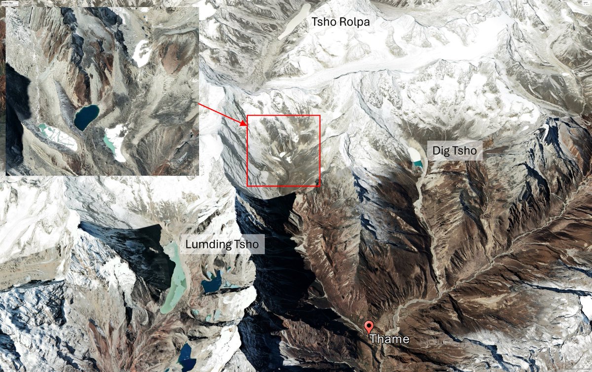
Devastating flood hit #Thame village likely caused by a lake outburst near Tashi Lapcha Pass. This is a harsh reminder of the realities of climate change, echoing the 1985 #DigTsho #GLOF that destroyed Thame Hydropower. Thoughts and prayers #ClimateChange #ClimateActionNow

Devastating flood hit #Thame  village likely caused by a lake outburst near Tashi Lapcha Pass. This is a harsh reminder of the realities of climate change, echoing the 1985 #DigTsho #GLOF that destroyed Thame Hydropower. 
Thoughts and prayers
#ClimateChange #ClimateActionNow
Kabir Uddin (@kabir_uddin1) 's Twitter Profile Photo

The flooded Thame River visualized through a virtual GIS (ArcGIS) flood inundation map generated using Planet Lab imagery and building data from OpenStreetMap. #GIS #FloodMapping #PlanetLab #OpenStreetMap

The Cryosphere (@egu_tc) 's Twitter Profile Photo

New article: Brief communication: Accurate and autonomous snow water equivalent measurements using a cosmic ray sensor on a Himalayan glacier doi.org/10.5194/tc-18-…

道路開通情報 (@road_open) 's Twitter Profile Photo

✕の橋が雪崩で流失。以前には黄色のところの橋も雪崩で流失している。残骸らしきものが航空写真に。 国道252号(只見町大字田子倉地内)の「出逢橋」の流失について pref.fukushima.lg.jp/sec/41360a/hou…

✕の橋が雪崩で流失。以前には黄色のところの橋も雪崩で流失している。残骸らしきものが航空写真に。

国道252号(只見町大字田子倉地内)の「出逢橋」の流失について
pref.fukushima.lg.jp/sec/41360a/hou…