Spring Hill Weather (@springhillwx) 's Twitter Profile
Spring Hill Weather

@springhillwx

I'm Sheila Durham. Advanced Storm Spotter-middle TN. Not a Meteorologist. Not affiliated with any media or weather agencies. This is a privately owned page.

ID: 781024566

linkhttp://www.facebook.com/shweather calendar_today25-08-2012 20:23:53

4,4K Tweet

1,1K Takipçi

201 Takip Edilen

NWS Nashville (@nwsnashville) 's Twitter Profile Photo

A severe thunderstorm watch has been issued for parts of Arkansas, Illinois, Indiana, Kentucky, Missouri and Tennessee until 9 AM CDT

A severe thunderstorm watch has been issued for parts of Arkansas, Illinois, Indiana, Kentucky, Missouri and Tennessee until 9 AM CDT
Spring Hill Weather (@springhillwx) 's Twitter Profile Photo

I enjoyed visiting the Spring Hill Police this week, and I brought snacks! We are so grateful for our men & women behind the badge! #NationalPoliceWeek #BackTheBlue

I enjoyed visiting the <a href="/SHPDTN/">Spring Hill Police</a> this week, and I brought snacks! We are so grateful for our men &amp; women behind the badge! #NationalPoliceWeek #BackTheBlue
NashSevereWx (@nashseverewx) 's Twitter Profile Photo

Current Thinking: The cluster of storms along the MS River will grow southward into AR and form a line. That line will be our storms 10-midnite. The atmosphere is charged. IF (big IF) an isolated cell can form ahead of the line, it would likely be severe with wind, hail, tornado

Current Thinking: The cluster of storms along the MS River will grow southward into AR and form a line. That line will be our storms 10-midnite. The atmosphere is charged. IF (big IF) an isolated cell can form ahead of the line, it would likely be severe with wind, hail, tornado
NWS Nashville (@nwsnashville) 's Twitter Profile Photo

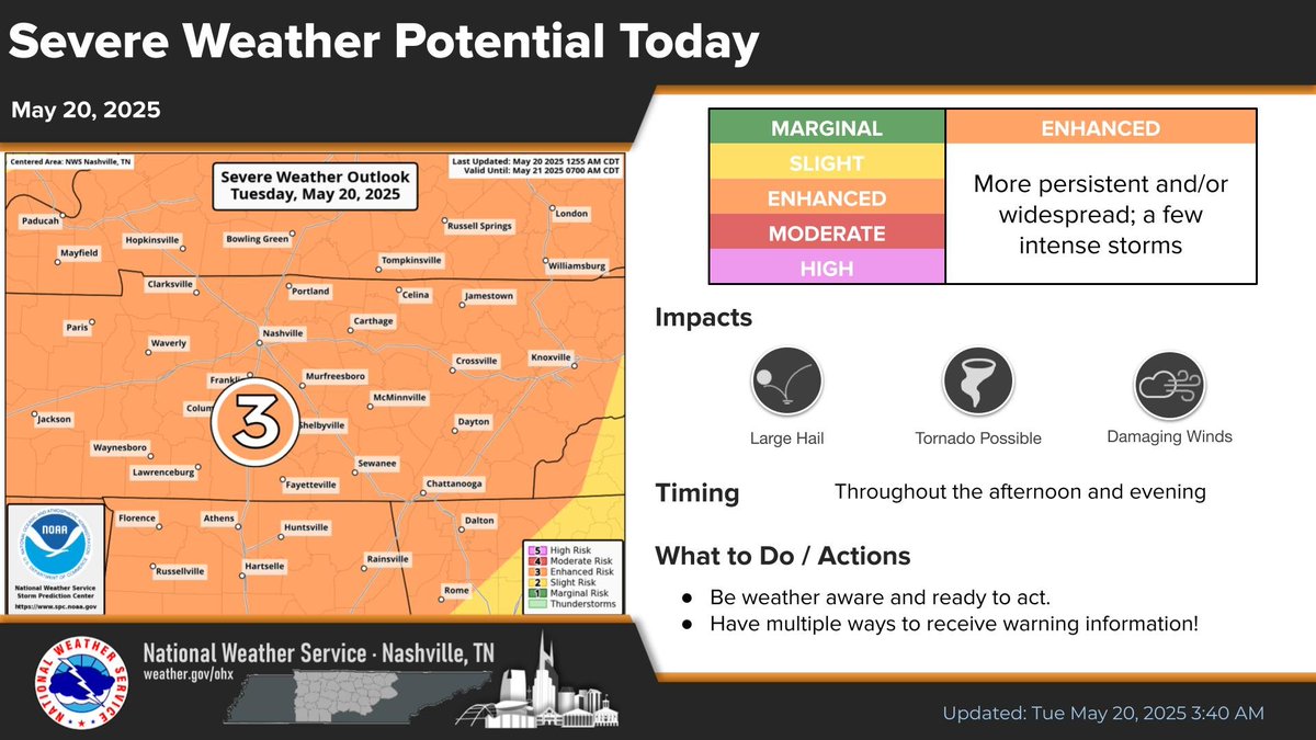
Mid TN remains under an Enhanced Risk (level 3 out of 5) for severe storms today. There will be periods of storms through the day with the main severe risk throughout this afternoon and evening. Damaging winds, large hail, and tornadoes will all be possible.

Mid TN remains under an Enhanced Risk (level 3 out of 5) for severe storms today. There will be periods of storms through the day with the main severe risk throughout this afternoon and evening. Damaging winds, large hail, and tornadoes will all be possible.
TSSAA (@tssaa) 's Twitter Profile Photo

Due to the weather conditions today, the baseball games will be postponed until tomorrow. The entire baseball schedule for the week is being pushed back 1 day. Games will be scheduled to start beginning at 4 pm tomorrow. The Div. II championships will be held on Friday at MTSU.

Marcus Bagwell (@marcus_wx) 's Twitter Profile Photo

THIS IS AN IMPORTANT READ related to our severe storm risk into this afternoon/evening. We are NOT in the clear from this morning's storms. Please stay alert!

ErinTDOT (@erintdot) 's Twitter Profile Photo

🚨MAURY CO/COLUMBIA: A sinkhole has closed lanes of traffic on SR 6 (US 31) NB about 2 miles south of Saturn Pkwy (near intersection of Carters Creek & SR 6). Both NB lanes are closed but one lane of traffic is moving on the shoulder. Updates to come.

🚨MAURY CO/COLUMBIA: A sinkhole has closed lanes of traffic on SR 6 (US 31) NB about 2 miles south of Saturn Pkwy (near intersection of Carters Creek &amp; SR 6). Both NB lanes are closed but one lane of traffic is moving on the shoulder. Updates to come.
NashSevereWx (@nashseverewx) 's Twitter Profile Photo

Widespread rain continues across Middle Tennessee today with embedded thunderstorms possible. •Flash flooding is the primary concern with locally heavy downpours. •Severe threat is low, but a few storms could bring gusty winds. •Best chance for heavier rain is late morning

Spring Hill Weather (@springhillwx) 's Twitter Profile Photo

Just wanted to share these pics of the beautiful Tennessee sunrise my son took at work on Tuesday morning in Franklin. 🧡 📷: Ofc. R. Durham, FPD

Just wanted to share these pics of the beautiful Tennessee sunrise my son took at work on Tuesday morning in Franklin. 🧡

📷: Ofc. R. Durham, FPD
NWS Nashville (@nwsnashville) 's Twitter Profile Photo

There is a low to medium chance (level 2 out of 5) of severe storms Friday afternoon and evening across all of Middle Tennessee. The primary risk is damaging winds and heavy rainfall, with a lesser threat of large hail.

There is a low to medium chance (level 2 out of 5) of severe storms Friday afternoon and evening across all of Middle Tennessee. The primary risk is damaging winds and heavy rainfall, with a lesser threat of large hail.
Spring Hill Weather (@springhillwx) 's Twitter Profile Photo

Some of the damage from the storm last night in Spring Hill from my friend, Sarah McClanahan. This is in The Reserve at Port Royal. Been receiving lots of damage reports this morning from that area. #tspotter NWS Nashville Danielle Breezy Lisa Spencer

Some of the damage from the storm last night in Spring Hill from my friend, Sarah McClanahan. This is in The Reserve at Port Royal. Been receiving lots of damage reports this morning from that area. #tspotter
 <a href="/NWSNashville/">NWS Nashville</a>  <a href="/DanielleBreezy/">Danielle Breezy</a> <a href="/LisaSpencerWSMV/">Lisa Spencer</a>
Davis Nolan (@davisnolan) 's Twitter Profile Photo

The first watch for the day extends to the Tennessee River. EXPECT ANOTHER WATCH LATER to include parts of Middle Tennessee. Threats will be damaging winds, hail, dangerous lightning, and a low-end tornado risk. Rough ETA for Middle TN is Noon-5PM from west to east.

The first watch for the day extends to the Tennessee River.  EXPECT ANOTHER WATCH LATER to include parts of Middle Tennessee.  Threats will be damaging winds, hail, dangerous lightning, and a low-end tornado risk.  Rough ETA for Middle TN is Noon-5PM from west to east.
IEMBot OHX (@iembot_ohx) 's Twitter Profile Photo

[Delayed Report] On Jun 6, at 8:52 PM CDT, 1 ESE Spring Hill [Maury Co, TN] NWS Storm Survey reports Tornado. Delayed report. A tornado moved through portions of Spring Hill, TN the evening of June 6th. The tornado started just west of Ray... #tnwx mesonet.agron.iastate.edu/lsr/?by=wfo&wf…

[Delayed Report] On Jun 6, at 8:52 PM CDT, 1 ESE Spring Hill [Maury Co, TN] NWS Storm Survey reports Tornado. Delayed report. A tornado moved through portions of Spring Hill, TN the evening of June 6th. The tornado started just west of Ray... #tnwx mesonet.agron.iastate.edu/lsr/?by=wfo&wf…