Sloth Weather
@slothwx
Providing local weather for Springfield, MO and its surrounding areas.
ID: 3190952328
https://www.instagram.com/slothweather 10-05-2015 17:16:57
5,5K Tweet
137 Followers
69 Following
 on Twitter photo Slight risk of severe storms tonight and early tomorrow morning. Models showing helicity track along Kansas/Oklahoma border into Missouri. #joplin #carthage #mowx")
 's Twitter Profile Photo")
 on Twitter photo Strong to severe storms are expected by this afternoon and into tonight. There may be multiple rounds of storms through the entire period. Just because one storm moves through does not mean your risk is over! All hazards will be possible, some potentially significant. #mowx #kswx")
 on Twitter photo Storms will develop this afternoon and continue into Tuesday. Multiple rounds of strong to severe storms are expected through the period. Just because one storm moves through does not mean your risk is over! All hazards will be possible, some potentially significant. #mowx #kswx")
 on Twitter photo A tornado watch has been issued for parts of Kansas and Missouri until 9 PM CDT")
 on Twitter photo Severe Thunderstorm Warning including Nixa MO, Ozark MO and Branson MO until 7:15 PM CDT")
 on Twitter photo Severe Thunderstorm Warning including Springfield MO, Republic MO and Battlefield MO until 7:30 PM CDT")
 on Twitter photo Scattered shower and thunderstorm chances this evening into tonight. An isolated strong to severe thunderstorm will be capable of producing damaging wind gusts up to 60 mph and hail up to the size of quarters.")
 on Twitter photo Mamantus clouds looking west from #repmo at the severe storm over #joplin about an hour ago. #mowx")
 on Twitter photo A severe thunderstorm watch has been issued for parts of Kansas, Missouri and Oklahoma until 9 PM CDT")
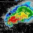
 on Twitter photo Intense storm! #mowx")
 on Twitter photo Severe Thunderstorm Warning including Republic MO, Battlefield MO and Brookline MO until 6:00 PM CDT")
 on Twitter photo Scattered showers and storms will continue this evening across the area, with a Marginal to Slight risk for severe weather. A few of the stronger storms will be capable of producing hail up to half dollars, damaging winds up to 60mph, and frequent lightning. Remain weather aware.")
 on Twitter photo The #Auroraborealis is visible tonight from #repmo! #northernLights #mowx")
@slothwx
Providing local weather for Springfield, MO and its surrounding areas.
ID: 3190952328
https://www.instagram.com/slothweather 10-05-2015 17:16:57
5,5K Tweet
137 Followers
69 Following
 on Twitter photo Another shot about 15 minutes ago from #repmo.")